Agriculture in India is moving away from relying solely on plows, tractors, and weather conditions; digital technologies are beginning to fundamentally change the lives of farmers. Information regarding how much land a farmer owns, what crops they are growing, and the damage sustained by a crop on a specific field is now being collected using digital methods. This can facilitate more effective distribution of government programs, prevent errors during crop surveys, and enable timely consultation for farmers.
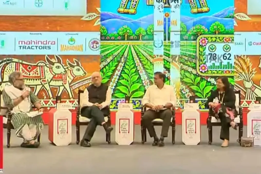
Experts presented exactly how digital technologies are transforming agricultural practices at the session 'Digital Farming: India Shows the Way,' organized by India Today Group at Bharat Mandapam in Delhi. The discussion included Dr. Devesh Chaturvedi, former Central Secretary for Agriculture, Nishant Varwade, Agricultural Secretary of the Madhya Pradesh government, Roli Jindal, co-founder and CEO of RSMI CropLitics, and agrarian influencer Paragat Singh.
Dr. Devesh Chaturvedi noted that the National Mission for Digital Agriculture is a step that will lead to significant changes in the agricultural sector. Under this mission, AgriStack is being developed, which includes three key systems: Farm Registry, Farmer ID, and Digital Crop Survey.
The Farm Registry system assigns a unique identifier to every field in the country, which can be considered a field number based on Aadhaar. Along with this identifier, the geographical location of the field—its latitude and longitude—is registered. This simplifies the determination of the field's location and the calculation of its area.
In the Farmer ID system, each farmer is issued a unique 11-digit identifier. Its database stores information such as the farmer's Aadhaar number, mobile phone number, land records, and the farmer's share in the field. According to Dr. Chaturvedi, since multiple family members often have rights to the same land with different shares, it is difficult to determine how much land actually belongs to each farmer. The digital farmer ID will make this information transparent, allowing farmers to view their own data independently, and relevant departments to use it only with the farmer's consent.
The third component is the Digital Crop Survey. Within this system, crop information is entered via a mobile application after visiting the field. The surveyor photographs the field and indicates which crop is planted there. Furthermore, satellite imagery can be used to identify crops, which reduces the likelihood of false data entry during crop assessment. Dr. Chaturvedi reported that approximately 110 million farmer IDs have been created so far, and the digital crop survey is being conducted for about 300 million parcels. Geo-tagging of about 80 percent of the parcels has also been completed.
Madhya Pradesh Agricultural Secretary Nishant Varwade stated that the digital agriculture mission has been implemented in the state in the form of a campaign. Out of approximately 110 million farmer IDs created across the country, about 11.3 million belong to Madhya Pradesh. He stated that work on farmer IDs and geo-tagging in the state is 100% complete. He clarified that this work was not limited only to the Department of Agriculture but also involved the Revenue Department and other agencies. As part of this campaign, the digitization of land records (Khasra-Khatauni), as well as pending cases related to land re-registration and division, were also included in the process.
According to Varwade, through AgriStack, benefits, including fertilizers and subsidies, are provided in Madhya Pradesh. Work is also underway to integrate data on dams and canals belonging to the irrigation department using digital mapping. This system can help reduce disputes that arise when several brothers or family members farm on the same land, concerning the receipt of fertilizer subsidies, sale of crops at the Minimum Support Price (MSP), or compensation for crop damage.
Roli Jindal, CEO of RSMI CropLitics, emphasized that using digital technologies in agriculture offers three main advantages: speed of information retrieval, the ability to monitor large areas simultaneously, and increased data accuracy. She explained that thanks to satellite data and machine learning, it is now possible not only to determine which crop is planted in a field but also to understand the overall condition of that crop. For example, during wheat cultivation in Uttar Pradesh, the increase in temperature at the end of March and early April affects the grain formation process.
However, this impact is not uniform across all fields. The company has developed models that allow satellite data to determine exactly which fields have been affected by disruptions in the wheat grain formation process. Roli Jindal added that improving these models requires data from different states, districts, and various crops. The more diverse and extensive the data the machine studies, the higher its capacity for recognition and prediction will be.