NOAA predicts El Niño could be the strongest recorded since 1950
Read more
Olhar Digital
olhardigital.com.br

NOAA predicts El Niño could be the strongest recorded since 1950

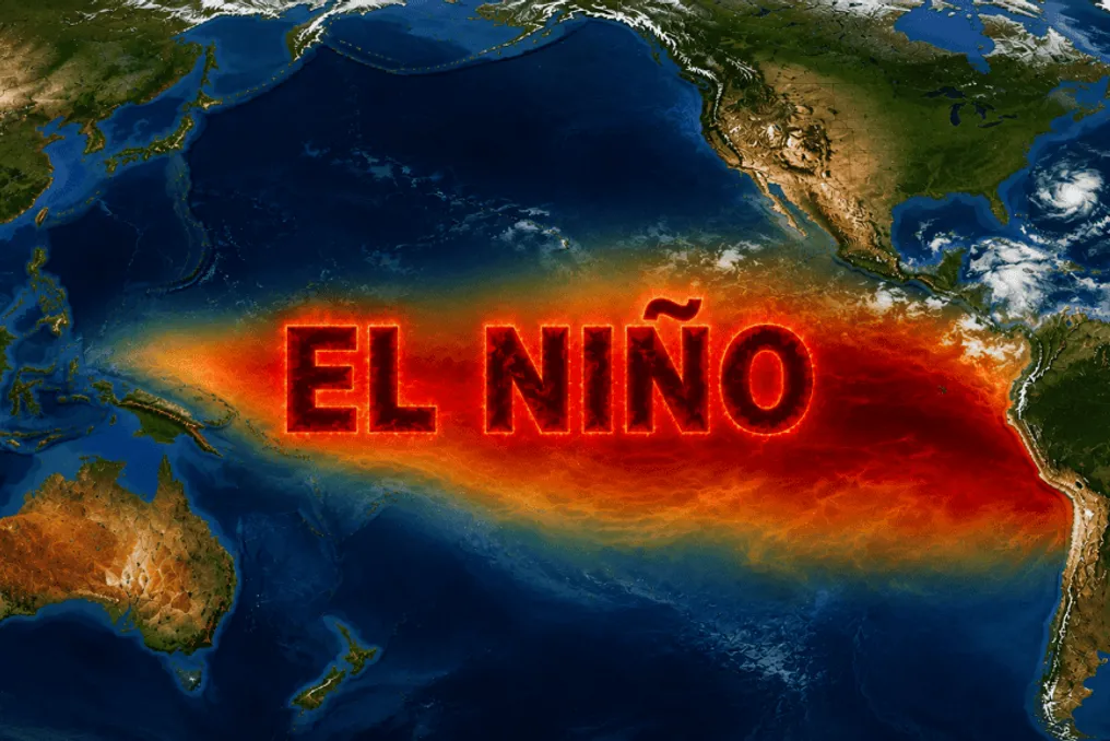
The El Niño phenomenon is intensifying in the Pacific Ocean and has the potential to reach a very strong intensity by March 2027. NOAA calculates there is a 60% probability that this episode will be the most intense since 1950.

According to the American agency, the climate event is expected to continue strengthening until the end of the year. There is a greater than 79% probability that it will remain in the strong or very strong classifications between January and March 2027.

Data released on Thursday (12) indicates that the water temperature in the Equatorial Pacific continues to rise. Specifically in the Niño 3.4 region, a key indicator for monitoring the phenomenon, warming reached 2.5°C above average in October, compared to 2.1°C in September.

However, the progression of El Niño does not depend solely on ocean temperature; the atmosphere must also react to the warming, showing changes in winds, pressure, and rainfall distribution over the Pacific.

In a new report, NOAA confirmed that these atmospheric indicators persist, suggesting that the ocean and atmosphere are working together to keep the phenomenon active.

Michelle L’Heureux, who is responsible for the El Niño monitoring team at the agency, informed g1 that the current El Niño only trails the record set during the same period in 1997. She emphasized that the phenomenon already exhibits one of the highest levels of Pacific warming in recent decades and may still increase its intensity in the coming months.

The 60% projection for a record takes into account the quarters from October to December and November to January.

It is important to note that the expression 'super El Niño' is not an official NOAA classification. The agency uses four categories to measure the event's intensity: weak, moderate, strong, and very strong. An episode is classified as very strong when the agency's index reaches at least 2°C above average over a three-month period, which is the category often informally mentioned as super El Niño.

The phenomenon is part of ENSO (El Niño-Southern Oscillation), a climate cycle that alternates between warm, cold, and neutral phases. El Niño is characterized by a warming of at least 0.5°C of the Equatorial Pacific waters.

Pacific warming alters atmospheric circulation and impacts rainfall and temperature patterns in various regions of the globe. In Brazil, for example, the effects on precipitation vary depending on the geographical area.

Another consequence linked to the phenomenon is an increase in the frequency of heatwaves. Experts warn that long periods of high temperatures are one of the expected impacts, particularly during spring and summer. Furthermore, El Niño contributes to raising the global average temperature, adding to global warming in intense episodes, given that oceans already record temperatures above historical averages.

Similar stories

Studies indicate that El Niño and warming could make 2026 the hottest year in history
Read more
olhardigital.com.br

Studies indicate that El Niño and warming could make 2026 the hottest year in history

There is a 95% probability that the year 2026 will surpass the global temperature record set in 2024, according to estimates from the American research group Berkeley Earth. This projection takes into account the impacts of the El Niño phenomenon along with global climate changes.

This forecast coincides with the start of COP31, a climate conference organized by the United Nations (UN), which began on Monday (9) in Antalya, Turkey. The event serves as a meeting point for negotiators and leaders from various nations.

The Berkeley Earth assessment was recently completed and is supported by forecasts from the World Meteorological Organization (WMO), which anticipates that the year will be one of the four hottest ever recorded. Furthermore, the WMO projects that an exceptionally intense El Niño episode will persist in 2027, contributing to rising temperatures.

El Niño is a natural climatic event characterized by the release of heat from the oceans into the atmosphere. According to WMO Secretary-General Celeste Saulo, the water masses are warmer than ever, implying greater availability of heat to be released.

This additional heat adds to global warming, which is mainly caused by the increase in atmospheric carbon dioxide concentration, resulting largely from the burning of fossil fuels. Thus, the influence of El Niño occurs within a scenario of thermal elevation already driven by human actions.

One of the main focuses of the conference held in Turkey includes the need to reduce greenhouse gas emissions and assist countries in adapting to extreme weather events. Among the examples of challenges debated are large fires that occurred in Europe and the collapse of glaciers in Nepal, which resulted in over a thousand deaths.

Discussions also cover various proposals aimed at reducing dependence on fossil fuels. Turkey expressed interest in debating a new goal to increase the use of electricity as a substitute for these sources. Meanwhile, the European Union advocates that electrification must be complemented by the expansion of clean energy sources. Saudi Arabia and Russia, for their part, have supported the temporary maintenance of gas use.

Another crucial aspect addressed is the funding allocated for climate adaptation in developing nations. In previous meetings, wealthier countries committed to increasing resources allocated for this purpose, with the goal of reaching at least US$85 billion by 2035, which is equivalent to approximately R$463.25 billion. Data from 2024 indicated that about one-third of this amount had already been reached.

Super El Niño breaks 40-year warming record and triggers alerts in Brazil
Read more
olhardigital.com.br

Super El Niño breaks 40-year warming record and triggers alerts in Brazil

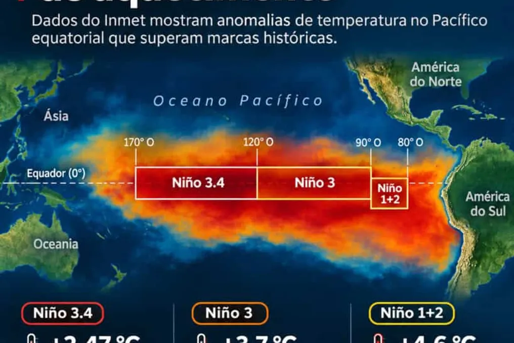
According to information released by Olhar Digital, data provided by the National Institute of Meteorology (Inmet) indicates that the El Niño phenomenon reached a historic warming level in October. The anomaly registered in the Niño 3.4 region reached 2.47 °C above average, surpassing the 2.07 °C level observed in October 1982.

Weekly measurements also set new records. In the Niño 3 region, the temperature registered 3.7 °C above average in the last week of the month, exceeding the 1981 mark. In the Niño 1+2 area, near Peru and Ecuador, the difference was over 4.6 °C, matching the peak of June 1983.

When the phenomenon was confirmed in June this year, the World Meteorological Organization (WMO) was already signaling a high probability of intense severity. At that time, climatologist Carlos Nobre, who holds a Ph.D. in Meteorology from the Massachusetts Institute of Technology (MIT) in the USA and is internationally recognized for global warming, warned about the seriousness of the scenario of a possible 'Super El Niño.'

The specialist stated that 'The chances of this being one of the most intense events ever recorded are extremely high. Therefore, we need to be very prepared.' He emphasized that the global outlook has undergone drastic changes, given that continuous ocean warming and energy accumulation in the atmosphere cause extreme events, previously uncommon, to occur much more frequently in recent decades.

Inmet's temperature records confirm that temperatures in various parts of the country exceeded the limits of the last four decades, realizing the scenario predicted by specialists. According to Nobre, the phenomenon also reached unprecedented levels in oceanic measurements conducted since the 1950s.

This unprecedented thermal alteration profoundly modifies atmospheric dynamics. With warmer seas, evaporation increases, which drives severe and simultaneous events, exactly as the specialist had anticipated.

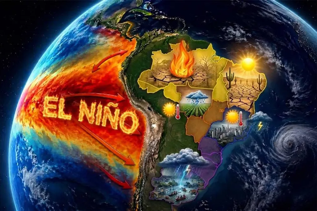
The North and Northeast regions feel the effect directly on humidity. The scientist explained that 'Typically, El Niño leads to a period of severe drought, heatwaves in the Amazon, and much of the Northeast, which is what is happening.' He added a warning, mentioning that due to the drought and heatwaves, vegetation becomes highly flammable, and organized crime is causing fires, most of which are illegal and intended for deforestation.

In contrast, the South of the country faces a situation of excess water. 'Instead of drought, there is excessive rainfall. Throughout Southern Brazil, even some part of Southern Mato Grosso do Sul, there is excess rain, as predicted.'

The warming also intensifies severe and atypical occurrences in the atmosphere of the Southern region. The researcher pointed out that 'There are also climatic phenomena, extratropical cyclones, low-pressure systems; they are stronger. And not just excessive rain, but strong winds are breaking records, as are tornadoes.'

Nobre stressed that the modification in the climate pattern imposes serious challenges on cities without adequate infrastructure. In the Southern states, there was a record number of tornadoes, something very rare in those locations. Thus, the entire system has never been prepared for tornadoes like those in the center-southeastern region of the United States, which historically present them.

To prevent future tragedies, the specialist advocates that the country adopt the urban protection models used in regions accustomed to such events in the United States. He cited the example of houses with underground areas, where people can shelter during a tornado, preserving themselves even if the structure is damaged by strong wind.

Physical mechanisms explain how ocean heat provides so much energy. With warmed oceans, evaporation is significantly higher, and the atmosphere reacts with faster winds in the southern hemisphere. This accelerated airflow enhances precipitation volumes. 'Rain in the Pacific, up to the coast of South America, increases significantly, and the phenomenon gains strength. This induces severe droughts in several places, especially in South America, the Amazon, and the Northeast.'

Additionally, a meteorological phenomenon occurs where the speed of the subtropical jet stream, the atmospheric wind current of the southern hemisphere, grows considerably when crossing South America. This increase in speed causes the air to rise with greater intensity, being a main factor for intense rains.

The specialist adds that the effects persist even after the official end of the phenomenon in the Pacific, as they are maintained by the warming of the Atlantic Ocean. This dynamic extends both periods of drought and extreme floods.

Given this complex scenario, prevention becomes crucial to protect millions of Brazilians. Data from the National Center for Monitoring and Alerts of Natural Disasters (Cemaden) show that tens of millions of people live in areas susceptible to floods and landslides.

The survey details the exact proportion of the population exposed to risk in the national territory. The climatologist recalled a 2018 study that analyzed almost a thousand municipalities, measuring how many people were subject to excessive rain, flooding, flash floods, inundations, and landslides. Out of more than 100 million Brazilians assessed in that study, 10 million were in risk zones and 2 million in areas of very high risk, the latter of which should not remain there.

With historical records from October confirming the accelerated pace of climate change, the country must prioritize adaptation. The alert issued by the researcher summarizes the magnitude of the challenge presented: 'So, we have to be prepared because, with global warming, all hydrometeorological phenomena will be breaking records worldwide—and certainly in our country.'
El Niño Phenomenon records historic warming in the Pacific Ocean in October 2026
Read more
olhardigital.com.br

El Niño Phenomenon records historic warming in the Pacific Ocean in October 2026

The 2026 El Niño event reached a record warming level during the month of October. According to data provided by the National Institute of Meteorology (Inmet), the surface temperature of the Pacific Ocean exceeded the average by 2.47 °C in the area designated as Niño 3.4.

The Niño regions are areas located in the Equatorial Pacific Ocean, used by meteorological specialists to monitor water temperature. While Niño 3.4 is situated in the central part of the ocean, Niño 3 is positioned further east, towards South America. In this latter region, the temperature variation reached 3.56 °C in October.

The survey conducted by Inmet also pointed to maximum records in weekly measurements. Specifically in the Niño 3 region, the temperature registered 3.7 °C above average in the last week of October. This value constituted the highest record in the historical series started in 1981, surpassing the previous mark of 3.6 °C, which had been recorded in December 1982.

Near the coasts of Peru and Ecuador is the Niño 1+2 region. In this location, the temperature difference reached 4.6 °C in the same period, equaling the record established in June 1983. However, this area has little influence on the Brazilian climate.

Meteorologist Leydson Dantas emphasized that monthly and weekly data cannot be directly compared, as they cover different time periods. He stated: 'It is important to note that comparing monthly and weekly data requires caution, as they represent distinct reference periods.'

The phenomenon began to develop in June 2026 and showed a rapid increase in temperature in subsequent months. The World Meteorological Organization (WMO) indicated the possibility that this episode could be one of the most intense ever documented.

El Niño is characterized by the warming of the surface waters of the Equatorial Pacific Ocean above normal levels. This thermal increase causes changes in atmospheric circulation and modifies rainfall and temperature patterns in various parts of Brazil. Inmet clarifies that the impacts of this phenomenon are determined by the intensity of the warming, the season, and the specific atmospheric conditions of each locality.

Popular