The History of Heidelberg in Gauteng: A Little-Known Historical Center
Read more
Getaway
getaway.co.za

The History of Heidelberg in Gauteng: A Little-Known Historical Center

Located approximately 50 kilometers southeast of Johannesburg, the city of Heidelberg possesses a rich history that often goes unnoticed. It has witnessed events that shaped former Transvaal, including its brief period as a republican capital and its involvement in the South African War.

Proclaimed in 1866, Heidelberg developed into a significant regional center. Its preserved landmarks and historical sites allow for a more detailed study of the past and the people who lived in this region.

The early development of Heidelberg is closely linked to the German merchant Heinrich Julius Friedrich Christian Weckermann, who established a trading store on Langlaagte farm. A settlement formed around this location before the official proclamation of the city in 1866.

Republican Period and Architectural Monuments

During the First Anglo-Boer War (1880–1881), Heidelberg briefly served as the government center of the Zuid-Afrikaansche Republiek (ZAR). As no British troops were stationed in the city, it provided the Boer government with a base for the restoration of the republic. The start of the war was marked by the raising of the republican flag in Heidelberg on December 16, 1880.

Klipkerk remains one of Heidelberg's most recognizable attractions. Its history dates back to an earlier church, Kruiskerk, which was built on the same site in 1865. The foundation stone of the current building was laid by Commandant General P. J. Jobert on April 12, 1890. The church, designed by architects Brislin and Sil in the Norman style, was consecrated in March 1891. Although its tower collapsed in 1909 due to structural problems and heavy rain, it was subsequently restored to its original form.

Less Obvious Pages of History

Some of Heidelberg's most important historical events are less visible. During the South African War (1899–1902), British troops established concentration camps for displaced Black and white South Africans. The experience of Black people in these camps received significantly less historical attention.

Research by historians Willem Pretorius and Fransjoohan Pretorius documents four Black camps in the wider Heidelberg area: Heidelberg, Nigel, Balfour, and Greylingdast. Approximately 2300 Black people were held at the Heidelberg camp. Conditions were harsh due to shortages of food and medical care, and residents were also required to provide labor for the British army. Academic studies record an improvement in medical services after June 1901, but the camp had already suffered significant population losses.

Historical records indicate the death of 150 people, including 121 children. On August 28, 2026, the Heidelberg Heritage Association installed Blue Heritage Plaque No. 85 on the grounds of the former camp cemetery, located behind the Heidelberg Mall shopping center. The burial site was rediscovered in June 1999 while studying an old map, and about 30 graves were identified. This plaque draws more attention to the painful chapter of Heidelberg's history and the families affected by the war.

The Heidelberg railway station opened in October 1896 and was declared a national monument in 1975. In 1995, it was converted into the Heidelberg Heritage Museum, which houses historical photographs, artifacts, and railway souvenirs. The station also reflects the history of racial segregation in the country, as separate facilities were previously provided for Black and Indian passengers.

More recent history of the city is concerning. A September 2026 report described the deterioration of the building, which had been closed to the public for over a year due to disputes over management and maintenance. It remains an important heritage site, but visitors should check accessibility before visiting.

Literary Heritage

Heidelberg was also home to Dr. Andries Gerhardus Visser, one of the most renowned poets of Afrikaans literature. Born in 1878, Visser initially trained as a teacher before studying medicine in Edinburgh. He settled in Heidelberg in 1916, where he opened his medical practice and continued writing poetry. His former residence and consulting rooms, built in 1890, still stand at the corner of Van der Weskhoizen and HF Verwoerd streets. The property is marked with a heritage plaque that once functioned as a museum, displaying his personal belongings and cultural artifacts.

The history of Heidelberg extends far beyond its most famous attractions. Its brief period as a republican capital, the stories of people held in the concentration camp, as well as its railway and literary connections, reveal various facets of South Africa's past. For travelers interested in heritage, the city offers a worthwhile detour from Gauteng's more famous sights. Its history is not always pleasant, but understanding it makes the visit much more meaningful.

Traveler's Note:

It is reported that the Heidelberg Heritage Museum was closed to the public in September 2026. It is recommended to check the availability of heritage sites before visiting.

Similar stories

The Nakasendo Historical Road: A Hiking Trail Between Japan's Mountain Villages
Read more
getaway.co.za

The Nakasendo Historical Road: A Hiking Trail Between Japan's Mountain Villages

Although Japan's railway network facilitates travel between major cities, the Nakasendo road offers an opportunity to explore the country at a slower pace. This historic mountain route once connected Kyoto and Edo (now Tokyo). Today, preserved sections allow hikers to pass through traditional post towns and the Kiso Valley, where parts of the original route remain accessible.

Nakasendo, which translates to 'mountain road,' was created during the Edo period of Japan (1603–1868) and stretched approximately 530 km, forming part of five major national thoroughfares. Although much of the original road has disappeared, the best-preserved sections give travelers a chance to explore Japan's rural history on foot.

This path was used by samurai, merchants, pilgrims, and government officials traveling between Kyoto and Edo. There were 69 post towns along the route, known as shukuba, which provided lodging, food, and supplies. These towns held particular significance within the Sankin-kōtai system, which required feudal lords to travel to Edo annually with their retinues.

Unlike the coastal Tōkaidō route, Nakasendo traversed the mountainous interior of Honshu. Several historical sections remain in the Kiso Valley, including the former post towns of Magome, Tsumago, and Narai. The 8 km route between Magome-juku and Tsumago-juku is considered one of the most popular sections of Nakasendo. The hike takes about three hours at a leisurely pace and is suitable for most reasonably fit hikers.

The route passes through forests, agricultural fields, and small settlements, while Otaki and Metaki waterfalls offer stopping points. Traditional tea houses also provide pleasant breaks. The trail is marked in English and Japanese, although some sections briefly follow modern roads. When traveling with luggage, visitors can arrange delivery between villages through their tourist information centers; this service is seasonal, so advance checking is advised.

For a more challenging trek, there is an 8.5 km section between Yabuhara and Narai that crosses the Torii Pass. It takes about two and a half hours and includes a steep ascent from Yabuhara. The former post towns are the main reason for exploring the Kiso Valley, as each one showcases a different perspective on communities that developed along this main artery.

Located in Gifu Prefecture, Magome is a popular starting point for the hike to Tsumago. Its historic main street is adorned with traditional buildings, shops, restaurants, and museums. This town is also the birthplace of Japanese novelist Shimazaki Tōson, and a museum dedicated to his life and work highlights his connection to the region.

In Nagano Prefecture, Tsumago is one of Japan's best-preserved post towns. Its preservation is largely due to local residents who began protecting the historic settlement in 1968, resisting modern development that affected many rural communities. Measures included restricting vehicle traffic on the main street during the day and concealing overhead power lines. Visitors can tour traditional inns, shops, and museums, including restored Hondzin and Wakihondzin, which once accommodated travelers depending on their status. Staying overnight is recommended for those wishing to spend more time exploring the village.

Further along Nakasendo, Narai was once one of the wealthiest post towns on the route. Known as 'Narai of a Thousand Houses,' its historic main street stretches for about one kilometer. The village is also famous for Kiso lacquerware—a traditional craft found in local workshops and shops. Narai is accessible by train and marks the end of the hike across the Torii Pass from Yabuhara.

Kiso-Fukushima offers another perspective on the history of this thoroughfare. One of the four major checkpoints, where officials monitored travelers and regulated movement during the Edo period, was located here. The restored Fukushima checkpoint now functions as a museum, providing insight into the control measures applied to travel at that time.

Suitable months for hiking the Nakasendo generally include April and May, as well as July through November. Spring and autumn are considered particularly popular, although autumn accommodation can book up quickly. June and early July are often accompanied by rain, and winter conditions can make the trails slippery.

Accommodation options include traditional Japanese inns known as ryokan and small family guesthouses called minshuku. Tsumago and Narai are good options for those who wish to stay in historic post towns, while Kiso-Fukushima offers more lodging choices. The Kiso Valley is accessible by public transport. From Tokyo or Kyoto, one can reach Nagoya and transfer to the JR Chuo line.

To travel to Magome, take the Nakatsugawa station and board a local bus. In Tsumago, you can arrive via Nagiso station, followed by a bus or taxi. Narai has its own railway station within walking distance of the historic town. Allow about three hours for the walk from Magome to Tsumago, not including time spent touring the villages. Bus services are limited, so check local schedules before traveling.

It is recommended to wear comfortable walking shoes, carry drinking water, and dress appropriately for the weather. Shops are scarce along forest sections, and parts of the trail pass through bear habitats. Follow local safety advice and use a bear bell if recommended.

Nakasendo allows travelers to step outside the major cities of Japan and experience the history of the communities situated along its old mountain road. From the popular Magome-Tsumago route to the preserved streets of Narai, the Kiso Valley is more than just a brief stop on a Japanese itinerary. For those interested in combining trekking and history, this is a route worth dedicating time to.

Ancient City of Cahokia in the American Midwest: An Exploration of Ruins and Historical Monuments
Read more
getaway.co.za

Ancient City of Cahokia in the American Midwest: An Exploration of Ruins and Historical Monuments

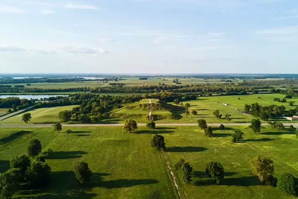
Imagine a view from the top of a massive earthen mound, overlooking a landscape that was once home to one of North America's largest cities. About a thousand years ago, this area, located near the Mississippi River, was inhabited by homes, ceremonial grounds, bustling public plazas, and thousands of people leading their daily lives.

Today, much of this city is hidden beneath the surrounding landscape. However, its massive grassy mounds, ancient gathering places, and archaeological remains are still available for study at the Cahokia Mounds State Historic Site in Illinois.

Located near Collinsville, outside of St. Louis, Missouri, Cahokia was once a thriving indigenous urban center. During its peak, roughly between 1050 and 1150 AD, it is estimated that between 10,000 and 20,000 people lived there. Its outstanding earthworks and carefully organized settlement structure made it one of the most significant pre-Columbian cities in North America.

In 1982, Cahokia was designated a UNESCO World Heritage site, and it is now a fascinating destination for travelers interested in the history, archaeology, and ancient landscapes of the American Midwest. Although much of the former cityscape is no longer visible, there is much to discover on foot.

Key Attractions of Cahokia

No visit to Cahokia is complete without seeing Monks Mound—the largest prehistoric earthwork structure in America. This enormous flat mound covers about six acres and rises approximately 30 meters above the surrounding terrain. It was built by generations of Cahokian residents who transported and stacked countless baskets of earth to create its impressive terraces.

Today, visitors can climb the stairs to the top, where the elevated position offers a different perspective on the archaeological site and the surrounding landscape. From here, it is easier to appreciate the scale of Cahokia and imagine what its central district looked like at the height of the city's life. The contrast between the ancient earthworks and the modern St. Louis urban area creates a particularly striking view.

It is recommended to allocate time to explore the base of the mound and the adjacent paths, rather than treating the ascent as a quick photo stop. Another important spot is the Grand Plaza—a vast open space that once served as the center of Cahokia's public life. This plaza was intentionally leveled and surrounded by significant structures, including several earth mounds. It provided a venue for gatherings, ceremonies, and other community events.

Today, the open landscape allows for the study of the ancient city's layout at a slower pace. Walking through this area, visitors can see how the mounds and public spaces were situated relative to each other. It is also one of the best places to grasp the colossal scale of the settlement; what initially appears as a cluster of grassy hills gradually reveals itself as a meticulously organized urban landscape.

Woodhenges and the City Perimeter

One of the most intriguing features of this site is Woodhenge—a reconstructed circle of large wooden posts associated with solar observation. Archaeologists believe the original structures were used to mark important solar events, including solstices and equinoxes. These observations helped Cahokian residents track seasonal changes and organize aspects of their agricultural and ceremonial calendars. The reconstructed wooden circle gives visitors a tangible sense of what this structure might have looked like a century ago.

If your visit coincides with a seasonal solar event, it is worth checking if any special interpretations or events are scheduled. Otherwise, Woodhenge remains a worthwhile stop for anyone interested in ancient astronomy and the relationship between early societies and nature.

Beyond the main monuments, Cahokia is a place worth exploring on foot. The area includes several walking trails that guide visitors through different parts of the archaeological landscape. Along the way, you may encounter additional mounds, open meadows, and traces of a huge wooden palisade that once encircled the city's central district. The original palisade stretched approximately two miles and was repeatedly rebuilt throughout Cahokia's history. Although much of the structure no longer survives, its archaeological trace helps researchers understand how the city was organized and defended.

For those who enjoy combining history with outdoor recreation, the trails offer a more relaxed way to experience the site. They also provide an opportunity to appreciate the surrounding natural landscape, especially the prairie vegetation. Comfortable walking shoes, sunscreen, a hat, and drinking water are recommended, especially during warmer months.

For a better understanding of what is seen outdoors, take time at the Cahokia Mounds Interpretive Center. The center provides information about the people who built the city, their daily lives, agricultural practices, and the archaeological discoveries that helped reconstruct Cahokia's history. However, visitors should know that the cultural exhibition galleries are currently closed while the site reviews its collections and continues consultations with descendant Native communities.

The vestibule, which includes a model of the site, a canoe exhibit, a temporary display, a gift shop, and visitor amenities, is open from Wednesday to Sunday from 9:00 AM to 3:00 PM according to current visitor information. It is advisable to check the official website before visiting, as access to exhibits and amenities may change.

If you prefer to explore with someone knowledgeable about the site's history, consider joining a guided tour. Cahokia currently offers free guided tours covering Monks Mound and the Grand Plaza. The published schedule lists a Monks Mound tour at 10:00 AM and a Grand Plaza tour at 1:00 PM, from Tuesday to Sunday. Tours last about an hour. Advance registration is required, so contact the site before visiting to confirm availability and arrangements.

A guided tour can add valuable context to the landscape, especially when it comes to understanding the purpose of individual mounds and the significance of various city spaces.

The Cahokia Mounds State Historic Site is located at 30 Ramey Street in Collinsville, Illinois, approximately 13 km from downtown St. Louis, Missouri. Its proximity to St. Louis makes it an accessible day trip for travelers exploring the city and the wider region. For the latest information on operating hours, tour bookings, and visitor updates, please refer to the official Cahokia Mounds website.

Cahokia may no longer be the bustling city it once was, but its preserved monuments offer an exceptional opportunity to explore a little-known chapter of American history. From climbing Monks Mound to walking through the Grand Plaza and standing among the reconstructed Woodhenge posts—a visit allows one to view the scale and ingenuity of this ancient civilization from a new perspective. For travelers passing through the American Midwest, it is a fascinating detour, offering something entirely different from the region's more conventional city attractions.

Ciudad Perdida: Ancient Archaeological Site in the Colombian Jungle
Read more
getaway.co.za

Ciudad Perdida: Ancient Archaeological Site in the Colombian Jungle

Deep within the Sierra Nevada de Santa Marta tropical forest in Colombia stand ancient stone terraces amidst tall trees, rushing rivers, and misty mountains. This outstanding archaeological site, known as Ciudad Perdida or the Lost City, offers insight into the achievements of the Tayrona civilization and the indigenous heritage that continues to shape the region.

This multi-day trek passes through the tropical forest, crosses rivers, and follows steep mountain trails before reaching a network of stone platforms built centuries ago. However, Ciudad Perdida is more than just a remote archaeological find. Local communities call it Tayrona, and it is located on ancestral lands where cultural traditions, spiritual beliefs, and environmental stewardship are closely intertwined with the land.

Ciudad Perdida is situated on the northern slopes of the Sierra Nevada de Santa Marta, a mountain range that rises sharply from the Caribbean coast of Colombia. Archaeologists generally date the earliest settlement of the site to the seventh or eighth century, although its development continued for several centuries.

Architecture and Settlement Structure

Built by the ancestors of the region's indigenous people, Tayrona became an important center in a wider network of settlements connected by mountain trails. Its elevated position above the Buritaca River basin placed it in a landscape of exceptional ecological diversity, where tropical forests meet changing mountain climates.

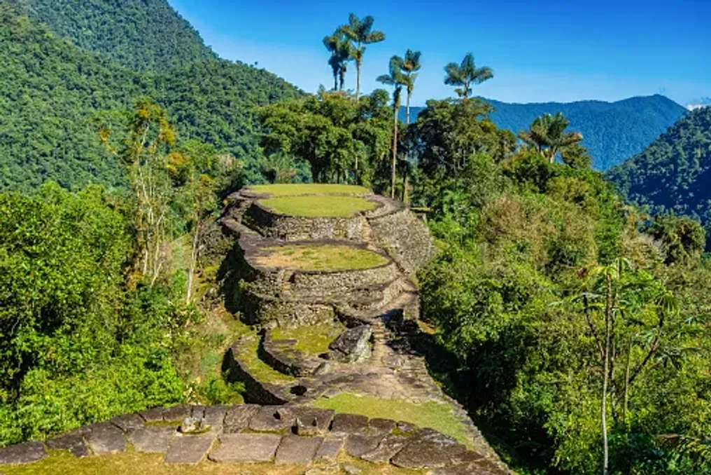
The settlement was not a city with monumental stone palaces. Instead, its architecture reflects a deep understanding of the terrain, including carefully designed terraces, stone staircases, retaining walls, and circular platforms adapted to the steep hillsides.

Over 200 archaeological structures have been identified at the site. The stone terraces supported round houses built from perishable materials such as wood and thatch, while paved paths connected different parts of the settlement.

The builders also developed systems for rainwater management and slope stabilization. Retaining walls supported the terraces, and stone pathways helped link residential areas, public spaces, and other structures on uneven terrain.

Rather than leveling the landscape, the builders worked in accordance with its natural contours. The result was a complex arrangement of platforms and paths that merge with the surrounding forest, demonstrating the engineering skills and ecological knowledge of the people who lived there.

Discovery and Scientific Study

Although local communities knew about the region and its history, Ciudad Perdida attracted widespread archaeological attention only in 1975 when remnants were discovered by individuals searching for pre-Columbian artifacts. This discovery followed a period of looting that damaged archaeological sites throughout the Sierra Nevada.

Subsequent archaeological expeditions documented the settlement, and the Institute of Anthropology and History of Colombia, known as ICANH, began a program of research, conservation, and restoration in 1976. This work helped establish Tayrona as one of Colombia's most important archaeological sites. Its terraces and paths provide valuable evidence of how communities organized settlements, managed steep topography, and maintained connections in the mountainous region.

Today, conservation remains a central element of site management. The stone structures are subject to heavy rainfall, vegetation growth, and human activity. Their protection requires careful visitor management and respect for the broader landscape.

Walking among the terraces offers a different experience compared to visiting archaeological sites dominated by monumental buildings. At Tayrona, the ruins are integrated into the forest, and the structures are interspersed with vegetation, uneven ground, and changes in elevation.

Circular foundations indicate where houses once stood, and larger platforms suggest areas used for public events and daily life. Stairs connect different levels, and paved paths show how people moved through the settlement.

Most information about the city's history comes from archaeological data rather than surviving written records. Therefore, the terraces are more than picturesque ruins; they offer clues about a society whose achievements were closely tied to the surrounding landscape.

Cultural Significance and Management

Ciudad Perdida is located on the ancestral territory of four indigenous peoples: the Kogi, also known as Kaggaba; the Arhuaco, or Iku; the Wiwa, and the Kankuamo. These communities maintain cultural, spiritual, and historical ties to the Sierra Nevada de Santa Marta. Their connection to the mountains extends beyond individual archaeological sites to encompass rivers, forests, peaks, and broader territories that sustain their traditions and way of life.

For these communities, the Sierra Nevada is not merely a scenic mountain range. It is part of a living cultural landscape where the health of the natural environment and the well-being of its inhabitants are closely interwoven. Consequently, Tayrona cannot be viewed simply as an abandoned city. Its importance continues through the living heritage of the indigenous peoples, who recognize the landscape as part of their ancestral world.

The Sierra Nevada is a place where environmental conservation and indigenous beliefs are closely linked. Traditional authorities continue to emphasize the importance of caring for the land and respecting sacred sites.

In October 2026, this interconnectedness was reflected in the temporary closure of the archaeological park. At the request of traditional indigenous authorities, ICANH announced that the site would be closed from October 1st to 15th to allow the land a period of rest and time for internal spiritual practices. The park subsequently reopened to visitors on October 16, 2026, with regular operating hours of 7:00 AM to 3:00 PM. This decision illustrates why access to Tayrona cannot be understood solely from a tourism schedule: the cultural and spiritual practices of the indigenous peoples are a vital consideration in site management.

Travelers can approach this experience with greater understanding by listening to authorized guides, adhering to local protocols, and recognizing that visiting an archaeological site does not mean the entire surrounding area is open for unrestricted exploration.

Journey to the Lost City

Reaching the Lost City requires significantly more effort than visiting a typical attraction. The journey usually begins in Santa Marta, a coastal town that serves as the main base for organizing treks into the Sierra Nevada. From Santa Marta, travelers travel by road to the rural settlement of Machete Pelao, also known as El Mamei, from where the route begins. The trail passes through forested hills, river valleys, and rural communities before reaching the archaeological park.

Most routes take four days round trip, although options ranging from three to six days may be available depending on the operator and itinerary. The hike involves humid conditions, steep ascents, muddy trails, and river crossings. Heavy rains can make certain sections particularly challenging.

Accommodation is typically provided in basic camps along the route, where tourists can rest, eat, and prepare for the next day. This experience differs greatly from a standard vacation, demanding physical exertion and readiness to move at the pace of the landscape.

One of the most memorable moments of the journey is approaching the archaeological settlement closer to the end, as tourists ascend approximately 1200 stone steps to the terraces. This climb serves as a fitting introduction to the city itself. After days spent navigating forest trails and crossing rivers, the stones lead to a network of meticulously formed platforms, winding paths, and green slopes.

It is best to explore the site slowly. Take time to observe the circular foundations, the layout of the terraces, and how the vegetation surrounds the archaeological remains. The setting helps visitors appreciate the practical difficulties faced by the builders and the scale of their achievements.

After touring the ruins, tourists return along the same general route to the start of the trail. Good preparation, appropriate footwear, and a realistic understanding of the terrain are necessary. The journey to Ciudad Perdida offers more than just the destination itself. The trail traverses tropical ecosystems shaped by variations in altitude, precipitation, and relief. Forest canopies, tangled roots, streams, and riverbanks create a constantly changing backdrop for the walk.

River crossings are part of the route, and conditions can change after heavy rain. Tourists must follow the instructions of their guides and avoid attempting crossings when water levels or currents make it unsafe. The birdlife, tropical vegetation, and sounds of running water complement the experience, although encounters with wildlife are never guaranteed. The forest is a living ecosystem, not a set piece created for visitors.

The route also passes through indigenous communities and territories, offering an opportunity to understand that the mountains are not desolate wilderness. Communities continue to live and work in the region, maintaining relationships with the land that predate modern tourism. Traveling with an authorized guide helps visitors navigate the route safely and provides context about the landscape and its cultural significance. Local guides, cooks, and other trekking staff also contribute to the visitors' experience, making responsible tourism an opportunity to support the people working in the region.

Visitors should ask permission before photographing people, homes, or culturally significant activities and respect any restrictions posted along the trail. The climate in the Sierra Nevada is humid and can be very rainy, so even a favorable forecast should not be considered a guarantee of dry conditions. Trails can become slippery, and the combination of heat, humidity, and steep terrain can make walking exhausting. Sufficient time must be allocated for the entire trek, provisions for rest must be made, and the route chosen must match your fitness level.

Tourists should book through authorized operators and check the latest access information before departure. The trail is not clearly marked throughout, and independent hiking is prohibited. A certified guide is required, so visitors must arrange their trek in advance and confirm what is included in the package. The announced reopening on October 16, 2026, is an important current update but should not be taken as a guarantee of uninterrupted access in the future. Temporary closures can occur for cultural and spiritual reasons, preservation, safety, or other operational reasons. Before leaving, check the latest announcements from ICANH and confirm arrangements with an authorized tour operator. The published park hours are from 7:00 AM to 3:00 PM, but multi-day trekking and accommodation must be arranged separately. Respecting closures and local instructions is part of responsible travel, not an inconvenience to be bypassed. The remote location of the site does not negate the responsibilities associated with visiting a protected cultural landscape. Stay on marked trails, avoid climbing on or moving stones, take all trash with you, and follow guidelines regarding photography and restricted areas. Tourists must also acknowledge that indigenous peoples have a voice in how their ancestral territory is cared for and used. Choosing an authorized operator, following the guide's instructions, and showing respect to local residents can help make this experience more respectful for all participants.

Popular