Ancient City of Cahokia in the American Midwest: An Exploration of Ruins and Historical Monuments
Read more
Getaway
getaway.co.za

Ancient City of Cahokia in the American Midwest: An Exploration of Ruins and Historical Monuments

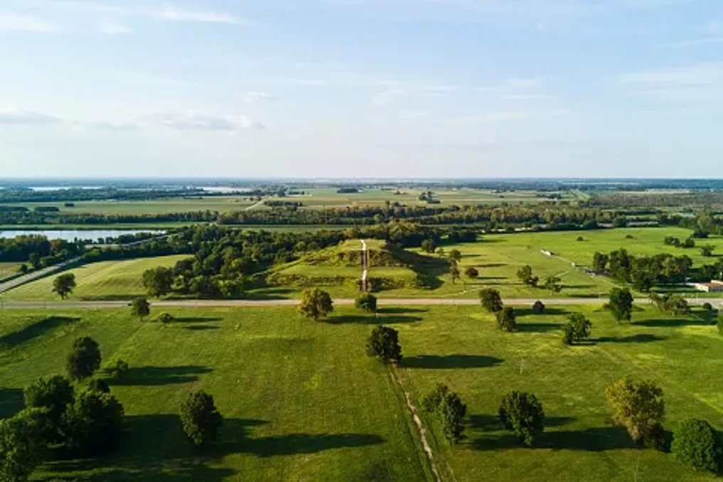
Imagine a view from the top of a massive earthen mound, overlooking a landscape that was once home to one of North America's largest cities. About a thousand years ago, this area, located near the Mississippi River, was inhabited by homes, ceremonial grounds, bustling public plazas, and thousands of people leading their daily lives.

Today, much of this city is hidden beneath the surrounding landscape. However, its massive grassy mounds, ancient gathering places, and archaeological remains are still available for study at the Cahokia Mounds State Historic Site in Illinois.

Located near Collinsville, outside of St. Louis, Missouri, Cahokia was once a thriving indigenous urban center. During its peak, roughly between 1050 and 1150 AD, it is estimated that between 10,000 and 20,000 people lived there. Its outstanding earthworks and carefully organized settlement structure made it one of the most significant pre-Columbian cities in North America.

In 1982, Cahokia was designated a UNESCO World Heritage site, and it is now a fascinating destination for travelers interested in the history, archaeology, and ancient landscapes of the American Midwest. Although much of the former cityscape is no longer visible, there is much to discover on foot.

Key Attractions of Cahokia

No visit to Cahokia is complete without seeing Monks Mound—the largest prehistoric earthwork structure in America. This enormous flat mound covers about six acres and rises approximately 30 meters above the surrounding terrain. It was built by generations of Cahokian residents who transported and stacked countless baskets of earth to create its impressive terraces.

Today, visitors can climb the stairs to the top, where the elevated position offers a different perspective on the archaeological site and the surrounding landscape. From here, it is easier to appreciate the scale of Cahokia and imagine what its central district looked like at the height of the city's life. The contrast between the ancient earthworks and the modern St. Louis urban area creates a particularly striking view.

It is recommended to allocate time to explore the base of the mound and the adjacent paths, rather than treating the ascent as a quick photo stop. Another important spot is the Grand Plaza—a vast open space that once served as the center of Cahokia's public life. This plaza was intentionally leveled and surrounded by significant structures, including several earth mounds. It provided a venue for gatherings, ceremonies, and other community events.

Today, the open landscape allows for the study of the ancient city's layout at a slower pace. Walking through this area, visitors can see how the mounds and public spaces were situated relative to each other. It is also one of the best places to grasp the colossal scale of the settlement; what initially appears as a cluster of grassy hills gradually reveals itself as a meticulously organized urban landscape.

Woodhenges and the City Perimeter

One of the most intriguing features of this site is Woodhenge—a reconstructed circle of large wooden posts associated with solar observation. Archaeologists believe the original structures were used to mark important solar events, including solstices and equinoxes. These observations helped Cahokian residents track seasonal changes and organize aspects of their agricultural and ceremonial calendars. The reconstructed wooden circle gives visitors a tangible sense of what this structure might have looked like a century ago.

If your visit coincides with a seasonal solar event, it is worth checking if any special interpretations or events are scheduled. Otherwise, Woodhenge remains a worthwhile stop for anyone interested in ancient astronomy and the relationship between early societies and nature.

Beyond the main monuments, Cahokia is a place worth exploring on foot. The area includes several walking trails that guide visitors through different parts of the archaeological landscape. Along the way, you may encounter additional mounds, open meadows, and traces of a huge wooden palisade that once encircled the city's central district. The original palisade stretched approximately two miles and was repeatedly rebuilt throughout Cahokia's history. Although much of the structure no longer survives, its archaeological trace helps researchers understand how the city was organized and defended.

For those who enjoy combining history with outdoor recreation, the trails offer a more relaxed way to experience the site. They also provide an opportunity to appreciate the surrounding natural landscape, especially the prairie vegetation. Comfortable walking shoes, sunscreen, a hat, and drinking water are recommended, especially during warmer months.

For a better understanding of what is seen outdoors, take time at the Cahokia Mounds Interpretive Center. The center provides information about the people who built the city, their daily lives, agricultural practices, and the archaeological discoveries that helped reconstruct Cahokia's history. However, visitors should know that the cultural exhibition galleries are currently closed while the site reviews its collections and continues consultations with descendant Native communities.

The vestibule, which includes a model of the site, a canoe exhibit, a temporary display, a gift shop, and visitor amenities, is open from Wednesday to Sunday from 9:00 AM to 3:00 PM according to current visitor information. It is advisable to check the official website before visiting, as access to exhibits and amenities may change.

If you prefer to explore with someone knowledgeable about the site's history, consider joining a guided tour. Cahokia currently offers free guided tours covering Monks Mound and the Grand Plaza. The published schedule lists a Monks Mound tour at 10:00 AM and a Grand Plaza tour at 1:00 PM, from Tuesday to Sunday. Tours last about an hour. Advance registration is required, so contact the site before visiting to confirm availability and arrangements.

A guided tour can add valuable context to the landscape, especially when it comes to understanding the purpose of individual mounds and the significance of various city spaces.

The Cahokia Mounds State Historic Site is located at 30 Ramey Street in Collinsville, Illinois, approximately 13 km from downtown St. Louis, Missouri. Its proximity to St. Louis makes it an accessible day trip for travelers exploring the city and the wider region. For the latest information on operating hours, tour bookings, and visitor updates, please refer to the official Cahokia Mounds website.

Cahokia may no longer be the bustling city it once was, but its preserved monuments offer an exceptional opportunity to explore a little-known chapter of American history. From climbing Monks Mound to walking through the Grand Plaza and standing among the reconstructed Woodhenge posts—a visit allows one to view the scale and ingenuity of this ancient civilization from a new perspective. For travelers passing through the American Midwest, it is a fascinating detour, offering something entirely different from the region's more conventional city attractions.
Similar stories

Ciudad Perdida: Ancient Archaeological Site in the Colombian Jungle
Read more
getaway.co.za

Ciudad Perdida: Ancient Archaeological Site in the Colombian Jungle

Deep within the Sierra Nevada de Santa Marta tropical forest in Colombia stand ancient stone terraces amidst tall trees, rushing rivers, and misty mountains. This outstanding archaeological site, known as Ciudad Perdida or the Lost City, offers insight into the achievements of the Tayrona civilization and the indigenous heritage that continues to shape the region.

This multi-day trek passes through the tropical forest, crosses rivers, and follows steep mountain trails before reaching a network of stone platforms built centuries ago. However, Ciudad Perdida is more than just a remote archaeological find. Local communities call it Tayrona, and it is located on ancestral lands where cultural traditions, spiritual beliefs, and environmental stewardship are closely intertwined with the land.

Ciudad Perdida is situated on the northern slopes of the Sierra Nevada de Santa Marta, a mountain range that rises sharply from the Caribbean coast of Colombia. Archaeologists generally date the earliest settlement of the site to the seventh or eighth century, although its development continued for several centuries.

Architecture and Settlement Structure

Built by the ancestors of the region's indigenous people, Tayrona became an important center in a wider network of settlements connected by mountain trails. Its elevated position above the Buritaca River basin placed it in a landscape of exceptional ecological diversity, where tropical forests meet changing mountain climates.

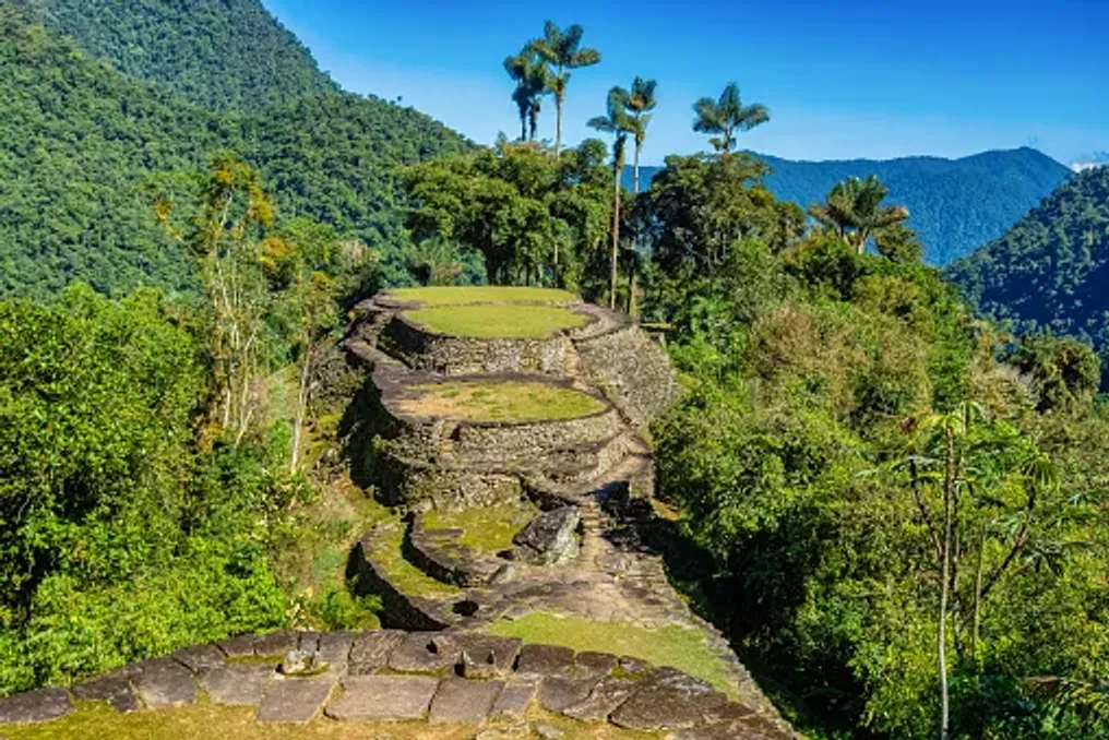
The settlement was not a city with monumental stone palaces. Instead, its architecture reflects a deep understanding of the terrain, including carefully designed terraces, stone staircases, retaining walls, and circular platforms adapted to the steep hillsides.

Over 200 archaeological structures have been identified at the site. The stone terraces supported round houses built from perishable materials such as wood and thatch, while paved paths connected different parts of the settlement.

The builders also developed systems for rainwater management and slope stabilization. Retaining walls supported the terraces, and stone pathways helped link residential areas, public spaces, and other structures on uneven terrain.

Rather than leveling the landscape, the builders worked in accordance with its natural contours. The result was a complex arrangement of platforms and paths that merge with the surrounding forest, demonstrating the engineering skills and ecological knowledge of the people who lived there.

Discovery and Scientific Study

Although local communities knew about the region and its history, Ciudad Perdida attracted widespread archaeological attention only in 1975 when remnants were discovered by individuals searching for pre-Columbian artifacts. This discovery followed a period of looting that damaged archaeological sites throughout the Sierra Nevada.

Subsequent archaeological expeditions documented the settlement, and the Institute of Anthropology and History of Colombia, known as ICANH, began a program of research, conservation, and restoration in 1976. This work helped establish Tayrona as one of Colombia's most important archaeological sites. Its terraces and paths provide valuable evidence of how communities organized settlements, managed steep topography, and maintained connections in the mountainous region.

Today, conservation remains a central element of site management. The stone structures are subject to heavy rainfall, vegetation growth, and human activity. Their protection requires careful visitor management and respect for the broader landscape.

Walking among the terraces offers a different experience compared to visiting archaeological sites dominated by monumental buildings. At Tayrona, the ruins are integrated into the forest, and the structures are interspersed with vegetation, uneven ground, and changes in elevation.

Circular foundations indicate where houses once stood, and larger platforms suggest areas used for public events and daily life. Stairs connect different levels, and paved paths show how people moved through the settlement.

Most information about the city's history comes from archaeological data rather than surviving written records. Therefore, the terraces are more than picturesque ruins; they offer clues about a society whose achievements were closely tied to the surrounding landscape.

Cultural Significance and Management

Ciudad Perdida is located on the ancestral territory of four indigenous peoples: the Kogi, also known as Kaggaba; the Arhuaco, or Iku; the Wiwa, and the Kankuamo. These communities maintain cultural, spiritual, and historical ties to the Sierra Nevada de Santa Marta. Their connection to the mountains extends beyond individual archaeological sites to encompass rivers, forests, peaks, and broader territories that sustain their traditions and way of life.

For these communities, the Sierra Nevada is not merely a scenic mountain range. It is part of a living cultural landscape where the health of the natural environment and the well-being of its inhabitants are closely interwoven. Consequently, Tayrona cannot be viewed simply as an abandoned city. Its importance continues through the living heritage of the indigenous peoples, who recognize the landscape as part of their ancestral world.

The Sierra Nevada is a place where environmental conservation and indigenous beliefs are closely linked. Traditional authorities continue to emphasize the importance of caring for the land and respecting sacred sites.

In October 2026, this interconnectedness was reflected in the temporary closure of the archaeological park. At the request of traditional indigenous authorities, ICANH announced that the site would be closed from October 1st to 15th to allow the land a period of rest and time for internal spiritual practices. The park subsequently reopened to visitors on October 16, 2026, with regular operating hours of 7:00 AM to 3:00 PM. This decision illustrates why access to Tayrona cannot be understood solely from a tourism schedule: the cultural and spiritual practices of the indigenous peoples are a vital consideration in site management.

Travelers can approach this experience with greater understanding by listening to authorized guides, adhering to local protocols, and recognizing that visiting an archaeological site does not mean the entire surrounding area is open for unrestricted exploration.

Journey to the Lost City

Reaching the Lost City requires significantly more effort than visiting a typical attraction. The journey usually begins in Santa Marta, a coastal town that serves as the main base for organizing treks into the Sierra Nevada. From Santa Marta, travelers travel by road to the rural settlement of Machete Pelao, also known as El Mamei, from where the route begins. The trail passes through forested hills, river valleys, and rural communities before reaching the archaeological park.

Most routes take four days round trip, although options ranging from three to six days may be available depending on the operator and itinerary. The hike involves humid conditions, steep ascents, muddy trails, and river crossings. Heavy rains can make certain sections particularly challenging.

Accommodation is typically provided in basic camps along the route, where tourists can rest, eat, and prepare for the next day. This experience differs greatly from a standard vacation, demanding physical exertion and readiness to move at the pace of the landscape.

One of the most memorable moments of the journey is approaching the archaeological settlement closer to the end, as tourists ascend approximately 1200 stone steps to the terraces. This climb serves as a fitting introduction to the city itself. After days spent navigating forest trails and crossing rivers, the stones lead to a network of meticulously formed platforms, winding paths, and green slopes.

It is best to explore the site slowly. Take time to observe the circular foundations, the layout of the terraces, and how the vegetation surrounds the archaeological remains. The setting helps visitors appreciate the practical difficulties faced by the builders and the scale of their achievements.

After touring the ruins, tourists return along the same general route to the start of the trail. Good preparation, appropriate footwear, and a realistic understanding of the terrain are necessary. The journey to Ciudad Perdida offers more than just the destination itself. The trail traverses tropical ecosystems shaped by variations in altitude, precipitation, and relief. Forest canopies, tangled roots, streams, and riverbanks create a constantly changing backdrop for the walk.

River crossings are part of the route, and conditions can change after heavy rain. Tourists must follow the instructions of their guides and avoid attempting crossings when water levels or currents make it unsafe. The birdlife, tropical vegetation, and sounds of running water complement the experience, although encounters with wildlife are never guaranteed. The forest is a living ecosystem, not a set piece created for visitors.

The route also passes through indigenous communities and territories, offering an opportunity to understand that the mountains are not desolate wilderness. Communities continue to live and work in the region, maintaining relationships with the land that predate modern tourism. Traveling with an authorized guide helps visitors navigate the route safely and provides context about the landscape and its cultural significance. Local guides, cooks, and other trekking staff also contribute to the visitors' experience, making responsible tourism an opportunity to support the people working in the region.

Visitors should ask permission before photographing people, homes, or culturally significant activities and respect any restrictions posted along the trail. The climate in the Sierra Nevada is humid and can be very rainy, so even a favorable forecast should not be considered a guarantee of dry conditions. Trails can become slippery, and the combination of heat, humidity, and steep terrain can make walking exhausting. Sufficient time must be allocated for the entire trek, provisions for rest must be made, and the route chosen must match your fitness level.

Tourists should book through authorized operators and check the latest access information before departure. The trail is not clearly marked throughout, and independent hiking is prohibited. A certified guide is required, so visitors must arrange their trek in advance and confirm what is included in the package. The announced reopening on October 16, 2026, is an important current update but should not be taken as a guarantee of uninterrupted access in the future. Temporary closures can occur for cultural and spiritual reasons, preservation, safety, or other operational reasons. Before leaving, check the latest announcements from ICANH and confirm arrangements with an authorized tour operator. The published park hours are from 7:00 AM to 3:00 PM, but multi-day trekking and accommodation must be arranged separately. Respecting closures and local instructions is part of responsible travel, not an inconvenience to be bypassed. The remote location of the site does not negate the responsibilities associated with visiting a protected cultural landscape. Stay on marked trails, avoid climbing on or moving stones, take all trash with you, and follow guidelines regarding photography and restricted areas. Tourists must also acknowledge that indigenous peoples have a voice in how their ancestral territory is cared for and used. Choosing an authorized operator, following the guide's instructions, and showing respect to local residents can help make this experience more respectful for all participants.

Derinkuyu Underground City in Cappadocia: A Hidden Settlement Beneath Volcanic Landscapes
Read more
getaway.co.za

Derinkuyu Underground City in Cappadocia: A Hidden Settlement Beneath Volcanic Landscapes

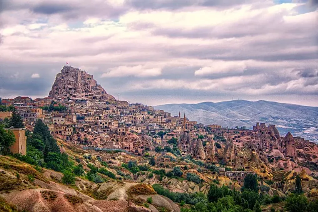
Located amidst the characteristic volcanic landscapes of central Turkey is an outstanding settlement that elevates the concept of life on Earth to a new level. The underground city of Derinkuyu descends deep into the earth, revealing a network of narrow tunnels, rooms carved into the rock, storage areas, and ventilation shafts excavated from the region's soft volcanic rock.

The unusual topography of Cappadocia is largely due to ancient volcanic activity. Eruptions in the surrounding area covered the landscape with ash, which over time hardened into a relatively soft rock known as tuff. Over time, erosion formed the region's characteristic valleys, pillars, and fairy chimneys, and the rock itself provided accessible material for constructing homes, churches, and underground spaces.

For the communities settled here, this geology allowed them to build not only on the surface. Instead of constructing everything from stone or wood, people could excavate rooms directly into the rock, gradually creating interconnected spaces beneath their settlements.

Derinkuyu is among the largest and deepest underground complexes in Cappadocia. The Turkish Ministry of Culture and Tourism records a depth of about 85 meters, although only a portion of this vast complex is accessible to visitors today.

This underground city is part of a wider network of subterranean settlements throughout Cappadocia, where underground architecture became an important response to environmental conditions and periods of instability in the region. Derinkuyu was not merely a labyrinth of escape tunnels; its chambers demonstrate the practical needs of a community that required shelter underground for extended periods.

Functionality and Religious Significance

The excavated spaces include stables, cellars, food storage areas, kitchens, communal areas, and religious sites. Among the features identified by Turkish museum authorities is a missionary school, and the church, baptismal area, and other religious structures reflect the significance of Christianity in the settlement's history.

The location of these areas indicates that the underground city was designed to support daily activities as well as emergencies. Animals could be kept in designated areas, food and supplies stored, and communal areas allowed people to gather away from the open landscape above.

The construction also reflects a practical understanding of movement: stables and other functional rooms were located on upper levels, facilitating the descent of animals underground. Kitchens and storage areas were similarly organized to ensure the transport of food and other necessities.

Although popular accounts sometimes describe Derinkuyu as a city where thousands of people could live underground for months, the exact capacity and circumstances of its use remain difficult to establish. It is clear only that its scale and amenities made it significantly more complex than just a refuge.

Ventilation System and Safety

One of the most impressive elements of Derinkuyu is its ventilation system. The main shaft extends to the surface, helping to circulate air through the underground levels. This system was vital in the complex structure, where closed chambers and narrow passages could otherwise become uninhabitable for long stays.

The main ventilation shaft also served as a well. Access to water would have been critically important for anyone sheltering underground, especially when exiting the settlement was unsafe. Turkish museum information describes a shaft approximately 55 meters deep, connecting to the surface and serving this dual function.

The broader network includes numerous passages and shafts, although the exact location and number of ventilation openings vary in published sources. All these elements demonstrate how the settlement builders managed the challenges of living underground.

Safety was also a central concern. Large circular stone doors were installed at strategic points along some passages. These heavy barriers could be sealed from the inside, helping residents block access to sections of the settlement when a threat arose.

The tunnels themselves were often narrow, with some passages allowing only one person to pass at a time. While such planning may complicate navigation through the complex today, it also helped restrict movement within it. The combination of hidden entrances, winding corridors, and defensive barriers created a network where access could be controlled. Instead of relying on a single fortified wall, the underground city utilized its layout and surrounding rock for defense.

History and Discovery

The exact origin of Derinkuyu remains uncertain. Some accounts date the earliest phases of Cappadocia's underground settlements to antiquity, while later communities expanded and adapted them over many centuries. Therefore, it is more accurate to understand Derinkuyu as a place shaped by successive generations, rather than a city built in a single period.

Christian communities played an important role in the region's underground history. UNESCO notes that the rock-cut settlements and underground cities of Cappadocia, including Derinkuyu and nearby Kaymakli, served as a refuge during Arab invasions into Byzantine territory. These underground spaces provided protection from raids and other threats, allowing residents to hide with provisions and, if necessary, livestock. Their use was not necessarily continuous: people could enter the underground complex when circumstances demanded and return to surface settlements when it became safe.

The religious spaces of the settlement provide additional evidence about the communities that used and adapted them. However, the history is more complex than a single narrative of persecution or one group of builders. The development of Derinkuyu reflects the changing needs of people living in a region that experienced shifts in political, cultural, and religious views.

For centuries, parts of Cappadocia's underground world remained unnoticed. Derinkuyu came to the attention of modern times in 1963 when a local resident reportedly discovered a hidden room during home renovations. Subsequent investigation revealed that this chamber was connected to a much larger underground network. This discovery drew attention to the scale of the underground settlement and the volume of preserved architecture. The site was subsequently excavated and opened to visitors in the 1960s.

Today, only a portion of Derinkuyu is available to the public. According to Turkish museum authorities, about 10% of the underground city is open to visitors, giving an idea of a complex that extends far beyond the areas explored during a typical tour.

Its rediscovery also highlights how much of Cappadocia's history is preserved beneath the modern landscape. The region's archaeological heritage is not limited to structures visible from its valleys and roads; it is also within the rock itself.

Visiting Derinkuyu offers a completely different experience compared to exploring Cappadocia's open valleys and viewpoints. The route leads through dimly lit chambers, gentle passages, and stairs descending into the rock. Along the way, visitors can see evidence of the settlement's organization, including narrow corridors, storage rooms, and characteristic stone barriers.

The atmosphere is part of the experience. The temperature, limited light, and enclosed space create a sharp contrast with the bright, open landscapes above ground. Viewing a passage or descending into a shaft also provides insight into the labor involved in carving and maintaining such a vast network by hand.

This experience is not suitable for everyone. Some tunnels are narrow and steep, and visitors who are uncomfortable in confined spaces or have limited mobility may find certain parts of the route challenging. Those who visit should follow marked routes and any instructions from site personnel.

Derinkuyu is located in the Nevşehir province, approximately 30 kilometers from the town of Nevşehir. It can be combined with visits to other Cappadocia attractions, including rock-cut churches, cave dwellings, and characteristic volcanic landscapes.

Derinkuyu reminds us that some of the most remarkable architectural achievements were not created to dominate the landscape, but to merge with it. Its interconnected chambers, ventilation shafts, and defensive passages show how communities transformed soft volcanic rock into a place capable of providing shelter, storing supplies, and supporting daily life.

The underground city also serves as a reminder of the uncertainty surrounding much of the past. Its exact origins, full scope, and settlement patterns continue to be subjects of research, while the preserved spaces offer tangible proof of the ingenuity required for life beneath the surface.

For travelers exploring Cappadocia, Derinkuyu adds another dimension to the region celebrated for its extraordinary beauty. Beneath the fairy chimneys and cave hills lies a world shaped by geology, ingenuity, and the enduring human need for security.

Ancient stone settlement in Kenya built without mortar
Read more
getaway.co.za

Ancient stone settlement in Kenya built without mortar

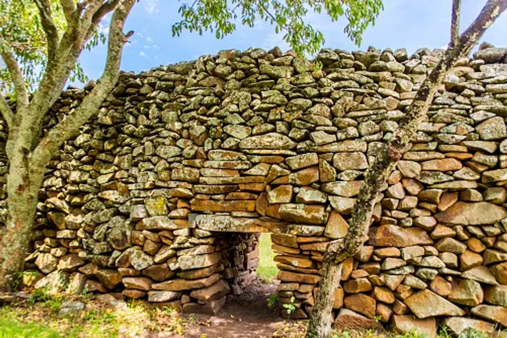
In western Kenya, amidst green landscapes, lies the archaeological site of Timlich Ohinga. These majestic stone walls bear witness to the life, labor, and livestock protection of communities that existed centuries ago. This ancient settlement was constructed without the use of cement or mortar, demonstrating an impressive understanding of construction techniques and communal living.

Located near Lake Victoria, Timlich Ohinga offers a unique glimpse into Kenya's past and is one of the most striking examples of traditional dry-stone architecture in Africa. The settlement is presumed to have been founded in the 16th century, but subsequent generations of communities continued to use and maintain its enclosures for many centuries. In 2018, this site was included in the UNESCO World Heritage List in recognition of its cultural and archaeological significance.

The name is derived from the Dholuo language and is generally translated as 'fearsome dense forest.' The word 'ohinga' refers to a settlement or enclosure, reflecting the unique character of this place. The stone walls served to protect the communities and their livestock, and the settlement's layout reflected the relationships between families and broader social groups.

One of the most striking aspects of Timlich Ohinga is its construction. Builders selected stones of various shapes and sizes, connecting them into a system of interconnected elements without using cement or mortar. The walls featured a three-part structure: outer and inner layers rested on a central section made of smaller stones. This method allowed for the creation of stable structures capable of withstanding the elements.

Some walls reach heights of about 4.5 meters and have a thickness of approximately one meter, which is an outstanding achievement given the available building materials and methods. The settlement includes several large enclosures, such as Kochieng, Kakuku, Koketch, and Koluoch. Inside these enclosures, archaeologists have discovered smaller sections, traces of former dwellings, livestock areas, and evidence of craft activities.

These elements indicate that Timlich Ohinga was not only a defensive fortification but also an organized community where people lived, raised animals, and engaged in daily activities. The settlement provides important insights into migrations, cultural exchange, and changing settlement patterns in the Lake Victoria basin.

Over time, various communities with different linguistic characteristics resided at the site, adapting and utilizing it. Archaeological finds, including pottery and ironworking traces, help researchers understand how people utilized local resources and interacted with neighboring groups. Furthermore, the settlement demonstrates how communities could organize themselves without relying on a single central authority; social ties, lineage, and shared responsibilities shaped the way of life and environmental maintenance.

For travelers interested in Kenya's history outside its well-known wildlife reserves, Timlich Ohinga offers a valuable cultural experience. The site is located approximately 46 kilometers northwest of the town of Migori, in western Kenya, near the Lake Victoria region. Visitors can walk among the preserved stone enclosures, observe the unusual construction methods, and imagine the daily life that once unfolded behind these walls. The surrounding vegetation enhances the feeling of immersion in a place shaped by centuries of human activity.

The site is managed by the National Museums of Kenya, which works to preserve its archaeological remains and cultural value. Tourists are advised to respect the structures, follow on-site instructions, and avoid damaging the stones or other archaeological objects. Timlich Ohinga serves as a reminder that exceptional architecture does not always require complex tools or modern materials. Through careful stone placement, collective knowledge, and long-term maintenance, its builders created a settlement that has survived for centuries. Today, preserving this place means protecting not only its walls but also the history, traditional knowledge, and community connections it represents. For all who study Kenya's cultural heritage, Timlich Ohinga opens up a fascinating journey into the past, visible in every carefully placed stone.

Popular