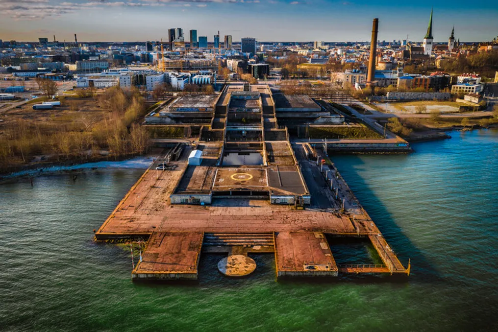
Starting from the end of Mere Boulevard in Tallinn, Linnahall presents itself as an extensive and low structure of limestone and concrete, situated between the Old Town and the bay. This building was intentionally constructed below the medieval profile line to ensure that the spires remained visible from the water. The sides are accessible via wide staircases leading to a paved floor, functioning as a public square. From there, a series of terrace steps descends towards a small pier, a helipad, and the open waters of the Gulf of Finland. Beneath this surface are located an amphitheater with a capacity of 4,200 people, a 6,000 square meter foyer, an ice rink, cafes, a bowling alley, and a recording studio.
The building was inaugurated in the summer of 1980 under the name Palace of Culture and Sports V. I. Lenin, coinciding with the sailing regattas of the Moscow Olympics, which Tallinn hosted as a city without sea access. It is part of more than 120 projects planned within the city's Olympic program, alongside the yachting center in Pirita, the TV Tower, the Olympia Hotel, and a new airport terminal.
The architectural design was signed by Raine Karp and Riina Altmäe, who worked at the state institute of projects Eesti Tööstusprojekt. The interiors were designed by Ülo Sirp and Mariann Hakk, while the structural engineering was handled by Ago-Allan Kuddu. A few years after its inauguration, the project received an award at the Interarch '83 congress of the International Union of Architects, and in 1984, the State Prize of the USSR. Construction occurred simultaneously with other Olympic works, facing difficulties such as labor shortages and tight deadlines, which resulted in some technical installations located behind the stage remaining unfinished.
Over the subsequent four decades, the building has undergone much smaller changes than the waters before it. When the roof was first opened to the public, the waterfront it reached was largely enclosed during the post-war period, and the opposite side of the gulf belonged to a distinct political context. The entire history of Linnahall lies in the decision of Karp and Altmäe in the mid-1970s: to create a public path extending over a restricted coast, directing towards a sea that the city had long deprived itself of.
Between the water and the sky
Architect Margit Mutso explained that Soviet regulations required any city with more than 400,000 inhabitants to have a pavilion with a capacity of 10,000 spectators. The Olympic construction program, which transformed large parts of the city during the 1970s, served to secure funding from Moscow. The standard provided for a single arena, but the division into a concert amphitheater and an independent ice rink was a choice made by the designers themselves. Later, Karp recalled that the idea persisted largely because there was no client in the strict sense, which gave the architecture team the freedom to build what they deemed correct.
The location imposed its own restrictions. Initially, areas in new residential neighborhoods and in the city center were considered, before the choice fell on the land near the boundaries of the Old Town walls, a decision justified as an act of returning the sea to the city. The area between the Old Town and the port was occupied by a precast concrete factory, a shipyard, and a scattered set of warehouses and repair workshops, and during most of the post-war period, the waterfront between Kopli and the Rusalka monument remained isolated by barbed wire. This port area operated as a restricted military and industrial zone, causing the sea to barely participate in the daily life of the city.
A second set of limiting factors came from the Old Town itself, which was classified as a preservation zone in 1966, under the management of the city's chief architect, Dmitri Bruns. The design team also had the obligation to preserve the view of the medieval city for those arriving by sea, which forced the program of thousands of seats to be distributed across the terrain rather than elevated above it. Since the railway tracks serving the port could not be relocated, the building was extended over them as a pedestrian passage. A wide transport corridor still runs beneath the roof plaza, used by the port railway in 1980 and by trams today.
The program was organized around a central axis, with the lower ice rink facing the city, the amphitheater in the center, and two low wings extending towards the water. The resulting low and axial volume sits on the coastline like a new bulwark, clad in limestone and dolomite brought from the island of Saaremaa. Viewed from the water, the building resembles a large support for the city. Its sloping, grass-covered embankments aimed to integrate it into the surrounding terrain, and original plans included a park around the building—a project that was interrupted due to budget cuts and the Olympic deadline. According to Andres Kurg, Karp liked to compare the result to Japanese Metabolism, while later observers sought parallels in pre-Columbian ziggurats and platforms.
A balcony for the bay
In a city distant from its own waterfront, the most notable feature of the project was the roof. Andres Kurg, an art historian who has studied Linnahall since the early 2000s, describes the roof as a public space that provided access to a shoreline forbidden for much of the Soviet period. Terraces, benches, lighting fixtures, and fountains transformed the ascent into an evening stroll, and the Estonian Architecture Museum defines the roof as a landscape from which the architecture team intended to reveal views of freedom. On clear days, it is possible to see Finland, about eighty kilometers away, across the gulf.
The interior was conceived for a different audience. At its inauguration, the building housed some of the most advanced lighting and sound equipment of the time, in addition to an analog recording studio that remains active. Aivar Mäe, director of the Estonian National Opera, pointed out that the amphitheater was built as an electronic hall, with dry acoustics and minimal reverberation, ideal for amplified sound. Despite its generous dimensions, the last row of seats was only twenty-five meters from the stage. Engineer Jarek Kurnitski considers the space unique in the world, partly because its curved back wall could be opened to form an even larger interior.
This acoustics accompanied all future debates about its fate. In 2016, acoustics specialist Yasuhisa Toyota, whose portfolio includes the Elbphilharmonie in Hamburg, visited the site and positively evaluated the seating arrangement, although he noted that the ceiling would need to be rebuilt. Mutso states that Toyota identified the potential there to become the most important concert hall with natural acoustics in Northern Europe, which would likely require increasing the venue's height. Kurnitski, for his part, questioned what an opera company would do with a space of that size, given that it was never designed for unamplified sound.
Around the amphitheater, the building develops into more than one hundred rooms. A long, curved chapel surrounds the front of the hall, cafes and bars are distributed across several floors, and a ground-floor cafe opens directly onto the water. Mutso attributes the building's initial reputation, both in the Soviet Union and abroad, to this coordinated interior as well as its urban integration, with the furniture and lighting by Sirp and Hakk designed in perfect harmony with the architecture. In the following decades, the space hosted Soviet pop stars, school fairs, flower exhibitions, and political conferences, as well as international artists such as Lou Reed, Philip Glass, and a-ha.
The country's independence altered the financial viability of the building within a few years. Mutso recalls that the public began to prioritize essential expenses, decreasing attendance at concerts. Architectural historian Grete Tiigiste observes that public funding practically disappeared in the 1990s, and the municipality expected Linnahall to generate enough revenue to remain autonomous. Its spaces were thus rented out to bars, nightclubs, party conventions, and Jehovah's Witnesses assemblies. In 1997, Linnahall was classified as state historical property, but the municipal administration began to see it as an impediment to selling valuable waterfront land. When the Saku Suurhall, with a capacity of 10,000 people, was inaugurated in 2001 with support from the municipality and the state, it definitively extinguished the little activity that still existed on the site.
Meanwhile, the waterfront facing the building gained a new meaning. Behind the pavilion, the helipad became the Tallinn terminal of Copterline, with flights connecting the city to the Hernesaari heliport in Helsinki, and a small ferry terminal was added for fast catamarans towards the Finnish capital. The route began operating in 2000 and, around 2005, transported about 75,000 passengers annually. The roof, which previously offered a distant and authorized contemplation of the opposite shore, transformed into a departure point towards it.
The spaces themselves gradually began to close down. The ice rink ceased operations in the spring of 2009, and the last public event took place in December of that year, followed shortly by the closure of the concert hall. Plans to reopen them arose repeatedly without any materializing. In 2016, the municipality and the state agreed to reformulate the complex as a concert hall and convention center, with completion expected in 2019. In 2019, the government supported a proposal to install an opera house in the building, with an estimated cost between 160 and 170 million euros. A year later, the municipality established a partnership with Tallink Grupp and Infortar for a 300 million euro development combining a convention center, passenger port, hotel, and shopping center, but this initiative stopped due to the pandemic. Concurrently, a 2016 expert assessment recorded serious infiltration damage caused by leaks in the roof, although it indicated that the load-bearing structure was in satisfactory or even good condition. For over a decade, the interior was only opened on specific occasions. The most notable was in 2019, when Christopher Nolan filmed the initial sequence of Tenet inside the amphitheater, adapted to represent an opera house in Kyiv. The roof, on the other hand, never stopped being used.
Threshold
In March 2026, the Mayor of Tallinn, Peeter Raudsepp, argued that the renovation and maintenance of the building exceeded the financial capacity of taxpayers, arguing that Linnahall should be demolished to make way for a new urban landmark. Anita Staub, director of built heritage at the National Heritage Council, contested that a legally protected monument could not be removed in this manner. She referred to a technical engineering report commissioned by the municipality the previous year, which attested that parts of the load-bearing structure were in good condition. Aet Ader, president of the Estonian Architects Association, added that the foundations showed no signs of settlement and suggested reflection on the meaning of a renewal for a work of this magnitude, at a time when European practice increasingly favors the maximum conservation of existing material. Interestingly, in the same weeks, an institutional presentation aimed at foreign investors was held.