Paricatuba Ruins, a historic village near Manaus, receive a new tourist route
Read more
Viagem e Turismo
viagemeturismo.abril.com.br

Paricatuba Ruins, a historic village near Manaus, receive a new tourist route

On the banks of the Rio Negro, in the village of Paricatuba, Amazonas state, are the Paricatuba Ruins—the remains of a magnificent century-old building. This village, recognized as a historical and cultural heritage site of the state, is located in the municipality of Iranduba, approximately 40 kilometers from Manaus.

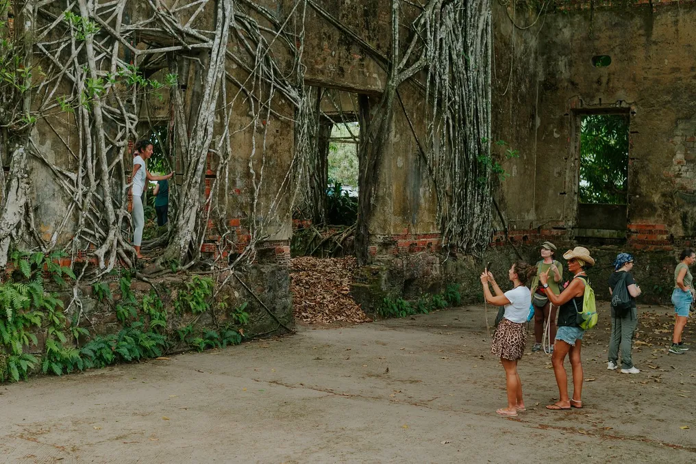
Special attention is drawn to the stone structure overgrown with the huge roots of kapok trees—trees that embrace the walls and help them remain stable, creating a unique landscape. Construction began in the late 19th century with the aim of housing a hotel for Italian immigrants. Materials imported from Europe were used for the building's construction, which were considered expensive and valuable at the time.

Throughout the 20th century, this place served as a venue for various educational initiatives and was also converted into an isolation hospital for the compulsory treatment of people with hansen's disease (an infectious disease previously known as leprosy). Around the mid-1980s, construction was abandoned and overtaken by Amazonian vegetation, leading to the formation of the current landscape.

In September of this year, the village of Paricatuba received a full-fledged tourist route. The Paricatuba Tourist Trail was launched on September 26, 2026, as part of the Viva Paricatuba project, implemented by Impact Hub Manaus in collaboration with village residents and the Paricatuba Community Association.

Along with the launch of an official website containing information for travelers, the new tourist route included the installation of bilingual road signs and information stands throughout the village. These structures mark historical attractions such as the old morgue, the church, and one of Paricatuba's oldest houses.

The century-old ruins of the settlement have also undergone changes. A museum has been opened inside the ruins, displaying photographs, traditional regional artifacts, and old community items, all preserved and presented in glass display cases and on display tables.

Another piece of news was the creation of an open art mural called Muro Parikás, executed by graffiti artist and cultural producer Valdemiro Nascimento. This work combines illustrations of local animals and fruits, which were developed, in part, collectively based on discussions with the Paricatuba community.

The inauguration was also marked by the release of the comic book 'Paricatuba, Village of a Thousand Stories,' created by Romax Mascarenhas, an artist belonging to the Mauricio de Sousa Produções team. The work tells the story of a boy from Manaus who visits his grandmother in the village, and it can be purchased on site.

The easiest way to get to the village of Paricatuba is from Manaus. From the capital of Amazonas, one must cross the Rio Negro Bridge and travel along the Manoel Urbano Highway (AM-070) to kilometer 21 in the municipality of Iranduba. The trip by car or bus takes about 40 minutes to enter the village.

In the village itself, visitors can arrange tours of the attractions led by local residents who tell tourists the history of this historic place. For those planning to stay longer, the region also offers community guesthouses and other accommodation options, as well as restaurants and establishments serving regional breakfast with typical Amazonian flavors.
Similar stories

Square and Tourist Point Project in Piodau by Branco-DelRio Arquitectos
Read more
archdaily.com.br

Square and Tourist Point Project in Piodau by Branco-DelRio Arquitectos

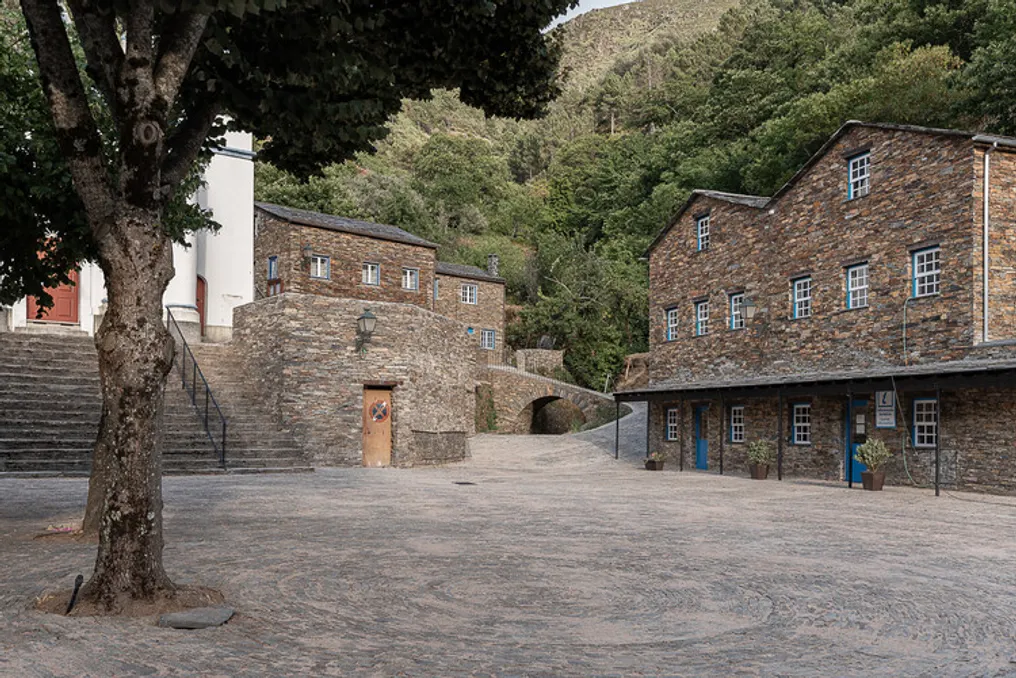
The architectural firm Branco-DelRio Arquitectos presented a project for a square and a tourist point for the village of Piodau. This village is located on a steep cliff and has an amphitheater shape, consisting of slate houses through which pass steep and narrow streets also paved with slate.

The Conego Manuel Fernandes Nogueira Square, located at the lowest part, is the only open, horizontal, and spacious area that serves as the main entrance to the village. Residents and many tourists enter through this square throughout the year, and necessary loading and unloading operations for supplying this isolated location in Serra de Assor are carried out here.

MIAA - Iberian Museum of Archaeology and Art and Carrilho da Graça Architects in Abrantes
Read more
archdaily.com.br

MIAA - Iberian Museum of Archaeology and Art and Carrilho da Graça Architects in Abrantes

The city of Abrantes is a significant point, both materially and historically, within a larger geographical area. This importance stems from its geo-strategic location, resulting from a promontory situated at the geometric center of the territory, delimited by geopolitical conventions and located at the transition between two landscapes of different morphologies.

Abrantes has always functioned as a point of observation and reference, serving as a fortified outpost and an obligatory route, whether in times of peace or conflict. On this fundamental terrain, human presence established its location, intrinsically linked to the surrounding environment.

The Castle, being the initial nucleus of the city, occupied the primary position, dominating the curve of the Tagus River that surrounds the promontory. The castle walls extended to organize civil and religious life, following the valleys and descending towards the river. Near the river, on the alluvial plain, the first religious communities emerged, close to the movement of work and commerce, but vulnerable to seasonal flooding risks from the Tagus.

Due to poor sanitary conditions and the occurrence of plagues, religious orders were forced to leave the plain in search of greater topographical safety, settling on the outskirts of the city. These new installations appeared at the extremes of the urban axes, which were previously centered on the Castle and the two parishes.

The Dominican Convent of São Domingos was established on the Rossio plateau, outside the walls (current Republic Square). This 16th-century building sat on a section of Vauban-style wall, atop a steep slope on the southern end of the promontory where Abrantes is located. After losing its monastic function, the convent was used by military personnel and students, and its church was converted into a public library, while most of the other spaces were ceded to the Polytechnic Institute of Tomar.

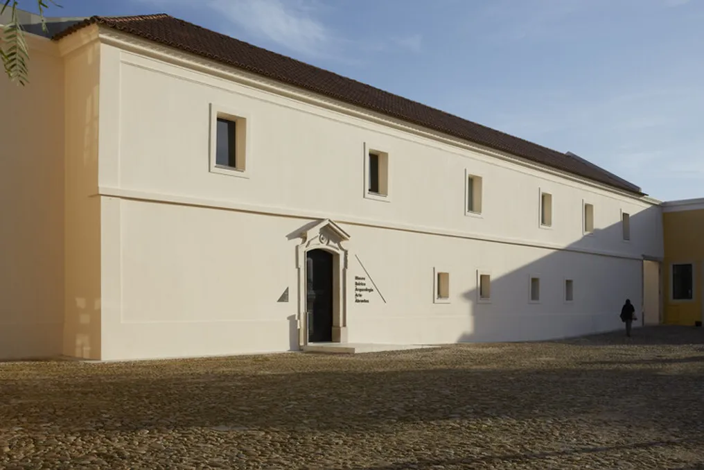
Currently, the convent houses the MIAA - Iberian Museum of Archaeology and Art of Abrantes, which occupies the wings not used by the library. The MIAA project is based on the understanding that construction in the territory is part of it, being simultaneously an external object and a record of events and periods that shape the landscape.

Starting from a dialectic aimed at clarifying the built complex, the project considers the programmatic and logistical requirements necessary to create museological conditions in a historical building that required care. The objective was to find a solution that highlighted the heritage value, resuming an organization that referred to the original spatial arrangement.

The convent's spaces, arranged around the original cloister, revealed unexpected architectural quality and flexibility after the removal of cells by previous occupants. This reinforced the need for the restoration, rehabilitation, and infrastructure of the building to be guided by formal sobriety and functional occupation adapted to the structural and spatial characteristics of the complex.

The ground floor of the convent was mainly dedicated to technical services and support for the museum's operation. On the first floor, exhibition spaces are distributed for specific collections and funds deposited at the Abrantes City Council.

The heritage assessment of the building allowed for the recovery, in a practical and surprisingly advantageous way in terms of architectural quality and functional flexibility, of the original concept of the Dominican Convent. Thus, the MIAA subtly assumes a new centrality in the city of Abrantes, located on top of the hill.

Dinosaur Footprints Discovered at Paleontological Site in Chapada das Mesas, Maranhão
Read more
g1.globo.com

Dinosaur Footprints Discovered at Paleontological Site in Chapada das Mesas, Maranhão

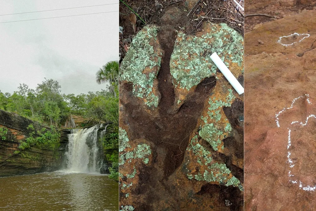
The Chapada das Mesas region, located in southern Maranhão, known for its waterfalls, canyons, and natural pools, also holds important vestiges of prehistory. In Fortaleza dos Nogueiras, visitors have the opportunity to see fossilized dinosaur footprints preserved in rocks at a paleontological site situated in Tangará Ecopark.

This paleontological site at Tangará Ecopark contains records where researchers identified a minimum of 78 dinosaur footprints, spread across seven areas of rocky outcrops.

The discovery was the subject of a scientific study published in June 2025 in the international journal Italian Journal of Geosciences. Scientists from the Federal University of Maranhão (UFMA) and other Brazilian institutions participated in the research.

The footprints were located in early 2024 during a tourist attraction survey conducted along the banks of the Mosquito River, in Fortaleza dos Nogueiras. A tourism professional from the Federal University of Maranhão (UFMA) noticed unusual marks on the rocks and sought out Professor Manuel Medeiros, who belongs to the Biology Department of the university.

After a technical inspection, researchers confirmed that the marks were indeed fossilized dinosaur footprints. This finding generated significant international repercussion.

The investigation involved a multidisciplinary team composed of researchers from UFMA, the Federal University of Rio de Janeiro (UFRJ), the Federal University of Rio Grande do Sul (UFRGS), and other entities. The results were published in the scientific article titled 'Jurassic dinosaurs from Brazil: the footprints from Parnaíba Province, Mosquito Formation,' which was part of a special edition of the Italian journal dedicated to 200 years of scientific studies on dinosaurs.

The research detailed five distinct types of footprints, called morphotypes, presenting variations in size and shape; some of them exhibit three-toed marks and traces of claws.

In addition to its scientific value, the paleontological site has been incorporated into the tourist offerings of Tangará Ecopark. The park's administration reports that visitors can examine the fossilized records through an activity called 'Trilha das Pegadas' (Footprint Trail), which is guided with specialized instruction. This route allows for the observation of the marks preserved in the rocks and knowledge of part of the region's geological history.

The monitored visitation also serves as a conservation strategy, since the fossils constitute a scientific heritage, and access control aims to prevent damage to the surfaces containing the marks of prehistoric animals. Tangará Ecopark recommends that this activity be scheduled and consulted with the park's team in advance.

The park also provides complete infrastructure for those wishing to enjoy other natural tourist spots, such as waterfalls, natural pools, trails, leisure and rest areas, in addition to offering restaurants and accommodation options.

Tangará Ecopark is located in the rural area of Fortaleza dos Nogueiras, a municipality in southern Maranhão, within the Chapada das Mesas tourist area. According to the administration, access is made starting from the municipal headquarters, traveling about 10 kilometers along highway MA-006 and another 4 kilometers on a dirt road to the destination.

To facilitate the journey, it is advisable to check the official location and ask the park staff for directions before starting the trip. The inclusion of the footprints expands the range of attractions in Chapada das Mesas, which is already sought after by tourists interested in natural landscapes, rock formations, and waterfalls. The marks preserved at Tangará Ecopark provide visitors with the chance to learn about a segment of Maranhão's prehistory, adding a historical and scientific appeal to ecotourism routes in the south of the state.

Popular