Exploring the Quiet Corners of the Bred River Valley Beyond the Wine Routes
Read more
Getaway
getaway.co.za

Exploring the Quiet Corners of the Bred River Valley Beyond the Wine Routes

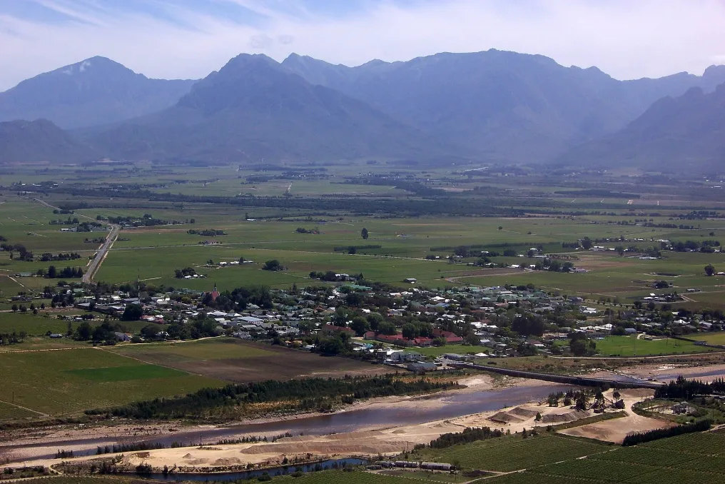
In December, the Western Cape is usually associated with bustling beaches and crowded coastal towns. However, deep in the Bred River valley, an alternative form of summer recreation is offered, featuring mountain landscapes, rural villages, river relaxation, and nature reserves.

Although Robertson and its wineries are well-known names, the valley holds more than just cellars and vineyard lunches. It is worth heading to McGregor, exploring the surrounding reserves, or spending a few days by the banks of the Bred River. Below are some quieter spots worth discovering this summer.

Nestled against the backdrop of the Riversonderend mountains, McGregor is a small village with whitewashed cottages, thatched roofs, and lush gardens. Its quiet streets, galleries, and shops are best explored on foot.

A good time to visit is Saturday morning when the local market gathers homemade food, fresh produce, and handmade goods.

Nearby in the village is the Eseltjiesrus donkey sanctuary, which provides shelter for rescued and forgotten donkeys. Visitors can meet the animals, learn about their care, and support the sanctuary's charitable work. The grounds also feature a coffee shop and a small store.

Approximately 15 kilometers south of Robertson, on the way to McGregor, lies the Vrolikheid Nature Reserve, offering a respite from vineyards and farmland. This reserve is managed by CapeNature and protects rocky hills, indigenous shrubs, and succulents, providing several walking trails.

The 3 km Heron trail passes by two reservoirs and bird observation points, while the more challenging Ruikat trail is an eight-hour hike covering 19 km. The reserve also provides access to the 14 km Bosmantkluf trail between McGregor and Greeton, which crosses the Riversonderend mountains, passing by Oaks waterfall and its pools.

Temperatures can rise quickly in the summer, especially on longer routes. It is recommended to start early, bring enough water, and check trail accessibility before setting out.

The Bred River is one of the valley's main attractions. Stretching about 320 km towards the Indian Ocean, it offers opportunities for swimming, fishing, and kayaking, depending on local conditions.

River accommodation, ranging from campsites to self-catering options, simplifies planning a holiday around the water element. One can spend a day outdoors, have a barbecue, or simply enjoy the surrounding countryside.

Fishing is popular in certain sections of the river, but permit requirements and local rules should be checked in advance. Not all sections are safe for swimming, so it is advisable to ask accommodation owners about suitable access points, currents, and water levels. Swimming should be avoided after heavy rains.

Often viewed merely as a stop on the N2 highway, Stellenbosch deserves more than a quick coffee break. It is worth exploring its historic streets and Cape Dutch architecture, and the surrounding mountains offer numerous opportunities for outdoor activities.

Just outside the town, the Bontebok National Park protects the bontebok and other local wildlife within the Cape Floral Region. Walking trails, cycling, and birdwatching allow exploration of this area.

It is important to note information regarding December 2026: flooding in May damaged park infrastructure, leading to phased reopening. SANParks confirmed in September that six chalets, a campsite, and three trails had reopened. The picnic area and two other trails were still under renovation. Visitors should check the latest information before traveling.

In the Swellendam mountains, the Marloth Nature Reserve features mountain fynbos, native forest, streams, and waterfalls. A 2 km walk to Duivelspoort waterfall passes through native forest to the falls, while the 12 km Platte loop runs along mountain streams and is a more challenging option. Longer hikes, including the ascent of Tweefontein, are also available. Some routes require prior arrangement and a minimum number of participants, so contact CapeNature before visiting. Summer hikes are best done early in the morning.

Bonnievale, Ashton, and the surrounding farming communities offer another reason to explore beyond Robertson. Bonnievale is situated between the Langeberg and Riversonderend mountain ranges, surrounded by fruit farms, vineyards, and agricultural land. It is a good base for exploring the countryside, with opportunities for cycling, fishing, and visiting local producers.

Robertson remains a convenient base, as it is easily accessible to McGregor, Vrolikheid, and Bonnievale, where accommodation and restaurants are located.

Instead of trying to see everything in one weekend, it is better to choose a base and explore from there. Time should be allocated for visiting a farmers' market, an unplanned lunch, or a detour down a country road.

The Bred River valley offers much more than its usual wine route. From the streets of McGregor to the hiking trails of Vrolikheid and the shaded banks of the Bred River—there are plenty of reasons to venture inland in December.

Whether planning several days of exploration or just an afternoon by the water, the valley presents a good option for a different kind of summer holiday. Sometimes the best part of a trip is finding a place that allows you to do a little less.

Similar stories

Camino del Rey Trail: A pedestrian path attached to the walls of the Spanish gorge
Read more
getaway.co.za

Camino del Rey Trail: A pedestrian path attached to the walls of the Spanish gorge

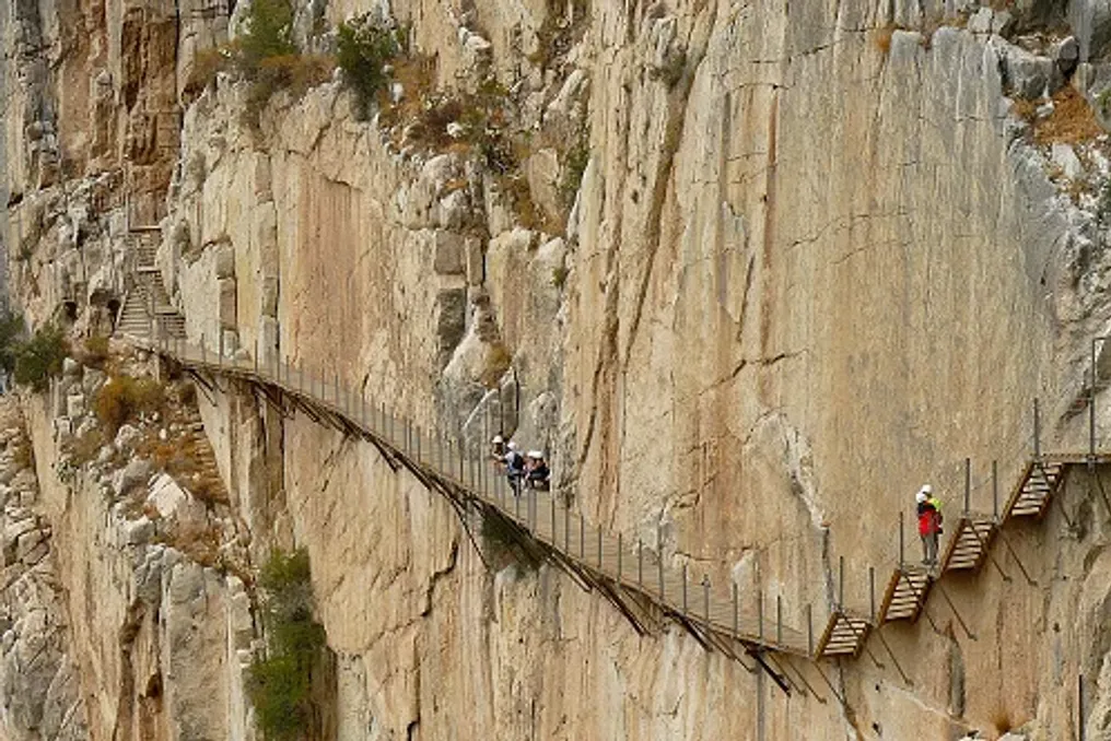
High above the river flowing through the limestone cliffs of southern Spain, a narrow pedestrian path clings to the walls of an impressive gorge. Wooden walkways extend along the sheer rock faces, and a suspension bridge crosses a dizzying drop into the valley below.

This is Camino del Rey, or the 'Little King's Path,' a remarkable route through one of Andalusia's most dramatic landscapes. Today, it is a popular destination for adventure tourists, attracting visitors with its extraordinary beauty and rich history.

Initially, this path was not intended for tourists. In the early 20th century, it was built to serve the region's hydroelectric industry. Over time, it fell into disrepair, gaining a reputation as one of the world's most dangerous routes, until a large-scale restoration transformed it into a managed pedestrian trail.

Located in the province of Malaga, Andalusia, Desfiladero de los Gaitanes is a magnificent natural passage carved by the Guadalhorce River. High limestone walls rise above the water, forming narrow passages, deep canyons, and expansive views of the surrounding mountains.

In some places, the gorge narrows to about 10 meters, and its dramatic rocks reach heights of hundreds of meters. The changing landscape gives Camino del Rey its unique character, taking pedestrians from open areas into sections where cliffs rise almost vertically on both sides.

Surrounded by a protected natural area, it is also home to diverse flora and fauna. Griffins, Egyptian vultures, and golden eagles can be seen above the cliffs, while the wider landscape supports wild boar and mountain goats.

However, the same harsh terrain that makes the gorge so imposing once presented a significant problem for engineers working on harnessing the river's energy.

The construction of Camino del Rey began in 1901 and was completed in 1905. Its original purpose was to connect hydroelectric power stations near Gaitanejo and El Chorro, allowing workers to transport materials, reach equipment, and service the infrastructure responsible for electricity generation.

The narrow service road was built directly along the gorge walls, providing access through terrain where building a regular road would have been difficult. Its exposed position made it a prime example of practical engineering, although its original function differed greatly from the adventure tourist attraction it became.

The route received its royal name in 1921 when King Alfonso XIII crossed the path during a visit to inaugurate the Conde de Guadalhorce dam. Since then, it has been widely known as Camino del Rey, meaning 'the Little King's Path.'

As the hydroelectric infrastructure developed, the original path became less important, and maintenance decreased. Natural elements led to concrete deterioration, protective barriers disappeared, and sections of the path collapsed.

Despite its condition, the path attracted thrill-seekers drawn by its exposed position over the gorge. However, growing notoriety came with danger, and fatal accidents in 1999 and 2000 prompted authorities to close access.

For many years, the damaged route remained a symbol of both engineering ingenuity and neglect, its broken sections hanging against the cliffs. Its future depended on finding a way to preserve the historic path while making the gorge accessible to visitors again.

Additional Information

Ultimately, a major restoration project transformed Camino del Rey into a managed tourist attraction. The restored route reopened in March 2015, with new wooden decking, safety railings, and modern safety measures installed along the gorge walls.

Instead of relying on the damaged original path, the new decking was built over sections of the old structure. Remains of the destroyed route remain visible beneath parts of the modern decking, reminding visitors of the path's industrial past.

The restoration preserved the dramatic landscape while introducing controlled access and safety requirements. Visitors follow a designated route and use safety helmets provided at the entrance. The result is an experience that retains the thrill of walking high above the gorge without exposing visitors to the dangers of the abandoned path.

The reopening also helped establish Camino del Rey as a main attraction in the province of Malaga, drawing new attention to the surrounding natural landscape.

The modern Camino del Rey follows a one-way route through the gorge, combining standard footpaths with elevated walkways attached directly to the limestone walls. The landscape changes along the way: from wooded valleys and open areas to narrow canyon passages where the river is far below.

The walkways are a defining feature of the route. As visitors move along the cliffs, the scale of the gorge becomes increasingly apparent. The rock formations reveal the geological history of the area, and the changing light emphasizes the textures of the limestone.

Wildlife adds another dimension to the experience. Griffins and other birds of prey may circle above the gorge, utilizing updrafts, while the surrounding protected landscape serves as a habitat for various species.

One of the highlights of the route is the suspension bridge near the southern end. Spanning approximately 110 meters across the dramatic drop of the gorge, it offers panoramic views of the surrounding cliffs and valley. For visitors comfortable at heights, the crossing provides a memorable finale to a walk combining natural beauty with human engineering.

Camino del Rey is located in the province of Malaga, between the Ardales region to the north and El Chorro, near Alora, to the south. The linear route covers approximately 7.7 km and usually takes three to four hours to complete, including approach and exit trails. Visitors should plan transportation as the route does not return to its starting point. A shuttle bus connects the northern and southern access points.

Tickets should be booked through the official Camino del Rey website, especially during peak tourist season. Visitors must arrive at least 30 minutes before the scheduled entry time and review official recommendations before leaving, as adverse weather conditions or safety issues may lead to closures.

Comfortable, sturdy hiking boots, drinking water, sun protection, and weather-appropriate clothing are necessary. Helmets are provided and must be worn as instructed. Entry is prohibited for children under eight, and the open walkways may be challenging for those suffering from severe migraines.

Although the restored route is managed for visitor safety, its elevated position and narrow passages require caution. Adhering to the marked route and staff instructions is crucial for responsibly enjoying the experience.

Camino del Rey is more than just a dramatic path overlooking a Spanish gorge. It is a story of industrial ambition, decline, and recovery unfolding in a landscape shaped by water over millions of years.

Built for hydroelectric needs, the original path eventually became notorious for its dangerous condition. Its restoration has given it a new purpose, allowing travelers to experience the Gaitanes gorge while maintaining a tangible connection to its engineering history.

For those exploring Andalusia beyond its historic cities and Mediterranean coast, Camino del Rey offers an unforgettable encounter with the rugged natural beauty of southern Spain, where a century-old industrial road has turned into an extraordinary adventure among the rocks.

Ciudad Perdida: Ancient Archaeological Site in the Colombian Jungle
Read more
getaway.co.za

Ciudad Perdida: Ancient Archaeological Site in the Colombian Jungle

Deep within the Sierra Nevada de Santa Marta tropical forest in Colombia stand ancient stone terraces amidst tall trees, rushing rivers, and misty mountains. This outstanding archaeological site, known as Ciudad Perdida or the Lost City, offers insight into the achievements of the Tayrona civilization and the indigenous heritage that continues to shape the region.

This multi-day trek passes through the tropical forest, crosses rivers, and follows steep mountain trails before reaching a network of stone platforms built centuries ago. However, Ciudad Perdida is more than just a remote archaeological find. Local communities call it Tayrona, and it is located on ancestral lands where cultural traditions, spiritual beliefs, and environmental stewardship are closely intertwined with the land.

Ciudad Perdida is situated on the northern slopes of the Sierra Nevada de Santa Marta, a mountain range that rises sharply from the Caribbean coast of Colombia. Archaeologists generally date the earliest settlement of the site to the seventh or eighth century, although its development continued for several centuries.

Architecture and Settlement Structure

Built by the ancestors of the region's indigenous people, Tayrona became an important center in a wider network of settlements connected by mountain trails. Its elevated position above the Buritaca River basin placed it in a landscape of exceptional ecological diversity, where tropical forests meet changing mountain climates.

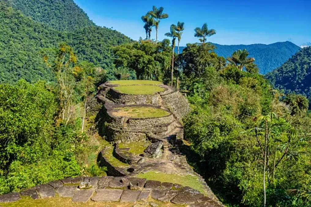
The settlement was not a city with monumental stone palaces. Instead, its architecture reflects a deep understanding of the terrain, including carefully designed terraces, stone staircases, retaining walls, and circular platforms adapted to the steep hillsides.

Over 200 archaeological structures have been identified at the site. The stone terraces supported round houses built from perishable materials such as wood and thatch, while paved paths connected different parts of the settlement.

The builders also developed systems for rainwater management and slope stabilization. Retaining walls supported the terraces, and stone pathways helped link residential areas, public spaces, and other structures on uneven terrain.

Rather than leveling the landscape, the builders worked in accordance with its natural contours. The result was a complex arrangement of platforms and paths that merge with the surrounding forest, demonstrating the engineering skills and ecological knowledge of the people who lived there.

Discovery and Scientific Study

Although local communities knew about the region and its history, Ciudad Perdida attracted widespread archaeological attention only in 1975 when remnants were discovered by individuals searching for pre-Columbian artifacts. This discovery followed a period of looting that damaged archaeological sites throughout the Sierra Nevada.

Subsequent archaeological expeditions documented the settlement, and the Institute of Anthropology and History of Colombia, known as ICANH, began a program of research, conservation, and restoration in 1976. This work helped establish Tayrona as one of Colombia's most important archaeological sites. Its terraces and paths provide valuable evidence of how communities organized settlements, managed steep topography, and maintained connections in the mountainous region.

Today, conservation remains a central element of site management. The stone structures are subject to heavy rainfall, vegetation growth, and human activity. Their protection requires careful visitor management and respect for the broader landscape.

Walking among the terraces offers a different experience compared to visiting archaeological sites dominated by monumental buildings. At Tayrona, the ruins are integrated into the forest, and the structures are interspersed with vegetation, uneven ground, and changes in elevation.

Circular foundations indicate where houses once stood, and larger platforms suggest areas used for public events and daily life. Stairs connect different levels, and paved paths show how people moved through the settlement.

Most information about the city's history comes from archaeological data rather than surviving written records. Therefore, the terraces are more than picturesque ruins; they offer clues about a society whose achievements were closely tied to the surrounding landscape.

Cultural Significance and Management

Ciudad Perdida is located on the ancestral territory of four indigenous peoples: the Kogi, also known as Kaggaba; the Arhuaco, or Iku; the Wiwa, and the Kankuamo. These communities maintain cultural, spiritual, and historical ties to the Sierra Nevada de Santa Marta. Their connection to the mountains extends beyond individual archaeological sites to encompass rivers, forests, peaks, and broader territories that sustain their traditions and way of life.

For these communities, the Sierra Nevada is not merely a scenic mountain range. It is part of a living cultural landscape where the health of the natural environment and the well-being of its inhabitants are closely interwoven. Consequently, Tayrona cannot be viewed simply as an abandoned city. Its importance continues through the living heritage of the indigenous peoples, who recognize the landscape as part of their ancestral world.

The Sierra Nevada is a place where environmental conservation and indigenous beliefs are closely linked. Traditional authorities continue to emphasize the importance of caring for the land and respecting sacred sites.

In October 2026, this interconnectedness was reflected in the temporary closure of the archaeological park. At the request of traditional indigenous authorities, ICANH announced that the site would be closed from October 1st to 15th to allow the land a period of rest and time for internal spiritual practices. The park subsequently reopened to visitors on October 16, 2026, with regular operating hours of 7:00 AM to 3:00 PM. This decision illustrates why access to Tayrona cannot be understood solely from a tourism schedule: the cultural and spiritual practices of the indigenous peoples are a vital consideration in site management.

Travelers can approach this experience with greater understanding by listening to authorized guides, adhering to local protocols, and recognizing that visiting an archaeological site does not mean the entire surrounding area is open for unrestricted exploration.

Journey to the Lost City

Reaching the Lost City requires significantly more effort than visiting a typical attraction. The journey usually begins in Santa Marta, a coastal town that serves as the main base for organizing treks into the Sierra Nevada. From Santa Marta, travelers travel by road to the rural settlement of Machete Pelao, also known as El Mamei, from where the route begins. The trail passes through forested hills, river valleys, and rural communities before reaching the archaeological park.

Most routes take four days round trip, although options ranging from three to six days may be available depending on the operator and itinerary. The hike involves humid conditions, steep ascents, muddy trails, and river crossings. Heavy rains can make certain sections particularly challenging.

Accommodation is typically provided in basic camps along the route, where tourists can rest, eat, and prepare for the next day. This experience differs greatly from a standard vacation, demanding physical exertion and readiness to move at the pace of the landscape.

One of the most memorable moments of the journey is approaching the archaeological settlement closer to the end, as tourists ascend approximately 1200 stone steps to the terraces. This climb serves as a fitting introduction to the city itself. After days spent navigating forest trails and crossing rivers, the stones lead to a network of meticulously formed platforms, winding paths, and green slopes.

It is best to explore the site slowly. Take time to observe the circular foundations, the layout of the terraces, and how the vegetation surrounds the archaeological remains. The setting helps visitors appreciate the practical difficulties faced by the builders and the scale of their achievements.

After touring the ruins, tourists return along the same general route to the start of the trail. Good preparation, appropriate footwear, and a realistic understanding of the terrain are necessary. The journey to Ciudad Perdida offers more than just the destination itself. The trail traverses tropical ecosystems shaped by variations in altitude, precipitation, and relief. Forest canopies, tangled roots, streams, and riverbanks create a constantly changing backdrop for the walk.

River crossings are part of the route, and conditions can change after heavy rain. Tourists must follow the instructions of their guides and avoid attempting crossings when water levels or currents make it unsafe. The birdlife, tropical vegetation, and sounds of running water complement the experience, although encounters with wildlife are never guaranteed. The forest is a living ecosystem, not a set piece created for visitors.

The route also passes through indigenous communities and territories, offering an opportunity to understand that the mountains are not desolate wilderness. Communities continue to live and work in the region, maintaining relationships with the land that predate modern tourism. Traveling with an authorized guide helps visitors navigate the route safely and provides context about the landscape and its cultural significance. Local guides, cooks, and other trekking staff also contribute to the visitors' experience, making responsible tourism an opportunity to support the people working in the region.

Visitors should ask permission before photographing people, homes, or culturally significant activities and respect any restrictions posted along the trail. The climate in the Sierra Nevada is humid and can be very rainy, so even a favorable forecast should not be considered a guarantee of dry conditions. Trails can become slippery, and the combination of heat, humidity, and steep terrain can make walking exhausting. Sufficient time must be allocated for the entire trek, provisions for rest must be made, and the route chosen must match your fitness level.

Tourists should book through authorized operators and check the latest access information before departure. The trail is not clearly marked throughout, and independent hiking is prohibited. A certified guide is required, so visitors must arrange their trek in advance and confirm what is included in the package. The announced reopening on October 16, 2026, is an important current update but should not be taken as a guarantee of uninterrupted access in the future. Temporary closures can occur for cultural and spiritual reasons, preservation, safety, or other operational reasons. Before leaving, check the latest announcements from ICANH and confirm arrangements with an authorized tour operator. The published park hours are from 7:00 AM to 3:00 PM, but multi-day trekking and accommodation must be arranged separately. Respecting closures and local instructions is part of responsible travel, not an inconvenience to be bypassed. The remote location of the site does not negate the responsibilities associated with visiting a protected cultural landscape. Stay on marked trails, avoid climbing on or moving stones, take all trash with you, and follow guidelines regarding photography and restricted areas. Tourists must also acknowledge that indigenous peoples have a voice in how their ancestral territory is cared for and used. Choosing an authorized operator, following the guide's instructions, and showing respect to local residents can help make this experience more respectful for all participants.
Popular