The Grand Ethiopian Renaissance Dam, known by the acronym GERD, is a colossal work of engineering and architecture that, despite connecting, also generates significant divisions. This mega-dam calls into question who holds the right to sovereignty over the river's water and energy resources, challenging the old Nile treaties established during the colonial era.
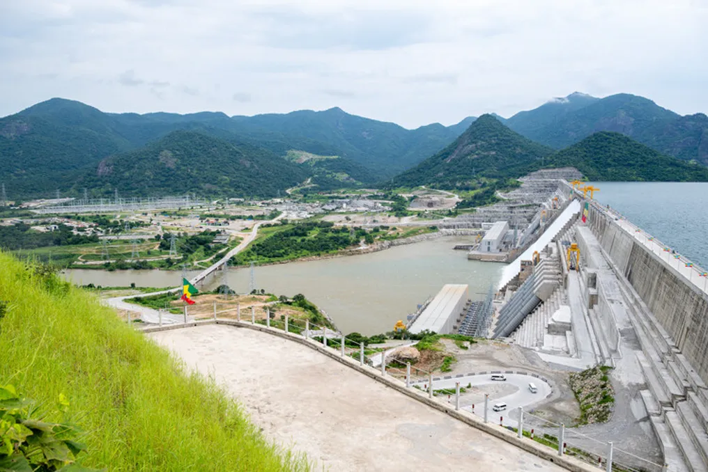
Inaugurated in September 2025, the GERD is a massive concrete structure located on the Blue Nile, in western Ethiopia, specifically in the Benishangul-Gumuz region. It is situated just 30 kilometers upstream and east of the border with Sudan. Its construction aims to make it one of the largest hydroelectric power sources on the planet, symbolizing Ethiopia's technological autonomy and economic advancement.
Dam Architecture Details
To understand the debate, it is essential to know its structure. The GERD was built under the administration of the civil engineering company Webuild (formerly Salini Impregilo) for the Ethiopian Electric Power. It consists of a main roller-compacted concrete (RCC) dam, an earth-fill arch dam with concrete lining, as well as spillway and hydroelectric power plant systems at the base.
With a designed capacity of 6,000 MW (although recent literature registers 5,150 MW), the dam is 1.8 kilometers long and reaches 175 meters in height. The main dam, only 14 kilometers from Sudan, contains a reservoir called Lake Nigat, with a capacity of 74 billion cubic meters of water, an surface area three times larger than Addis Ababa.
Additionally, there is a 5-kilometer-long and 50-meter-high earth-fill arch dam that serves for passive water containment in a lower area of the basin. The total average annual flow of the reservoir is about 50 billion cubic meters. Two hydroelectric power plants, equipped with 13 Francis turbines on both banks of the river, generate an average annual output of 15,700 GWh.
The spillway system ensures the dam's safety by allowing the safe discharge of floodwaters, keeping the reservoir level within planned limits. These include a main service spillway with gates, a freeboard spillway, and a side emergency spillway without gates, prepared for extreme events.
Internal Webuild laboratories were responsible for testing and developing materials to ensure structural stability and long-term mechanical performance. This was achieved through an advanced mix of RCC, developed internally and internationally, characterized by low cement and water content, and prolonged setting times. A network of galleries in the main dam houses high-sensitivity instruments, such as vertical pendulums, to monitor hydrostatic pressure, structural displacements, joint integrity, and turbine operation in real time. This data is sent to a centralized database at the right bank control center, enabling preventive maintenance and ensuring maximum structural reliability.
The reservoir's storage capacity allows GERD to modify seasonal flow patterns, manage floods, and produce energy. However, being part of an international and transboundary river system, the reservoir filling process raises questions about water needs and storage schedules. Filling cycles have been carried out unilaterally, without transparency between the upstream country and its downstream neighbors, intensifying geopolitical tensions.
GERD operation requires hydrological regulation, as lack of coordination and non-transparent data sharing can harm downstream infrastructure, such as the Roseires Dam in Sudan, due to its proximity to GERD.
Egypt alleges that Ethiopia's unilateral actions could reduce water flow, representing a national threat to its economy and population. The country also points to Ethiopia's 'unilateral exploitation' of transboundary waters in the Omo, Jubba, and Shebelle basins, in addition to the damage caused to its neighbors Somalia and Kenya.
Peaceful resolution of this issue could foster crucial regional cooperation on the White Nile. The disorganized release of water from Ugandan dams, for example, has already caused downstream flooding in South Sudan, resulting in forced displacement of people and disease outbreaks.
Historical Hegemony
In the initial planning of GERD, conducted in the 1960s, Ethiopia lacked internal stability to proceed with the project. The initiative was kept secret until a significant amount of work was completed, as it was known that its development would have a strong geopolitical impact, especially on nations located downstream in the basin.
This weight is amplified when considering that the Nile Basin countries total 11, distributed upstream, downstream, or in both positions. Nations strictly upstream include Burundi, Democratic Republic of Congo, Rwanda, Uganda, Tanzania, Kenya, Eritrea, and Ethiopia. Egypt is the only exclusively downstream country. Sudan and South Sudan occupy mixed positions: South Sudan is upstream relative to Sudan and Egypt, but downstream relative to Uganda, given that the White Nile receives rivers that flow into Lake Victoria.
The Blue Nile, which constitutes 85% of the total volume of the Nile River, originates in Lake Tana, in the Ethiopian Plateau, flows towards Sudan, and finally joins the White Nile in Khartoum to form the main course of the Nile, which passes through Egypt until discharging into the Mediterranean Sea.
Historically, water policy in the Nile Basin was dominated by Egypt's water hegemony, a legal pattern consolidated over a century of colonial-era 'treaties'—the Nile Treaties—in contrast to the search for a multilateral agreement that still conflicts with water use rights.
The Anglo-Ethiopian Treaty of 1902 initially secured Egypt's control over the Nile, prohibiting Ethiopia from altering the course of the Blue Nile without British permission. This supremacy was reinforced by the Anglo-Egyptian Treaty of 1929—which functioned more like an exchange of notes than a formal treaty, giving Egypt veto power over upstream projects or unilateral initiatives—and the subsequent Nile Water Agreement of 1959, which granted Egypt exclusive annual quotas of 55.5 billion cubic meters and Sudan 18.5 billion cubic meters.
However, the reality is more complex: although these unequal colonial-era treaties should be revised or revoked, Egypt remains a country with severe water scarcity, depending on the Nile for over 90% of its freshwater needs, with about 95% of the population living along its banks.
Furthermore, unlike other riparian nations in the basin—except Eritrea (which participates as an observer in the Nile Basin Initiative due to its low water impact) and Sudan (which suffers from infrastructure collapse)—Egypt depends on the Nile as a vital line of survival. Since GERD is on the Blue Nile, responsible for the majority of the river's total volume, the project implies a drastic shift in the regional balance of power, ending the 'monopoly' of water and generating apprehension for the agriculture and water security of downstream countries, especially during prolonged droughts.
To challenge this asymmetric control, the Nile Basin Initiative (NBI) was launched in 1999, followed by the Cooperative Framework Agreement (CFA) in 2010, just one year before the start of the Renaissance Dam works in 2011.
Due to the internal tensions of the Arab Spring, Egypt was unable to effectively oppose or block the project. Its isolation increased when Sudan softened its old objections, adopting a posture of moderate neutrality. Since then, the Sudanese position has frequently varied—between rejection, neutrality, or support—influenced mainly by its own internal political fragmentation. The debate over the pros and cons of the dam has also shaped these shifts in position. On one hand, the dam promises more stable irrigation, reduced dredging costs, and better flood management. On the other, it presents serious long-term risks: impoverishment of alluvial plains due to sediment accumulation in the reservoir, disturbances to local ecosystems, and the persistent lack of cooperation among the three nations.
Political pressure culminated in the Principles Declaration on GERD in 2015, which is the main trilateral milestone between Ethiopia, Sudan, and Egypt. In this document, the three countries recognized the existence of the dam and committed to the principles of international water law. However, to date, they have not reached a binding agreement on the rate of reservoir filling or on managing drought periods.
Disagreements persist on a broader scale. When the Nile Basin Cooperative Framework Agreement (CFA) came into force in October 2024, Egypt and Sudan refused to sign it, seeking to protect access to a vital resource and the veto rights they claim based on colonial treaties.
The Architecture of Geopolitics
Concrete structures can control physical flows of water, but they rarely solve political friction. Ethiopia presents GERD as a shared resource, built for its population and for neighboring countries, committing to exporting excess energy to boost its own economy and support the continent. However, hydrological uncertainty remains the biggest obstacle due to the absence of a clear and definitive agreement for the dam's operation.
A sustainable and equitable transboundary water governance model can be observed in the Senegal River Basin Organization (OMVS), which implements a model of collaborative benefit sharing and co-ownership of infrastructure.
In summary, unlocking the true potential of GERD as a driver of East African economic integration depends on overcoming impasses to ensure the security of downstream neighbors and establishing a new paradigm of equitable water governance, environmental security, and lasting trilateral cooperation. Otherwise, how can a shared river basin reconcile the right of one nation to build its economic future with the right of its neighbors to water security?