Development of Indian architecture around water: from coastal reclamation to data centers
Read more
ArchDaily Brasil
archdaily.com.br

Development of Indian architecture around water: from coastal reclamation to data centers

Historically, water was viewed by architecture as a mere backdrop, an obstacle to be drained, or a public service to be provided. However, in contemporary India, the relationship with water has taken on a dimension of great impact. Although water remains a shared ecological resource, the surrounding land and infrastructure are increasingly treated and financed as economic assets. This results in the expansion of coastlines to accommodate traffic and the transformation of lake shores into profitable real estate areas. This decision-making involves various institutions with distinct terminologies, complicating the definition of who controls the use of water and its surroundings, as well as who bears the consequences.

Mumbai was traditionally built through water diversion, and the Coastal Road follows this practice on an infrastructural scale. According to the Municipal Corporation (BMC), the 10.6-kilometer southern segment generated approximately 111 hectares of reclaimed land, designated for roads, bridges, roundabouts, and public spaces. The argument presented by the BMC focuses on improving mobility and public benefit, aiming to reduce travel time in the city and provide about 1.24 square meters per inhabitant in one of the planet's most dense metropolises.

In 2019, the Bombay High Court overturned coastal licenses due to the absence of appropriate scientific studies. Despite this, the court upheld the regulatory change authorizing reclamation for road construction, and the Supreme Court stayed the injunction, allowing the works to proceed. Issues regarding damage to coastal ecosystems caused by reclamation and the behavior of the retaining wall remain under debate without a definitive conclusion.

For local architect Alan Abraham, who later requested design modifications for the reclaimed section from the court, the core of the problem lies in priorities. He argued that 'the city needs roads, not the coast,' suggesting relocating the road inland so that public space could connect directly to the water. The BMC, conversely, responded that the project was based on expert studies and that alterations were no longer possible with most of the work completed.

The lakes of Bengaluru were initially planned as an interconnected system of artificial canals for rainwater drainage, known as rajakaluves. The preservation of these lakes depends less on regulations than on the demarcation of their boundaries. Municipal authorities established a uniform 30-meter buffer zone around the lakes, restricting construction in this area. However, in 2025, the state proposed an amendment that would replace these strips with buffer zones based on the size of the water body, offering no protection for smaller ones, and three meters for areas up to one acre.

Legal analyses indicate that the previous norms were deemed unscientific, and the bill would allow certain public utility structures, such as pumping stations and roads, within these buffer zones. This bill returned at the end of 2025 without consultation with the state expert committee or the public. Lakes that previously absorbed monsoon runoff and recharged the groundwater now direct this water into narrowed canals. Construction in these buffer strips can reduce space for water dispersion and infiltration during heavy rains, increasing surface runoff and pressuring already overloaded drainage networks.

A study on flood-affected neighborhoods confirms the significant presence of informal occupation or improper use of the canals connecting the lake network. In one locality, the water table dropped from about 100 feet to 600 feet in six years after a lake disappeared. In Bengaluru, the buffer zone ceased to be a natural element and became a legal figure, and its alteration redefines what can be considered buildable land.

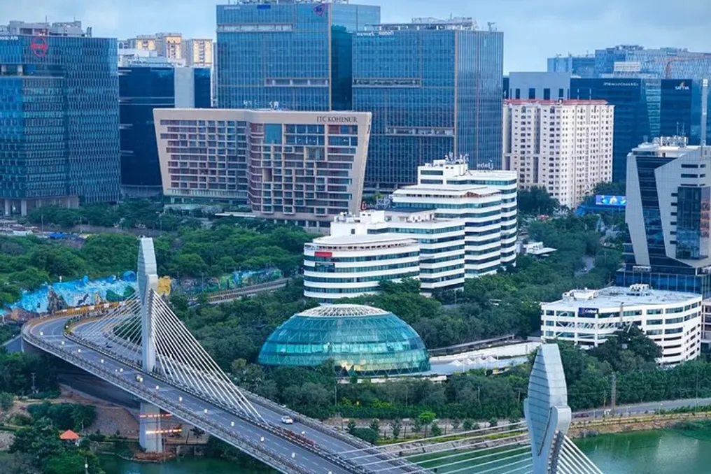
Data centers represent a problem of another magnitude, given that their water requirement is not visible in form or implementation of the building. WRI India reported that more than half of the country's data centers are located in water-stressed regions, concentrated mainly in five states: Maharashtra, Tamil Nadu, Karnataka, Telangana, and Uttar Pradesh. Furthermore, the proposed guidelines for 2026 in Uttar Pradesh foresee a continuous water supply for data centers, even if India currently lacks established requirements for disclosing water consumption data.

Decreased local water use can increase electricity demand, and since power plants also consume water, scarcity can be transferred to the energy grid instead of being resolved. In India, recycled urban wastewater is a supply resource needed by other users in water-scarce cities. In water-stressed Indian regions, the choice and design of a data center can impact water availability for residences, agriculture, and other local uses. A highly efficient facility in an overcrowded watershed still draws from a shared supply, making site selection essentially a decision about who gets access to water.

In summary, these three examples demonstrate water as a resource: displaced, limited, and destined for infrastructure. In all of them, as in most projects, the decision occurs before architectural planning. Architectural professionals often inherit existing conditions rather than shaping them.

However, architectural professionals can intervene individually in the early stages of the process. They have the capacity to question needs programs that assume guaranteed land, request water balances and hydrological assessments before accepting or proposing a location, and suggest alternatives to fixed layouts, as done by the Abraham collective. The Mumbai architectural community has adopted this approach on more than one occasion. The Mumbai Architects Collective, comprising about 120 firms, presented alternative design proposals for the Coastal Road. In Chennai, in 2019, design teams from the Water as Leverage program developed closed-loop water systems for neighborhoods.

Sustainability cannot be assessed solely by the performance of an isolated building, as this performance depends on the territory it occupies and the shared resources it utilizes. If water demand had been declared from the outset as a condition of the land, some of the buildings today considered inevitable might never have been proposed in their current locations. Whether the profession and the institutions that hire it are willing to start with this premise remains an open question.
Similar stories

Architecture and geological forms: how design is inspired by natural structures
Read more
archdaily.com.br

Architecture and geological forms: how design is inspired by natural structures

A canyon represents a space not conceived by humans; its walls reveal layers of rock accumulated over millions of years, and the passage between them was slowly sculpted by the action of water. Similarly, glaciers shaped valleys, leaving slopes as the ice retreated. Even before the emergence of architects, the Earth itself was producing these spaces.

For a long time, architecture professionals have sought geometric inspiration in the ground. A cliff can evoke a cut, a cavity can suggest a room, and stratified rock can inspire the arrangement of materials in layers. There are two main approaches: some build directly onto an existing formation, occupying a slope or cavity on site; others study the formation and replicate its characteristics in another location, either faithfully to the geological data or more conceptually, based on the general experience of the landscape.

These two methodologies impose distinct demands on architectural design. When a building integrates into a pre-existing formation, the terrain already resolves some structural challenges, as the cavity is already formed and the slope directs water runoff. However, when a formation is recreated elsewhere, only its geometry is transferred, requiring the architecture to ensure its structural stability and define its functionality through the program of use.

A direct example is the case of an established space. In Ca'n Terra, designed by Ensamble Studio in Menorca, Spain, an old marès sandstone quarry had a network of underground galleries that was later adapted for military use. The irregular dimensions and surfaces of these cavities, created by human excavation, defined much of the house even before the architectural project began. The Ensamble Studio team performed a three-dimensional scan of the galleries to determine the intervention points, which were specific. Skylights were installed to illuminate and ventilate the darkest areas, and new floor slabs were built following the irregularities of the terrain, using cement mixed with local stone powder. The focus of the architectural work was to make these cavities habitable.

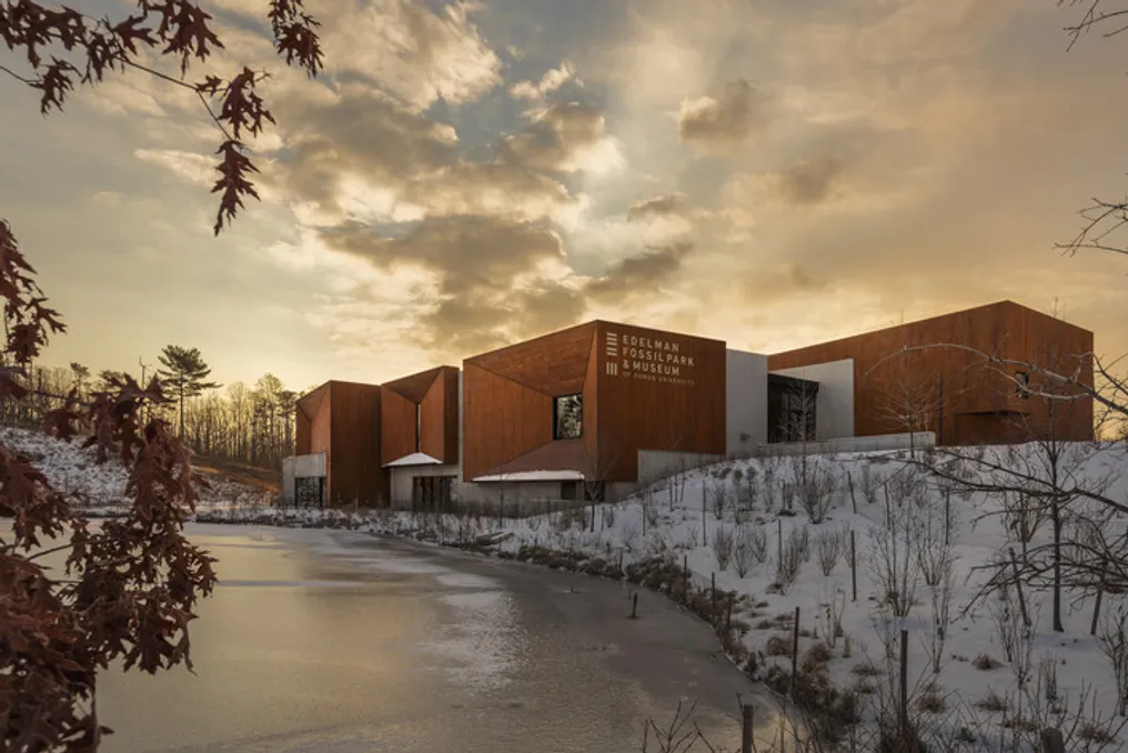
A slope can impose restrictions as firm as a cavity. At the Museum of the Earth, designed by the Weiss/Manfredi office in Ithaca, New York, the retreat of an ice layer resulted in a slope approximately 12 meters high, and the architectural team allowed this feature to dictate the organization of the building. Two partially submerged wings extend along the terrain, interconnected beneath the surface, and the museum's spatial layout follows the hill's cut. The incline also influences the visitor's path. A ramp descends following Barbara Page's installation, composed of 543 panels—each symbolizing a million years of geological history—making the descent through the building represent a journey through time. Externally, stone-clad terraces channel rainwater down the same slope toward a wetland basin. The existing slope served as the base for a new architectural cut, uniting the museum's circulation, public spaces, and water management.

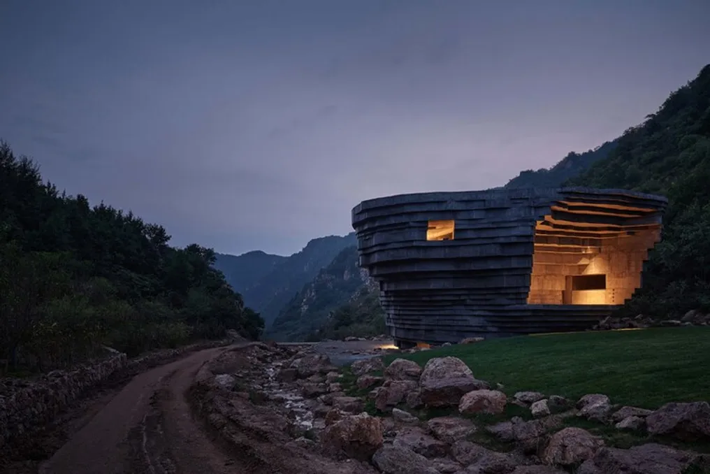
The dynamic changes when the geometry needs to be recreated. In one case, exposed strata show rock layers, and the Chapel of Sound, designed by OPEN Architecture—an open-air concert hall located in a mountainous valley near Beijing—adopts this stratification as its main form. The construction stacks successive layers of concrete, each projecting beyond the lower layer, resulting in a larger upper volume on a narrower base while maintaining a limited projection area. Just as rock strata support each other, these concrete layers advance outwards. The mountain's geometry has become a structural challenge that the mountain itself would never have faced.

Two concrete shells, an internal and an external, with the intermediate space acting as a truss, support these cantilevers. The acoustic aspect followed a similar path. The architectural team used natural caves as a reference to study reverberation and subsequently collaborated with engineers to calibrate the angles of the concrete surfaces, as well as the size and location of the openings. These openings regulate acoustics without the need for additional absorbent materials, allowing natural light and sounds from the valley to enter. Furthermore, the concrete incorporates aggregates of locally rich mineral rocks, establishing a direct material connection with neighboring formations.

When the formation is not visible, its geometry must be reconstructed from data. In Stavanger, Norway, the Geopark, designed by the Helen & Hard office, was conceived using survey data from the Troll oil and gas field, a reserve located thousands of meters deep beneath the seabed. The design team reconstructed fifteen geological layers at a 1:500 scale, then digitally isolated and modified parts of the model, thus generating the park's topography. Geometry preceded any assignment of use program.

Use came next. Based on this model, designers conducted workshops with local youth groups to define how the surfaces would be used. The area corresponding to the oil layer and drilling wells was transformed into a skate park, while the curved surfaces were designated for graffiti panels and exhibitions. The layer supporting Stavanger's oil industry thus became a public leisure space. Recycled materials from offshore installations link the park's construction to this same industry.

Reconstruction can also occur with a smaller volume of information. At One River North, by MAD Architects in Denver, Colorado, the canyons of the Rocky Mountains region serve as a reference for incorporating outdoor areas into a residential tower. A fissure equivalent to four stories runs through the glass facade between the sixth and ninth floors, housing landscaped terraces at different levels. Here, the architectural team creates the spatial experience of a canyon through a planned void.

Although the irregular walls, vegetation, and aquatic elements facilitate the recognition of the reference, the role of the fissure in the tower is deeper. A pedestrian path connects the terraces in a sequence of common spaces across several floors, providing residents with outdoor areas that, in a traditional residential tower, would typically be located on the roof or at the base. The canyon provides the image, but the residential program gives purpose to this geometry.

The difference between image and purpose modifies how we evaluate a geological reference in architecture. Mere similarity to the original formation says little about the design. What is crucial is how its characteristics are adapted to architectural needs: a truss formed between two concrete shells allows the cantilever of stratified surfaces, while the geometry of a reconstructed oil layer metamorphoses into a public leisure space. It is these choices that define the true value of the geological reference for the building, beyond its aesthetics.

Geological formations evolve on timescales far exceeding the existence of any structure, and the ground continues to change even after the completion of the work. Although a formation may lend its geometry to a building, what that geometry requires to be maintained and utilized must necessarily be provided by the architecture.

Modified wood: how technology enhances the properties and potential of the material
Read more
archdaily.com.br

Modified wood: how technology enhances the properties and potential of the material

Wood has been used in civil construction for millennia. Although it is a natural, renewable, and versatile material, its reaction to moisture requires meticulous attention in planning and specification. Fluctuations in humidity levels can cause expansion and contraction, and prolonged exposure to water promotes the development of fungi that cause rot. In the past, for outdoor uses, it was necessary to select inherently resistant species, apply physical protections, or develop design solutions that accommodated the natural behavior of wood. Wood modification emerges as an alternative, aiming to alter the intrinsic characteristics of the raw material.

What is modified wood?

Modified wood refers to natural wood that has undergone a specific process to alter certain properties of the material itself. The purpose is to enhance attributes such as durability and dimensional stability without compromising the aesthetic and sensory qualities that make wood such a valued material. Various technologies are commercially applied, such as thermal modification, furfurylation, and acetylation, each operating differently and generating varied performance profiles. This text focuses particularly on acetylation and its consequences for architectural projects.

Unlike traditional preservative treatments, which typically insert chemical compounds to shield wood against biological threats, modification works by altering the internal properties of the material. Depending on the chosen method, this can influence not only longevity but also how the wood interacts with moisture and environmental changes.

What is acetylated wood?

Acetylation is a modification process that occurs at the molecular level in wood. Acetyl groups naturally exist in its composition. During this procedure, hydroxyl groups—which have an affinity for moisture—are transformed into acetylated groups, which drastically reduces the wood's capacity to retain internal water. In practice, the resulting wood exhibits less dimensional variation (expands and contracts less), becoming more stable and showing greater resistance to fungal attack. Accoya is cited as a commercial example of acetylated wood, where fast-growing radiata pine is converted into an extremely durable and dimensionally stable material through this process.

Consider a deck exposed alternately to rain and strong sun, or a facade cladding subject to seasonal fluctuations in temperature and humidity. Doors and windows need to maintain precise fits even under constant exposure to the elements. In environments near pools or coastal areas, continuous exposure to moisture imposes even greater demands on the material.

When wood absorbs less bound water and exhibits less movement, its behavior becomes more predictable. Deck boards can maintain more uniform spacing; facade claddings remain aligned and firm. For doors and windows, reduced movement helps maintain the ideal fit between components, in addition to decreasing stress on finishes like varnishes and paints. Greater durability also allows wood to be used in applications that would be technically challenging with unmodified wood due to long climatic exposure.

Currently, Accoya wood is used in decks, facade cladding, doors and windows, landscaping structures, bridges, and other infrastructure works. Its performance is guaranteed by a 50-year warranty for above-ground installations and a 25-year warranty when in direct contact with soil or fresh water. Over the centuries, the choice of wood depended essentially on finding a species whose natural characteristics were suitable for the intended use. Wood modification adds a new dimension to this selection. Today, acetylated wood, with its improvements in dimensional stability and rot resistance, allows architects to expand the possibilities for using natural wood in high-performance outdoor areas.

Popular