Exploration of the Uhahalamba Gorges: Ascent of Sentinel Peak and Africa's Only Via Ferrata
Read more
Getaway
getaway.co.za

Exploration of the Uhahalamba Gorges: Ascent of Sentinel Peak and Africa's Only Via Ferrata

The Uhahalamba gorges resemble landscapes from the film 'The Land Before Time'; the vast plains depicted in Universal Studios dinosaur animation are visible from the 'Dragon's Tail' ridge on Sentinel Peak. The expedition's goal was to reach this view from Tugela Falls, the highest waterfall in Africa. Members of the expedition team, equipped with ropes and carabiners, prepared to ascend Sentinel and reach the waterfall by traversing the slopes.

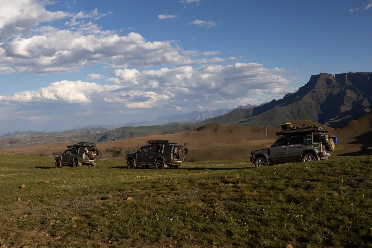
This trek marked the completion of the author's participation in the 44th geographical and humanitarian expedition 'Protector' led by Kingsley Holgate, titled 'Following the Dragon.' The expedition traced the entire Drakensberg range from Iron Crown in Limpopo to Rhodes in the Eastern Cape Highlands. Traveling in Defender 130 vehicles, the team connects remote valleys, high passes, and local communities along the escarpment, combining adventure with malaria prevention, spreading the spectacle Rite to Sight, supporting early childhood development, and providing environmental conservation education for schoolchildren. The foundation also notes the 25th anniversary of its partnership with Land Rover and Defender, which have helped Holgate's team make a difference since the beginning of the century.

For the first two days, the author spent time in a camp with the team in Golden Gate National Park, where eggs of Massospondylus, dating back 200 million years, were extracted from sandstone rocks above the camp, containing the oldest known dinosaur embryos. The park is also home to the Kgodumodumo Dinosaur Interpretation Centre, spanning 120 million kg, opened in June 2025, which consolidates the region's paleontological history in a center filled with full-scale models and interactive exhibits. The name is borrowed from a Basotho legend about a giant beast, fittingly near the Dragon itself. During these two days, park manager Paddy Gordon educated the group on the magic and history of the area.

From Golden Gate, the column ascended towards the border with Lesotho, where the ridge offered a perfect view of the peak they planned to conquer the next day, and of the vast amphitheater below. In the morning, guides advised waiting for the fog to clear but to bring a raincoat. When the sun broke through the 'Dragon's Breath' mist, they set off like hobbits on a seven-hour hike, feeling the pressure of altitude in their chests while trekking through the foothills in search of Sentinel, located at an altitude of 3165 meters above sea level.

There are three ways to reach the top of Tugela Falls: two nearly vertical ladders fixed to the rock, a steep ascent through the Bicorn Buttress gorge, or the 'Iron Path'—Africa's only Via Ferrata. Expedition member Mike Nixon explained that the existence of the 'Via' (Path) Ferrata (Iron) is linked to an unusual deal from World War I. In 1915, Italy was effectively bribed to join the Allies, receiving the promise of a significant portion of Austro-Hungarian territory according to a secret London treaty, and soon became involved in the mountain war on the front passing through the Dolomites. Moving troops and supplies across the vertical limestone using traditional methods was impossible, so both sides hammered iron steps, ladders, and fixed ropes into the rock, allowing ordinary soldiers to climb terrain previously intended for mountaineers. After the war, the equipment remained in place.

Unfortunately, the author learned a historical lesson when the group descended the gorge via a backup route. After experiencing the thrill of being connected to the mountain only by a rope and two carabiners while climbing the slopes at an altitude of about 3000 meters above sea level, overlooking the ravines below, adverse weather took over. The morning sun gave way to dense clouds and a stormy sky as lightning began to move rapidly across the landscape. After the first section of the Via Ferrata, there was no possibility of turning back. The guides decided to use the backup route for the group's safety. It was disappointing not to complete the route, but incredibly powerful to feel the energy of the elements and the immense heights during the first part of the ascent.

Although most of us feel that it is not over and we will try to return to climb Sentinel again, the trek was incredible nonetheless. The weather improved as they reached the bottom of the gorge, and while some returned to Witsishoek, several remained to blaze a new path to the Ladders to ascend the two steel strips attached to the side of the mountain. Some team members proceeded to Tugela Falls via the Ladders, and although they did not reach the summit, they accomplished the most important mission of the day: reaching Tugela Falls to fill the expedition calabash. Previously filled with a thin stream of water above a dinosaur footprint in the highlands of Golden Gate National Park, the calabash has traveled with every Holgate expedition since 1993, collecting symbolic water from the start of the journey and from iconic rivers and lakes along the route. The calabash will be emptied in a ceremony when the trip concludes in November.

On the first night in Golden Gate National Park, Paddy spoke about the spirit of the mountains, the intangible nature that permeates the sandy and clay slopes. Enveloped in the 'Dragon's Breath' and under the dominion of the elements, one truly understands the soul of these ancient escarpments.

Witsishoek

The Witsishoek mountain lodge, located beneath Sentinel Peak, serves as the gateway to the 'Dragon's Tail' Via Ferrata. Helmets, harness systems, and straps are available for rent at the lodge; day visitors are welcome, and a transfer by SUV to the Sentinel parking lot should be booked to conserve energy for the ascent.
Similar stories

Six South African reserves offer an alternative wildlife viewing experience
Read more
getaway.co.za

Six South African reserves offer an alternative wildlife viewing experience

The best wildlife interaction experience is not always achieved from inside a vehicle window. Within South Africa, nature reserves provide opportunities to explore the environment through organized hikes, following interpretive trails, studying local ecosystems, and gaining a more detailed understanding of wild areas.

The local forests of Garden Route are rich in exceptional flora and fauna diversity, much of which can be easily missed when traveling between destinations by car. Garden Route National Park offers several ways to experience these ecosystems on foot. In Garden of Eden, near Knysna, there is a short, wheelchair-accessible boardwalk featuring information boards detailing local fauna, Afromontane forests, forestry management, plants, and people. Visitors can explore the surroundings while birdwatching and observing other forest inhabitants. Further along the route, the Tsitsikamma section features interpretive displays and natural trails, including the popular Bloukrans Trail, which leads to a suspension bridge over the Storms River.

This UNESCO World Heritage site protects a landscape composed of sandstone formations, riverine forests, and savannas, while also preserving remnants of an important early African kingdom. The Mapungubwe Interpretation Centre provides information on the archaeology, cultural history, and biodiversity of the site. Visitors can also tour designated viewpoints and the park's canopy walkway, offering a different perspective on the surrounding landscape. The park's informational exhibits help connect the natural environment with the people who lived here centuries ago. This makes Mapungubwe particularly valuable for travelers interested in the intersection of nature conservation, archaeology, and human history. While wildlife viewing is possible, the main attractions are the educational facilities and the landscape itself.

Langebaan Lagoon is one of the main attractions in West Coast National Park, drawing birdwatchers and nature lovers year-round. Instead of relying solely on observations from a vehicle, visitors can spend time at bird hides and viewpoints, watching waterfowl without disturbing them. The park's interpretive signage adds another layer to the visit. Exhibits in the Geelberg and Syberg areas cover topics such as local birds, marine mammals, native plants, geology, archaeology, and coastal history. Postberg is particularly popular in spring due to its wildflowers, although access is seasonal. Walking through designated areas and stopping to read information boards helps visitors understand why the region's habitats are important for resident and migratory species.

Rietvlei Nature Reserve, located near Pretoria, offers opportunities to study nature through guided activities and birdwatching. The reserve has a dedicated walking trail designed for environmental understanding rather than just covering distance. This four-hour daytime hike requires advance booking and is conducted in groups led by a guide. It is intended for participants aged 12 and older. For those who prefer to observe wildlife from a stationary spot, the reserve is also equipped with six bird hides accessible along self-drive roads. These hides allow for birdwatching in their natural habitat and enable observations at a more relaxed pace. Before planning a trip, visitors should check current conditions and hiking requirements.

Approximately 10 km south of Gaborone, Mokoro Lodge offers diverse organized activities that bring visitors closer to Botswana's wildlife and landscapes. Depending on availability and the reserve's current program, activities include guided walks, rhino and giraffe tracking, horseback safaris, and game drives. The reserve also features an education center, museum, and library, making it a useful stop for travelers wishing to learn about nature conservation alongside wildlife viewing experiences. The Mokoro Lodge ecological education program welcomes school groups, helping young guests develop an understanding of biodiversity and the importance of protecting natural habitats. For travelers, the combination of organized activities and educational facilities provides several ways to engage with the reserve beyond traditional safaris. It is necessary to check which activities are running and if advance bookings are required before visiting.

Van Staden's Reserve offers a different approach to traditional wildlife excursions. Its seven walking trails allow visitors to experience the intersection of fynbos vegetation and forest, with plant diversity being a significant part of the interest. Visitors can arrange guided walks led by local guides who share information about the reserve's flora and fauna. Birdwatching and plant identification are also popular activities, and a wooden bird hide along Nymph Trail provides a spot for bird observation. The reserve is especially appealing to travelers who want to appreciate the fine details of the ecosystem, from local plants to the birds that depend on them. Organized walks last approximately one to two hours, and visitors should contact the reserve administration to confirm arrangements and payment.

Before visiting, check whether the walking routes are self-guided or require a registered guide. Some reserves only allow visitors to walk in designated areas, while others offer activities that must be booked in advance. Bring appropriate footwear, water, sun protection, and binoculars if you plan to birdwatch. Most importantly, remember that walking wildlife viewing requires respect for animals and their habitats. Follow the guide's instructions, stay on marked trails, and avoid approaching or feeding wild animals.

Cycling routes in the Eastern Cape, Karoo villages, and safari conclusion
Read more
getaway.co.za

Cycling routes in the Eastern Cape, Karoo villages, and safari conclusion

The road climbs into the mountains outside Graaff-Reinet, then moves into the open Karoo, where the next settlement may be far away, and the landscape seems to stretch endlessly. Here, the journey is as much about the places along the route as it is about the distance covered.

One such place is New Bethesda, a village with gravel streets beneath the Snouberg Mountains. Its most famous attraction is the Owl House, filled with hundreds of concrete sculptures created by Helen Martins, whose unusual house and garden later inspired Athol Fugard's play 'The Road to Mecca.' This curious sight in the otherwise quiet village of Karoo is a good reason to stop and linger longer.

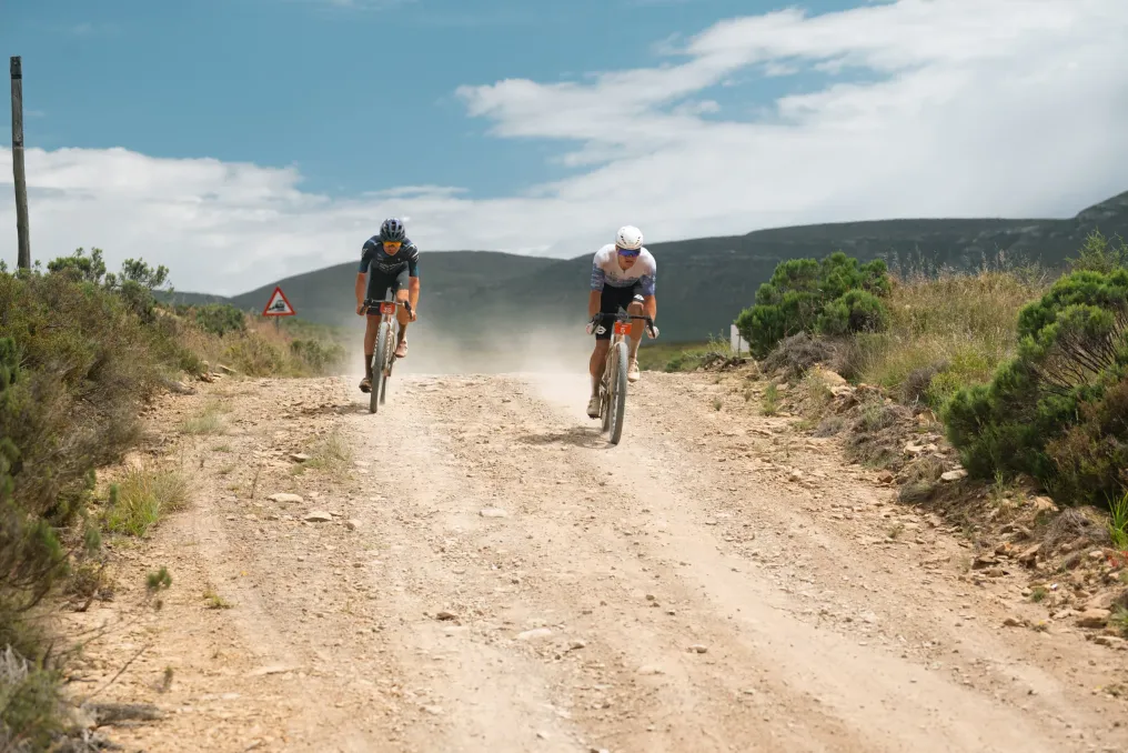
New Bethesda is also part of the Nedbank Gravel Burn race route, a seven-day gravel race held from October 25 to 31, 2026. The race covers 750 km and 8500 m of ascent, starting in Graaff-Reinet and finishing at the Shamwari private reserve, crossing remote Karoo areas before reaching the wildlife-rich bushveld of the Eastern Cape.

Supported by Nedbank, this event draws attention to the gravel roads and rural areas of the region. However, to appreciate the route, you don't have to be a cyclist. Historic towns, mountain passes, fossil-rich landscapes, and small settlements make this part of the country worth exploring at a slower pace.

Graaff-Reinet, recently renamed Robert Sobukwe town after the anti-apartheid leader born there, was founded in 1786. It is one of South Africa's oldest towns, featuring historic houses, museums, and an impressive Dutch Reformed Church in the center.

Take time to stroll through the old streets before heading out into the surrounding countryside. The city's architecture tells part of its history, but the landscape beyond it is equally memorable.

On the outskirts of the city lies the Kamdebo National Park, among whose best attractions is the Valley of Loneliness. Tall dolerite columns rise above the plains, offering wide views of the Karoo basin. The rock formations are particularly striking in the soft light of early morning or late afternoon, although the open viewpoints can be windy.

For cyclists, Graaff-Reinet is the starting point of the first stage of the Gravel Burn. The 90 km route leads to Cone Peak, followed by a challenging descent and a final open section to Blauwwater. Even if traveling by car, the landscape gives an idea of the distances and changing terrain that define this part of the Eastern Cape.

Where to stay: The Drostdie Hotel offers historic ambiance in the city center. Victorian Square Guest House is another option, while Rietjiesbos Self-Catering suits travelers who prefer their own space and kitchen facilities. Check current rates and availability directly with each property.

The second stage of the Gravel Burn is a 111 km loop route that passes through the Snouberg reserve, skirts Compassberg, and takes riders through New Bethesda. For independent travelers, the village is a worthwhile detour from Graaff-Reinet.

The main attraction is the Owl House. Helen Martins spent years transforming her home and garden into an extraordinary collection of sculptures, including owls, camels, and sky-gazing figures. Colored glass catches the light, giving parts of the garden an almost otherworldly appearance. The result is hard to mistake for anything else in the Karoo.

The Kitching Fossil Study Centre offers another reason to stay. The surrounding region is known for fossils of ancient reptiles and mammals that lived millions of years before the dinosaurs. It is a reminder that this seemingly harsh landscape holds a remarkable chronicle of life on Earth.

Take time to explore the village on foot, visit small galleries, and find a place to eat. New Bethesda is not a place to rush through between major destinations; its appeal partly lies in its quiet streets and the ability to spend a day without haste.

Some preparation is necessary. There is no petrol station or ATM in the village, so arrive with a full tank and cash. Most restaurants accept cards, but it is wise to check opening hours and book a table in advance. Road access can change, so check the local tourism website for the latest updates and closures before setting off.

Where to stay: Bethesda Guest House has rooms and a restaurant on site. Riad Maroc offers self-catering accommodation. The New Bethesda tourism website lists additional guest houses, cottages, and farm stays.

The middle stages of the Gravel Burn demonstrate how diverse the terrain can be. The third stage, 137 km, is the longest in the race. It includes the Wapadsberg pass, long flat stretches of asphalt, and coastal farms before the finish at Swartshoek Pass. The landscape changes as you ascend: dry Karoo gives way to greener highland meadow vegetation.

The following day is shorter, with a 61 km loop around the Klein-Visrivier valley. This is followed by a 128 km stage towards Gvanish, moving south and east through remote semi-desert landscapes on open gravel roads and rough farm tracks.

Throughout the race, you can catch a glimpse of the Indian Ocean before the route turns toward its final destination. By the time the riders leave the Karoo plains, the vegetation and relief begin to change, signaling the approach to the Eastern Cape bushveld.

This is not just about large distances on a map. The route is designed with the realities of gravel racing in mind: demanding surfaces, ascents, and open sections where the wind can complicate the ride. It also crosses private land, so the event route should not be considered a public cycling trail. Anyone planning to travel independently must use public roads, check accessibility and road conditions, and choose distances appropriate to their experience.

For visitors traveling by car, the same principle applies: there is no need to recreate the entire race. Choose a few destinations, allocate time for travel, and leave room for stops that catch your eye.

If you have an extra day, consider a detour to Kragga, also known as Nksuba. Founded as a frontier outpost in 1814, this town is located near the Great Fish River and has a distinctive historic center. Its 19th-century Dutch Reformed Church was modeled after St Martin-in-the-Fields Church in London.

Kragga is also associated with writer and social reformer Olive Schreiner, who lived in the area and is buried nearby. A short trip outside the town will take you to the Mountain Zebra National Park, where the mountainous landscape serves as a backdrop for wildlife viewing. The park was established to protect the endangered Cape Mountain Zebra, and visitors can also see other wildlife during a safari.

This is better viewed as an optional detour rather than a stop to fit into an already packed itinerary. Check travel times and park access before going and allow enough time to enjoy the area.

After the open Karoo plains, the landscape around the Shamwari Private Reserve feels like a completely different chapter of the journey. Grasslands, shrubs, and river valleys provide habitat for wildlife, including the 'Big Five.' The reserve is located deep in Gqeberha, near Paterson, and offers guided safari services for visitors staying in its lodges.

The sixth stage of the Gravel Burn covers 76 km, followed by a separate 33 km liaison section taking riders to Shamwari. The final stage is a 94 km loop through Founders Gate and Assagay, past Ali'sdale, and back to the reserve. It is a vibrant conclusion to a route that starts in the semi-desert and ends in the land of wildlife.

For travelers, Shamwari offers the chance to swap dusty roads for safaris and nights in the bush. Long Lee Manor boasts elegant heritage ambiance, while Sindile is a tented lodge overlooking the Bushman River and surrounding landscape. Bayethe offers another safari experience in tents.

Staying in a private wildlife reserve is a more significant part of the travel budget, so compare packages and confirm what is included. Meals, safaris, and other activities can vary depending on the lodge and booking. It is also worth checking the location of your chosen lodge within the reserve and the transfer conditions before confirming your stay.

Gqeberha (Port Elizabeth) is a convenient arrival point for this route. The drive to Graaff-Reinet takes approximately three to three and a half hours, and to Shamwari, about an hour from the airport. If traveling independently, arrange for a rental car or other transport suitable for your itinerary. Gravel Burn buses are only for registered participants and should not be assumed available to other visitors.

When to travel: The race takes place in late October, when days in the Karoo can be hot, and open sections offer little shade. Temperatures can drop after sunset, so pack layers of clothing and sun protection. Check the weather forecast before leaving, especially if you plan to cycle or spend time on remote roads.

Cycling tours and rentals: If you want to cycle part of the region, arrange your bike in advance and confirm availability, size, maintenance, and collection details directly with the rental provider. Ask accommodation owners about secure bicycle storage. Do not assume that bike rentals, transport support, or transfers will be available in small villages.

Driving and supplies: Refuel in larger towns before entering remote areas. Bring drinking water and essential supplies, download maps for offline use, and inform someone of your plans if driving on less busy roads. Mobile reception can be unstable in rural areas.

Accommodation: Book in advance, especially during school holidays and major events. The Blaauwater, Merino, and Gvanish Gravel Burn camps are part of the race organization, not standard accommodation options for independent travelers. Instead, book established guesthouses, hotels, or lodges in towns and reserves.

Three nights will not cover the entire Gravel Burn route, and this is no reason to try to cram everything in. A shorter trip is best if you choose a few spots and give yourself time to enjoy them.

If Kragga and the Mountain Zebra National Park are priorities, extend your trip or postpone them for another visit instead of trying to fit everything into three nights.

The Gravel Burn covers 750 km, but a great getaway in the Eastern Cape doesn't require a racer's number or a week in the saddle. Start with the old streets of Graaff-Reinet, take a detour to New Bethesda, and allow time for the places between the main stops. The reward is a journey through part of South Africa where the landscape changes dramatically, and where an unexpected village or quiet stretch of road can become the highlight.

Poisonous Plants of South Africa That May Look Harmless
Read more
getaway.co.za

Poisonous Plants of South Africa That May Look Harmless

South Africa is home to numerous plants that may appear completely harmless, blooming in the sunlight near walking trails, yet they contain chemical defenses strong enough to pose a danger to humans and animals.

These toxic species are found among grassy thickets, clinging to rocky slopes, and some grow in gardens where their attractive flowers are easily overlooked.

October is considered a suitable time to explore the darker side of the region's botanical diversity. While the veld awakens with new green growth and bright colors, beneath this beauty lie plants with a rather sinister reputation.

One such example is the poisonous euphorbia (Euphorbia virosa). This thorny succulent growth, found in the arid landscapes of South Africa, Namibia, and southern Angola, has thick, angular branches curving upwards from a partially buried stem. Although its sculptural form can look striking in a desert garden, its appearance is deceptive.

The plant exudes milky latex, which is extremely toxic and capable of causing severe irritation. Contact with the sap can damage the eyes and, in severe cases, lead to blindness. Historically, hunters from the San tribe used this latex as a component of arrow poison, although its irritating action made handling it dangerous.

Euphorbia serves as a reminder that even in areas with water scarcity and sparse vegetation, survival requires inherent defense mechanisms; its chemical protection performs this function autonomously.

Not all dangerous plants look menacing. The poisonous bulb (Boophone disticha), also known as the hyball or bushman's bulb, is widespread in many parts of South Africa and is characterized by a distinctive fan of grey-green leaves. Its unusual flower head can develop into a round structure that then dries and detaches, allowing the wind to disperse seeds.

However, underground lies a toxic bulb containing compounds that can cause serious poisoning if ingested. This species has a long history of use in traditional medicine. The popularity of this plant in herbal markets has also raised concerns about species conservation in certain areas of South Africa, as harvesting can put pressure on wild populations.

Here there is a worrying contrast: the plant may hold cultural significance and a long history of traditional use while posing real health risks. The poisonous bulb is an example of where botanical knowledge is important for both human safety and the survival of the species itself.

The name Acokanthera oppositifolia sounds like it should remain in a botany textbook, but its common name, bushman's poison, is far more ominous. This evergreen shrub or small tree is found in parts of South Africa and produces clusters of small, pale flowers followed by fleshy fruits.

The plant is highly toxic because toxic compounds are present in many of its parts. Historically, its sap was used by hunters from the San tribe in arrow poison preparations. The same chemical properties that made the plant useful in hunting create a serious risk of accidental exposure.

The history of this plant reveals another aspect of poisonous flora: toxicity is not merely a botanical curiosity. Over generations, people have accumulated detailed knowledge of local flora, including which species can heal, which can harm, and which require extreme caution. This knowledge deserves understanding within its cultural context, rather than being reduced to a collection of frightening plant names.

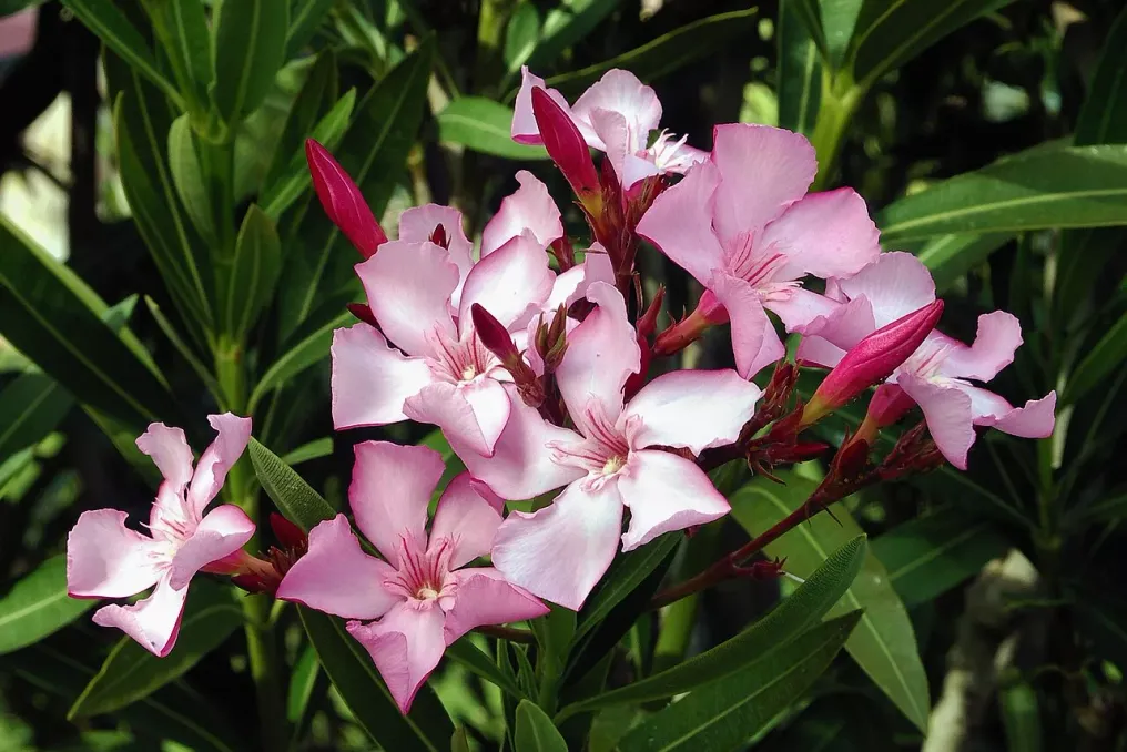
Some of the most dangerous plants are familiar garden residents. Oleander (Nerium oleander) is widely cultivated for its colorful flowers and ability to tolerate hot, dry climates. It looks quite cheerful next to a driveway or pool, yet every part of this plant is considered poisonous.

Oleander contains cardiac glycosides—compounds that disrupt normal heart function. Ingestion can cause serious illness in humans and animals, and its toxicity persists even after the plant material dries. Its popularity as an ornamental shrub serves as a reminder that poisonous plants do not always warn themselves with thorns, strange shapes, or alarming names.

The poisonous plants of South Africa are not villains in the conventional sense. Their toxic compounds evolved as part of survival strategies, helping them repel herbivores and defend against other threats. Some have influenced human history, while others remain vital elements of their natural ecosystems.

A sensible approach is to admire them without touching or tasting unknown plants. One should not assume that a colorful fruit is edible, that a familiar garden shrub is harmless, or that traditional use automatically makes a plant safe. If exposure or ingestion is suspected, immediate medical attention should be sought, rather than relying on online identification or home remedies.

The veld is full of wonders, but it does not always come with warning signs. Sometimes the most beautiful things growing near a path deserve the greatest respect.

Popular