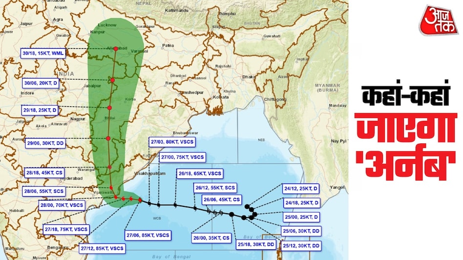
The powerful tropical cyclone Arnab has reached the coast of Andhra Pradesh. According to data from the India Meteorological Department (IMD), on the morning of October 28, 2026, the storm's center was located in the West Central Bay of Bengal, near the coast of Andhra Pradesh. Its center was situated 30 kilometers east of Narsapur, 45 kilometers southwest of Yanam, and 70 kilometers southwest of Kakinada.
Subsequently, the cyclone will move in a northwest direction, crossing the coast between Bapatla and Visakhapatnam. Wind speeds are expected to be 115–125 kilometers per hour, with gusts up to 140 kilometers per hour. After making landfall, Arnab will begin to weaken.
According to the IMD map, the storm will track from the northwest to the north. It will first pass through the coastal and inland areas of Andhra Pradesh, then move into Telangana and Chhattisgarh. After that, it will cross parts of Madhya Pradesh and head towards Uttar Pradesh, gradually weakening along the way. The storm is expected to transform from a powerful tropical cyclone into a strong tropical cyclone, then a tropical cyclone, a deep depression, and finally a depression or low-pressure area.
The storm's trajectory indicates that remnants of the cyclone may reach Uttar Pradesh. It could weaken in areas near Lucknow, Kanpur, Prayagraj, and Gorakhpur. Around October 30, it might turn into a designated low-pressure area with wind speeds of 27–30 km/h and dissipate in the eastern or central part of UP.
Furthermore, according to IMD data from October 27, 2026, the very strong cyclonic storm 'Arnab' was moving west-northwest at a speed of 18 km/h. At 09:00 UTC on the same day, it was in the same region, near latitude 16.2°N and longitude 83.3°E, approximately 140 km southeast of Kakinada. It is forecast to continue moving almost west-northwest for the next few hours, and then northwest, crossing the coasts of Andhra Pradesh and Yanam between Bapatla and Visakhapatnam as a very strong cyclonic storm with sustained winds of 125–135 km/h and gusts up to 150 km/h by 06:00 UTC on October 28, 2026. The system is under constant observation by Doppler weather radar in Visakhapatnam and Machilipatnam.
Due to this, a warning for heavy rainfall and strong winds has been issued for eastern Uttar Pradesh. Areas such as Gorakhpur, Dewaria, Basti, and Kushinagar are expected to be affected. Typically, cyclones weaken after making landfall due to friction with dry land air.
Arnab's northwest movement is attributed to seasonal winds and pressure systems. Many cyclones forming in the Bay of Bengal follow similar paths, moving across Central India northward. This leads to rainfall in parts of Andhra Pradesh, Telangana, Chhattisgarh, Madhya Pradesh, and Uttar Pradesh.
In the coastal areas where landfall occurred, strong winds and waves will persist. In inland areas, heavy rains may lead to rising river levels. Thunderstorms are possible in Uttar Pradesh from October 28 to 30. Farmers should take measures to protect their crops, and administrations must remain vigilant in low-lying areas. This forecast is based on IMD data and satellite imagery, and the situation may change, so it is recommended to monitor official updates. Arnab's journey will start on the coast of Andhra Pradesh and end on the plains of North India, where it will take the form of rain.