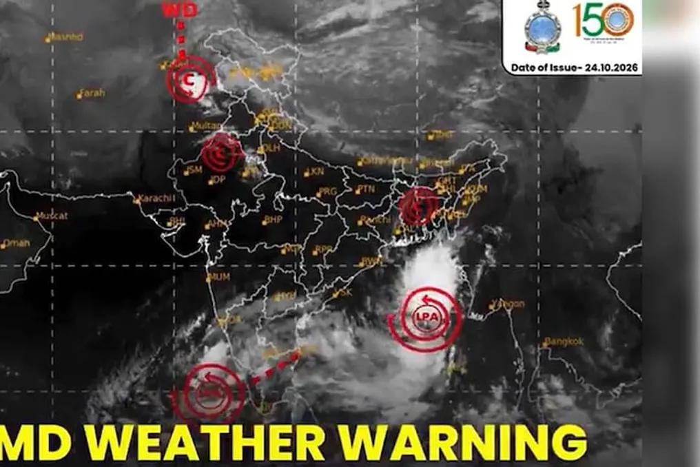
Meteorological Department warns of cyclone in the Bay of Bengal with threats on specific dates
Read more
Aaj Tak
www.aajtak.in

Meteorological Department warns of cyclone in the Bay of Bengal with threats on specific dates

The India Meteorological Department (IMD) has issued a warning that a low-pressure area formed in the east-central and southeast parts of the Bay of Bengal is rapidly intensifying. According to forecasts, it may become a depression by October 24, a deep depression by October 25, and transform into a tropical cyclone in the west-central part of the Bay of Bengal by the morning of October 26.

After this, the system will move in a northwest direction and is expected to reach the coast of Andhra Pradesh on the morning of October 28. There is a possibility of landfall between northern Andhra Pradesh and southern Odisha.

As a result of this system's impact, heavy rainfall is expected in various places in the coastal areas of Andhra Pradesh on October 27 and 28. There is also a risk of extremely heavy rains in Odisha and Telangana on October 28. Strong or very strong rain is forecasted for Odisha on October 27 and 29, with precipitation in some areas potentially exceeding 20 centimeters.

The coastal districts of Andhra Pradesh, such as Visakhapatnam, Srikakulam, and Vijayawada, may be most affected. Heavy rains and wind gusts may also affect the coastal areas of Odisha, including Ganjam, Gandham, and Puri. Flooding due to excess water is possible in some parts of Telangana. Sea waves may rise, and fishermen will be prohibited from going out to sea.

Heavy rains pose a threat of flooding in low-lying areas, road closures, power outages, and crop damage. Additionally, landslides are possible in hilly regions. Past experience shows that systems forming in late October often intensify rapidly due to persistent warm sea water.

State governments have taken precautionary measures in advance. Disaster management groups in Andhra Pradesh and Odisha have been placed on high alert, and rescue materials, boats, and medical teams have been prepared. Residents are strongly advised to follow official updates, avoid unnecessary travel, and remain in safe places. Fishermen have been advised not to venture into the sea.

IMD continues constant monitoring, as the intensity and trajectory of the system may change, making regular updates crucial. Due to climate change, storms can become more intense, so timely preparation is key. It is necessary to follow local authorities' instructions and avoid rumors on social media, obtaining information only from official sources such as the IMD website or app.

Similar stories

Meteorologists warn of rainy weather in South India in the coming days
Read more
www.aajtak.in

Meteorologists warn of rainy weather in South India in the coming days

The weather in South India is set to change soon: the northeast monsoon is expected to begin on the southern peninsula over the next two to three days. This was reported by the India Meteorological Department (IMD) on Monday.

The meteorological service specified that the withdrawal of the southwest monsoon continues in other parts of the country. With the onset of the northeast monsoon, there may be a prolonged period of rain on the Southern Peninsula over the next five to six days.

According to IMD data, heavy rainfall is expected in Kerala, Mahé, coastal and south-interior districts of Karnataka, Tamil Nadu, Puducherry, Karaikal, and coastal Andhra Pradesh from October 15 to 18 in various locations. Additionally, similar heavy rain is forecast for the northern interior districts of Karnataka on October 17 and 18, as well as in the Rayalaseema region on October 15 and 16.

India has two types of monsoons. The first is the southwest monsoon, which operates from June to September. It reaches the southwest coast of Kerala around June and then spreads across the country. This monsoon is crucial for India as it not only provides relief from the heat but is also vital for the country's ecology and agriculture, especially for rice crops.

The second type is the northeast monsoon, also known as the retreating monsoon. It occurs from October to December and affects the peninsular India. Although it is not as intense as the southwest monsoon, it is considered very important for the winter crop harvest.

This year, the southwest monsoon concluded with 759.4 mm of precipitation, which is 12.6% less than the normal amount of 868.6 mm. The reason for this decrease was the El Niño phenomenon, which formed in the equatorial Pacific Ocean in June and has been strengthening since then.

Global agencies, such as the World Meteorological Organization (WMO), predict that El Niño could reach its peak this year in December 2026, potentially becoming the strongest since records began in 1950. The El Niño condition is expected to persist until February 2027.

Popular