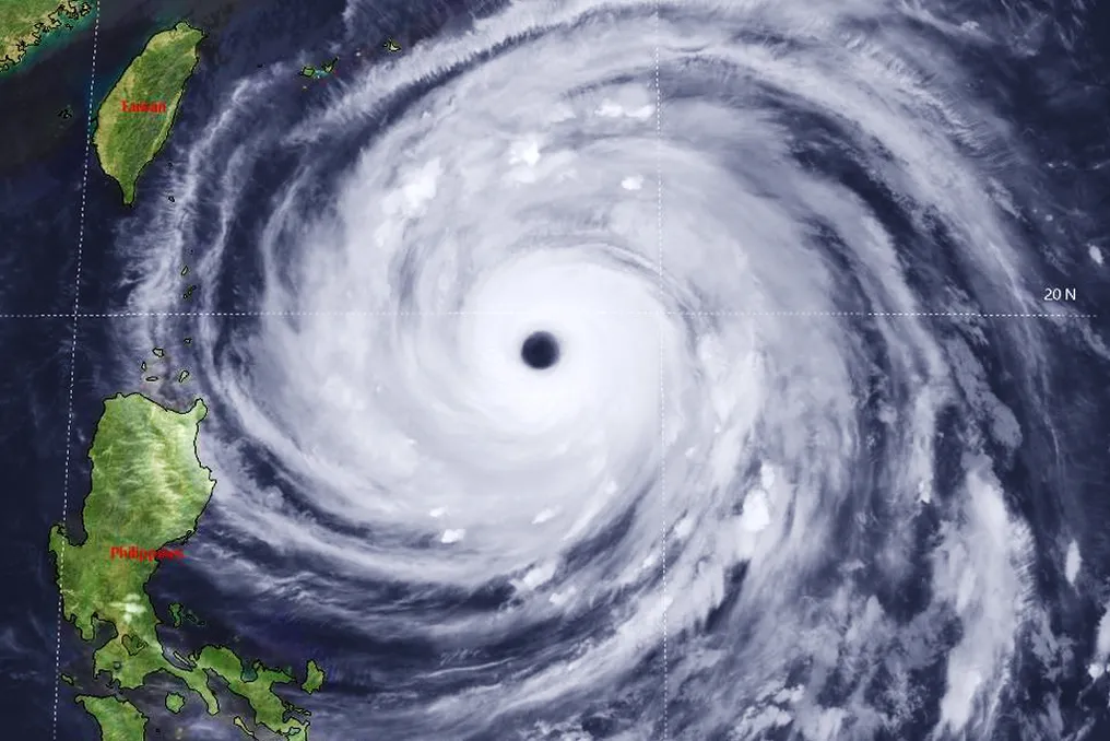
Super Typhoon Champi classified as the strongest storm of 2026 in the Pacific
Read more
Super Abril
super.abril.com.br

Super Typhoon Champi classified as the strongest storm of 2026 in the Pacific

Tropical cyclone Champi reached the status of the most powerful storm of 2026 on Wednesday morning, the 21st. With wind speeds close to 300 km/h and gusts forecast at 360 km/h, it continues its trajectory across the Pacific Ocean, posing a threat to Taiwan, China, and several locations in the Philippines.

According to the U.S. National Weather Service, the region is expected to be hit in the coming days by destructive winds, intense rainfall, and large waves. Currently, Champi has been classified as a Category 5 hurricane, the maximum level on the Saffir-Simpson scale used to measure hurricane intensity.

Tropical cyclones that develop in the Pacific are called 'typhoons.' Additionally, the prefix 'super' is applied by the Joint Typhoon Warning Center (JTWC) to storms whose winds exceed 240 km/h.

Current forecasts suggest that Champi should decrease its intensity soon, potentially weakening to Categories 3 or 4, although it still maintains destructive potential. There is a possibility that it will approach land even closer, towards Taiwan, between next Friday (23rd) and Saturday (24th), despite uncertainties about its exact route.

Champi is the fourth Category 5 cyclone in the Western Pacific season and the seventh globally in 2026. Researchers point out that the intense cyclonic activity may be related to El Niño, a phenomenon that alters atmospheric circulation and global oceanic conditions. While El Niño tends to reduce the number of tropical cyclones in the Atlantic, it causes a significant increase in occurrences in the Pacific.

Understanding the Super Typhoon

In essential terms, hurricanes, cyclones, and typhoons represent the same meteorological event; the nomenclature varies according to geographical location. Storms in the Atlantic and North Pacific are called 'hurricanes,' in the Southwest Indian Ocean they are 'tropical cyclones,' and in the Northwest Pacific, 'typhoons.' However, the underlying mechanism is identical.

The formation of these storms begins in the ocean, requiring the waters to be warm, ideally above 26.5°C. Several elements can contribute to this warming, including natural solar heating, events like El Niño, which redistributes oceanic heat, and global warming, driven by greenhouse gas emissions.

This mass of warm water plays two crucial roles: firstly, it serves as an energy source for the storm, providing more energy the higher the water temperature; secondly, it heats and humidifies the air above the sea surface. This triggers a process where hot air rises, generating a low-pressure zone around the affected area.

It is important to note that the hot air rises due to its expansion, making it less dense and consequently lighter than the surrounding air. This movement creates a 'vacuum' over the oceans, attracting winds from adjacent regions, characterizing the atmospheric low pressure. This combination results in prolonged and intense rainfall, along with strong winds that push water toward the coast, generating giant waves capable of flooding cities and villages.

At the core of these systems is the eye of the storm, a remarkably calm area. In the case of Champi, the atmospheric pressure reached 895 hPa, a value considered extremely low. This record is only surpassed by Hurricane Polo, which recorded 892 hPa at its center in the Eastern Pacific about a month ago.
Similar stories

Super Typhoon Champi moves towards the Philippines with winds up to 257 km/h
Read more
www.aajtak.in

Super Typhoon Champi moves towards the Philippines with winds up to 257 km/h

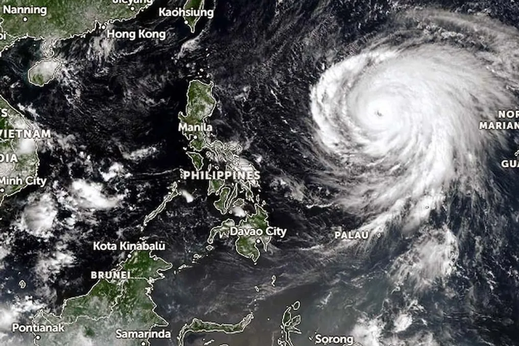
Super Typhoon Champi has intensified in the western Pacific Ocean, reaching significant strength. Its wind speed has reached 160 miles per hour, equivalent to approximately 257 kilometers per hour. Currently, the storm is moving through the Philippine Sea, between the Philippines and Guam. A clear 'eye' is observed at the center of the storm, surrounded by an extensive ring of thunderclouds.

Champi has reached Category Five, which is the highest category for typhoons. The storm is massive, and its clouds cover a large portion of the sea surface. As it remains over the open ocean, its trajectory and wind speed are being closely monitored. A change in the storm's direction could affect neighboring islands.

The wind speed of Super Typhoon Champi is 160 mph, or about 257 km/h. Such strong winds are capable of generating high waves in the sea. If such a storm hits a populated area, it could lead to fallen trees and damage to weak residential buildings and power line supports.

The Saffir-Simpson Hurricane Wind Scale is used to measure typhoon intensity, where Category Five is the highest. Typhoons in this category are characterized by sustained winds of 157 mph or higher. Champi's wind speed exceeds this threshold. However, the storm's category only indicates wind strength and does not provide a complete picture of potential damage from rain, flooding, and high waves.

On satellite images, Champi shows a clear central spot known as the storm's 'eye'. In severe sea storms, this area differs from the surrounding clouds. A wall of clouds forms around this eye, where strong winds and heavy precipitation can occur.

The appearance of a clear eye may indicate the storm's strength, but to determine its full power, wind speed, atmospheric pressure, and satellite monitoring data must be considered.

Champi is located in the Philippine Sea, between the Philippines and Guam. The storm's cloud bands extend over a significant part of the sea, making its affected zone very large. Nevertheless, the storm's large size alone does not mean it poses a threat to a specific area; this depends on its trajectory and distance from land. Heavy rains and high waves can also cause harm.

At Category Five, wind speeds are extremely high. According to the U.S. National Hurricane Center, such storms are accompanied by sustained winds of 157 mph or more. Such winds can uproot trees, disable power supply, and damage buildings.

For vessels at sea, such storms also pose a serious danger. High waves and strong winds make navigation difficult. It is crucial to monitor Champi's future direction. Current information regarding its strong winds, large size, and clear 'eye' does not allow for an exact prediction of which area the storm will head towards. Its direction and speed may change in the future, so the extent of impact on nearby islands will only become clear after receiving updated information from meteorological services. At present, Champi is an extremely powerful storm in the western Pacific Ocean.

Popular