Africa possesses numerous landscapes that drastically differ from the familiar safari stereotype. These landscapes reflect the continent's complex history, shaped by tectonic plate movements, ancient volcanic activity, sharp changes in altitude, and unpredictable water flow. Many of these natural wonders remain little known to the general public.
Eight such landscapes illustrate how much broader Africa is than just safaris. Among them are the surreal desert vistas of Namibia, the rugged highlands of Ethiopia, and the vanishing glaciers of Uganda.
Glaciers in the Rwenzori Mountains
Despite the equator being associated with tropical warmth, glaciers exist in the Rwenzori Mountains, located on the border between Uganda and the Democratic Republic of Congo. This mountain range, known as the Moon Mountains, reaches an altitude of 5109 meters at Margherita Peak, making it the third highest point in Africa. Its upper slopes contain glaciers, waterfalls, lakes, and unusual vegetation that is more suited to remote mountain wilderness than to the typical equatorial image of Africa.
The region's appeal lies in the change of vegetation zones: lower slopes give way to mountain forest, bamboo, and dense thickets, followed by heather moorland and high-altitude heath. Even higher, giant groundsel and lobelia create a stunning botanical landscape amidst the mist.
The Rwenzori Mountains National Park protects a significant part of this Ugandan massif and is recognized as a UNESCO World Heritage site. Due to its unique flora and diverse habitats, it is important for both nature conservation and trekking. For travelers prepared for challenging hikes, steep terrain, and rapidly changing weather, Rwenzori offers an experience far removed from traditional safari drives. The rewards here include mountain lakes, cloud forests, giant alpine plants, and the chance to see ice in the heart of equatorial Africa.
The Surrealism of Deadvlei and Sossusvlei
Few landscapes look as otherworldly as Deadvlei—a white clay plain surrounded by high orange dunes in the Namib-Naukluft region of Namibia. Against the backdrop of a bright blue sky are scattered blackened skeletons of camel-thorn trees, creating a scene that seems almost unreal. This landscape was formed by water before turning into today's arid environment. The Tsauchab River once reached this area, allowing camel-thorn trees to grow. However, when the dunes shifted and blocked the river's flow, water resources dried up, and the trees died.
The extremely dry conditions prevented the dead trees from decomposing normally; many have stood for centuries, their dark forms sharply contrasting with the pale clay and surrounding dunes. The result is a vivid testament to ecological change. Deadvlei is not just a collection of picturesque dead trees; it is an illustration of how water, sand, and climate can transform a landscape over time.
Nearby Sossusvlei is famous for its massive dunes, whose colors change depending on the light. Deadvlei offers a more minimalist picture, where the relationship between form, color, and space is the focus. Early morning and late afternoon are best for photographers when the light is softer and shadows are longer. Walking across the hot sandy terrain can be tiring, so visitors should bring enough water and prepare for intense sun.
The Geological Wonder of the Danakil Depression
In the Afar region of Ethiopia, the Danakil Depression looks less like a typical landscape and more like a view of a planet in the process of formation. Vast salt flats stretch to the horizon, volcanic terrain interrupts the plains, and in Dallol, mineral-rich hydrothermal formations create bright spots of yellow, orange, green, and white. These hues are due to minerals and chemical processes associated with the area's unusual geothermal environment.
It is one of the places where the forces shaping the Earth's surface become extraordinarily evident. The Afar region lies at the junction of major tectonic systems where the Earth's crust is spreading. Volcanism, geothermal activity, and the accumulation of salt deposits have contributed to the outstanding appearance of this territory. Dallol is particularly notable for its acidic hydrothermal pools and mineral formations. The bright colors may give the impression of painted earth, but these are not harmless natural swimming pools; the water chemistry can be extremely corrosive, and the landscape fragile.
The wider Danakil Depression area is also known for its extreme heat and harsh conditions. A trip there requires careful planning, reliable local expertise, and attention to current safety advice. The region's landscapes have been shaped by both geological activity and human history: salt mining has long been part of life in the Afar region, and traditionally salt caravans crossed parts of this difficult terrain. The attraction for visitors lies in observing an environment that challenges conventional ideas about what nature should look like. Nevertheless, Danakil is not just a spectacle of strange colors; it is a living landscape connected to local livelihoods and powerful geological processes.
The Nyungwe Forests in Rwanda
Moving away from Africa's usual dry plains and into the Nyungwe Forest, the landscape changes almost completely. In southwestern Rwanda, vast montane tropical forests cover hilly plateaus where mist settles among dense vegetation, and the forest cover transitions into peatlands, meadows, and wetlands. Nyungwe is one of Africa's important afro-montane forests, supporting a great diversity of plants and animals. Its protected habitats are home to endangered species, including eastern chimpanzees, as well as numerous birds and other forest fauna.
The character of the forest differs greatly from open savanna. Dense vegetation limits long-distance views, trails wind through damp undergrowth, and the sounds of birds and primates often betray the presence of wild animals before they become visible. Nyungwe also includes several habitats shaped by altitude and humidity. Its forested slopes and highland wetlands contribute to maintaining remarkable biodiversity, while the broader landscape plays an important role in the region's water systems.
One of the best ways to experience the forest is by walking across a canopy walkway. From here, visitors can observe the treetops and appreciate the scale of the forest, which would otherwise be difficult to see entirely. Hiking trails offer another way to explore, providing opportunities to learn about the forest's plants, birds, and primates with local guides. Nyungwe serves as a reminder that the African wildlife experience does not necessarily have to revolve around spotting large mammals from a vehicle. Sometimes the adventure lies in slowing down, walking through the forest, and discovering an ecosystem where every layer has its own life.
The Simien Mountains of Ethiopia
In northern Ethiopia, the Simien Mountains rise as a dramatic highland landscape with jagged peaks, deep valleys, and sheer cliffs. Millions of years of erosion have carved the plateau into a network of ridges and escarpments, some dropping approximately 1500 meters. The result is a scenery that resembles vast mountainous wilderness more than the flat open grasslands often associated with Africa.
The landscape is shaped by both geological history and altitude. The high plateau gives way to steep cliffs, offering expansive views of the rugged terrain and distant peaks. Changing light and passing clouds can lend the mountains an almost theatrical appearance, especially when mist rolls over the cliffs. This landscape is also home to unique highland wildlife: Gelada baboons gather in large groups on grassy slopes, and the endangered Walia ibex inhabits the rocky cliffs. The Ethiopian wolf, one of the rarest predators in the world, is associated with the highland meadows and heathlands of this region.
The Simien Mountains National Park protects this remarkable environment and is a UNESCO World Heritage site. Hiking trails allow visitors to experience the beauty of this place on foot, from viewpoints overlooking deep valleys to paths crossing open highland terrain. Conditions can be cooler than many visitors expect, especially at night and at high altitudes. Trekking requires preparation for altitude, variable weather, and uneven terrain. The Simien Mountains offer a different understanding of Africa's scale: the continent is not only a place of vast plains and deserts but also of highland plateaus, dramatic cliffs, and unparalleled mountain ecosystems.
Volcanic Activity of Erta Ale
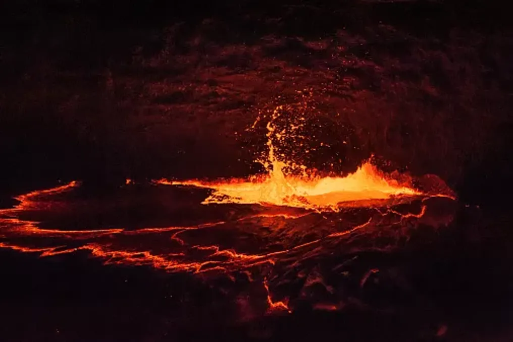
The Afar region of Ethiopia presents another geological spectacle in the form of Erta Ale—an active shield volcano known for its lava-filled crater and extensive fields of dark volcanic rock. The terrain is harsh and uneven. Basalt covers the ground, volcanic formations interrupt the horizon, and the crater serves as a reminder that the landscape remains geologically active. When a lava lake is present and visible, the molten rock can impart an unusual red glow against the dark surroundings.
Erta Ale is part of the wider Afar volcanic region, where tectonic forces are spreading the Earth's crust. The landscape reflects this ongoing activity, as volcanoes and lava fields provide insight into the processes gradually changing continents. Its fame as a site for viewing a lava lake has made it popular among adventure enthusiasts, but volcanic activity changes over time. One must never assume the presence of a glowing lava lake, and conditions must be checked before visiting. Reaching it can be difficult due to remoteness, intense heat, and rough terrain. Visitors should seek current recommendations from reputable local operators and follow all safety instructions, especially near the crater and active volcanic zones. Erta Ale presents a stark contrast to the green highlands in other parts of Ethiopia: instead of misty forests and fertile slopes, it is a landscape defined by rocks, heat, and restless forces beneath the Earth's surface. Together with Dallol, it shows why the Afar region is one of Africa's most unique geological areas, although each site reveals a different part of this history.
The Okavango Delta
The Okavango Delta presents a different kind of surprise. In northwestern Botswana, an extensive network of waterways, lagoons, reed beds, and seasonally flooded plains spreads out into the Kalahari sands. Unlike most large river systems, the Okavango does not flow into the sea; instead, its waters disperse across an inland delta, where they gradually evaporate or seep into the ground. One of the delta's outstanding features is the timing of its annual flood. Water coming from rainfall in the Angolan Highlands flows downstream and reaches Botswana during the dry season when most of the surroundings are desiccated. This results in a dramatic transformation of the landscape: channels fill up, and floodplains turn into wetlands.
The delta supports a huge diversity of habitats, including permanent swamps, seasonal grasslands, islands, and woodlands. These environments provide an exceptional number of wildlife, from elephants and hippos to waterfowl and small aquatic species. Although the Okavango is one of the most famous wildlife destinations in Africa, it deserves mention in this article because of its geography, not just its animals. Its defining characteristic is the contrast between the vast wetland and the arid landscape surrounding it. Visitors can explore parts of the delta on a mokoro, a traditional hand-carved canoe now often replaced by modern equivalents, by boat, on foot, and as part of organized wildlife tours. The experience depends on the location and water level.
On the northwestern coast of Namibia, the Namib Desert meets the Atlantic Ocean in a landscape of shifting dunes, wind-swept beaches, and constant coastal fog.