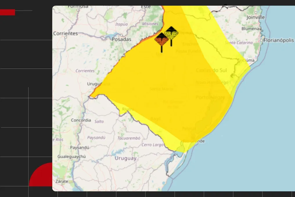
Voters in Rio Grande do Sul should be attentive to the weather conditions this weekend of the first round. After a period of intense rain, the state will face instability again starting Saturday (3), with forecasts of strong winds, storms, and the possibility of hail in several locations.
On Sunday (4), election day, rain is expected to persist during the early morning hours and at the beginning of the morning in certain parts of the state, although there is a projection of progressive improvement throughout the day.
According to Climatempo Meteorology, this new wave of precipitation is occurring because the soil remains very moist and many rivers still have high levels due to recent rains. This increases the risk of flooding, rapid increase of streams, and worsening floods.
Saturday will be a warning for storms
The forecast indicates that Saturday will be characterized by the return of storms across most of the state. Atmospheric conditions are favorable for the formation of unstable areas capable of generating heavy rain, hail, and wind gusts that may exceed 90 km/h in regions such as West, Campanha, Missões, Center, Northwest, North, Valleys, Serra, Costa Doce, and the Metropolitan Region of Porto Alegre.
In other areas, moderate to heavy rain is expected in isolated spots. Rainfall volumes should vary between 20 and 50 millimeters across most of the Gaucho territory, but some locations, notably Missões, Central State, Valleys, and Costa Doce, may record accumulations close to 90 millimeters.
In addition to rain, Saturday will start with low temperatures in several cities, with thermometers potentially indicating between 5°C and 13°C in the early hours. In the afternoon, the heat intensifies, and maximums can reach 30°C in some regions.
The National Institute of Meteorology (Inmet) issued two storm warnings for this Saturday: one of danger (orange) and another of potential danger (yellow).
Election Sunday still starts unstable
For those planning to vote early, it is advisable to monitor the weather conditions. The forecast indicates that Sunday will begin with rain and the risk of storms, especially during the early morning.
The North and Northeast regions of the state remain under threat of hail and wind gusts that may exceed 70 km/h. In the Metropolitan Region of Porto Alegre, Serra, and the Coast, rain showers are still expected in the early hours of the day.
However, with the advance of the cold front, there is a tendency for instabilities to decrease throughout Sunday. The improvement should be gradual and affect most of the state during the day.
The forecasted temperatures for Sunday range between 8°C and 18°C for minimums and between 16°C and 27°C for maximums across the entire state.