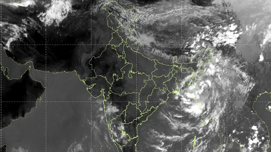
A depression that formed in the coastal area of Myanmar and near the Northeast Bay of Bengal will begin to weaken. According to data from the India Meteorological Department (IMD), over the last six hours, the system has moved in a north-northwest direction at a speed of about 13 kilometers per hour. Initially, this system was located near Mindat in Myanmar.
Previously, the system was located approximately 140 kilometers southeast of Chittagong in Bangladesh, 250 kilometers east-southeast of it, 310 kilometers southeast of Lengpui in Mizoram, and 370 kilometers south of Imphal in Manipur. IMD predicts that the system will continue to move in the same direction and gradually weaken.
Over the next twelve hours, this depression is expected to weaken and transform into a well-defined low-pressure area. After that, it will continue moving in a north-northwest direction. Over the subsequent twenty-four hours, the system may reach the southeastern part of Bangladesh and the vicinity of Myanmar, after which further intensity reduction is expected.
Even after weakening, the system may continue to move in the southeastern parts of Bangladesh and Myanmar. Its trajectory may also lead it towards Mizoram and Tripura, and its influence may persist in the Northeast Bay of Bengal region. Previously, on September 29, the system's speed was about 32 kilometers per hour during the day, and then slowed down to about 13 kilometers per hour by 23:30.
According to an official IMD statement dated September 29, 2026, the depression over coastal Myanmar and the adjacent Northeast Bay of Bengal and southeastern Bangladesh was moving in a north-northwest direction at a speed of 13 km/h over the last six hours. It was centered at 23:30 IST on September 29, 2026, in this region, near Mindat (Myanmar), approximately 140 km southeast of Hakhi (Myanmar), 250 km east-southeast of Chittagong (Bangladesh), 310 km southeast of Lengpui (Mizoram, India), and 370 km south of Imphal (Manipur, India). It is highly likely that over the next 12 hours, it will continue to move in a north-northwest direction and weaken into a well-defined low-pressure area over coastal Myanmar and the adjacent areas of southeastern Bangladesh and the Northeast Bay of Bengal.
After this, the system is likely to continue its movement in a north-northwest direction towards southeastern Bangladesh and adjacent areas of Myanmar, Mizoram, Tripura, and the Northeast Bay of Bengal, gradually weakening over the following 24 hours.
Due to this weather system, conditions in the Bay of Bengal may change. IMD warns of the possibility of rain and thunderstorms in some areas of the Andaman and Nicobar Islands, as well as possible precipitation in the coastal areas of West Bengal. The meteorological department is also monitoring sea conditions, noting that swell waves of 1.1 to 2 meters may rise in the Andaman Sea by the night of September 30.
According to IMD forecasts, there is no probability of further intensification of this depression; it will weaken while moving in a north-northwest direction. It is expected to transform into a low-pressure area within the next 12 hours, after which the system will head towards the regions of Myanmar, southeastern Bangladesh, Mizoram, and Tripura. The meteorological department is continuously tracking its direction and strength.