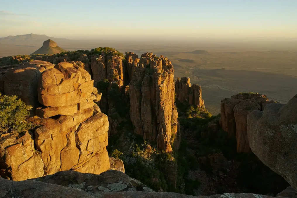
There are landscapes that make you stop and take a picture, and there are others whose views are so impressive that the camera is set aside. The Valley of Desolation, located near Graaff-Reinet, belongs to the latter category. This landscape is one of South Africa's most striking geological features, rising above the plains of the Great Karoo in the Eastern Cape.
Tall dolerite columns rise sharply from the cliff, while the vast Karoo stretches to the horizon below. This is a place where natural and cultural heritage meet, making it particularly suitable for Heritage Month. The landscape tells a story spanning hundreds of millions of years, while the surrounding area holds traces of people who lived here long before the modern town of Graaff-Reinet appeared.
The Valley of Desolation is part of the Kamdebo National Park, which almost entirely surrounds the historic town of Graaff-Reinet. The park's semi-arid landscape is characteristic of the Karoo and includes hardy shrubs, succulents, and grasses adapted to limited rainfall and sharp temperature fluctuations.
These dramatic rock formations arose from geological events that occurred during the Jurassic period. Molten magma penetrated layers of sedimentary rock and cooled underground, forming dolerite. Over millions of years, erosion removed the softer rocks around, leaving behind the more resistant dolerite. This process resulted in the collection of massive vertical columns visible today.
From a geological perspective, it is an example of how nature slowly creates its masterpieces. The formation of these structures took millions of years, and erosion continues to shape the landscape. SANParks estimates that the geological processes responsible for this landscape began approximately 200 million years ago, while current heritage information indicates that the dolerite intrusions formed between 180 and 100 million years ago.
The columns have given the Valley another memorable nickname—'Cathedral of Mountains.' Standing among them, it is easy to understand the reason for this name.
The Valley of Desolation is accessible by a road lined with viewpoints, as well as at the summit itself. From the parking lot, visitors can walk the Crag Lizard Trail—a route about 1.5 km long, taking approximately 45 minutes and passing by the Valley's viewpoints. Although this is a relatively short walk, the scenery gives the feeling of a real expedition.
The trail leads through rugged terrain to viewpoints overlooking the Karoo plains. From here, the grandeur of the landscape becomes evident: the dolerite cliffs dominate the foreground, while Graaff-Reinet and the surrounding plains appear surprisingly small in the distance. For hikers, photographers, and anyone who appreciates dramatic landscapes without needing to climb a whole day, this is a very worthwhile outing.
There is a good reason to stop often: the landscape changes depending on the lighting, with early morning and late evening emphasizing the texture of the rocks and the immense scale of the plains.
The heritage history of the Valley predates the roads and viewpoints that make it accessible today. Within the Kamdebo National Park, evidence of settlement from the early, middle, and late Stone Ages has been found, including stone tools such as axes, scrapers, blades, and grinding stones. Rock paintings in the park also testify to Late Stone Age hunter-gatherer communities.
People inhabited the area during the mid-1600s, while white farmers settled on the Kamdebo and Snouberg plateau starting around 1770. Agriculture subsequently became an important part of the region's history.
The landscape itself played a role in the history of nature conservation. In 1939, the Valley was declared a national monument of geological and scenic importance. Later, in the 1970s, conservation efforts intensified, as establishing a protected area in the Karoo became a national environmental priority. A special moment in this history involves students from different parts of South Africa. A charity campaign allowed children to purchase symbolic shares of the proposed reserve, and contributions from about 300,000 schoolchildren helped fund the creation of what became the Karoo Nature Reserve. The reserve was officially handed over in 1976 and subsequently incorporated into the Kamdebo National Park.
Kamdebo National Park was officially proclaimed in 2005. Today, it covers an area of about 19,405 hectares and protects the Valley, along with the wider Karoo vegetation, wildlife, and historical sites.
Thus, visiting the Valley of Desolation is more than just visiting another picturesque spot. It is an opportunity to see how geological history, human history, and conservation efforts intertwine in one landscape. The rocks record ancient changes of the Earth, archaeological finds point to people who lived here thousands of years ago, and the history of conservation demonstrates how South Africans ultimately united to protect this remarkable corner of the Karoo.
The road to the Valley has a history of its own. The original route was built using picks, shovels, wheelbarrows, and even dynamite, and was completed in 1930 at a cost of about 2000 Rand. Subsequently, the road was paved in 1978, significantly improving access to the stunning viewpoints.
Today, visitors can arrive by car, walk the trail, and ascend above the landscape created over millions of years. It is a huge amount of history for a morning walk. As part of Heritage Month, the Valley of Desolation serves as a compelling reminder that South Africa's heritage is not limited to museums, monuments, and historical buildings. Sometimes it is captured in rocks, painted on cave walls, and spread across the vast Karoo horizon. And this particular form of heritage is accompanied by a view that is hard to surpass.