48 Hours in Hualien, Taiwan: A City Where Mountains Meet the Pacific Ocean
Read more
Getaway
getaway.co.za

48 Hours in Hualien, Taiwan: A City Where Mountains Meet the Pacific Ocean

On Taiwan's east coast, Hualien is a place where the landscape speaks for itself. The Pacific Ocean stretches from the east, while the Central Mountain Range rises from the west. Nestled between these two features is a compact city rich in markets, culinary offerings, creative spaces, and a strong indigenous culture.

Hualien also serves as an entrance to the impressive Taroko area. However, it should be noted that this region is still recovering from the devastating earthquake in April 2024, so a visit in 2026 will differ from the classic routes described in old guidebooks. Some trails and attractions remain closed, while others are reopening as part of ongoing restoration work.

Spending 48 hours here allows you to combine relaxed urban leisure with views of the Pacific Ocean, indigenous flavors, mountain scenery, and the chance to see one of Taiwan's most dramatic regions.

The first morning is best started in the city center by visiting the Hualien Cultural and Creative Industry Park. This complex, formerly a winery, dates back to the Japanese colonial period. It has been transformed into a center for culture and creativity, where old industrial buildings are used for exhibitions, performances, shops, and cultural events. The original architecture is preserved, giving the complex a unique look compared to modern urban development.

This is an excellent introduction to Hualien, as it demonstrates that the city is not just a starting point for trips to the mountains; it also has a more leisurely, creative aspect to explore. Allocate a couple of hours to stroll among the old buildings, browse local goods, and have coffee before heading to the coast.

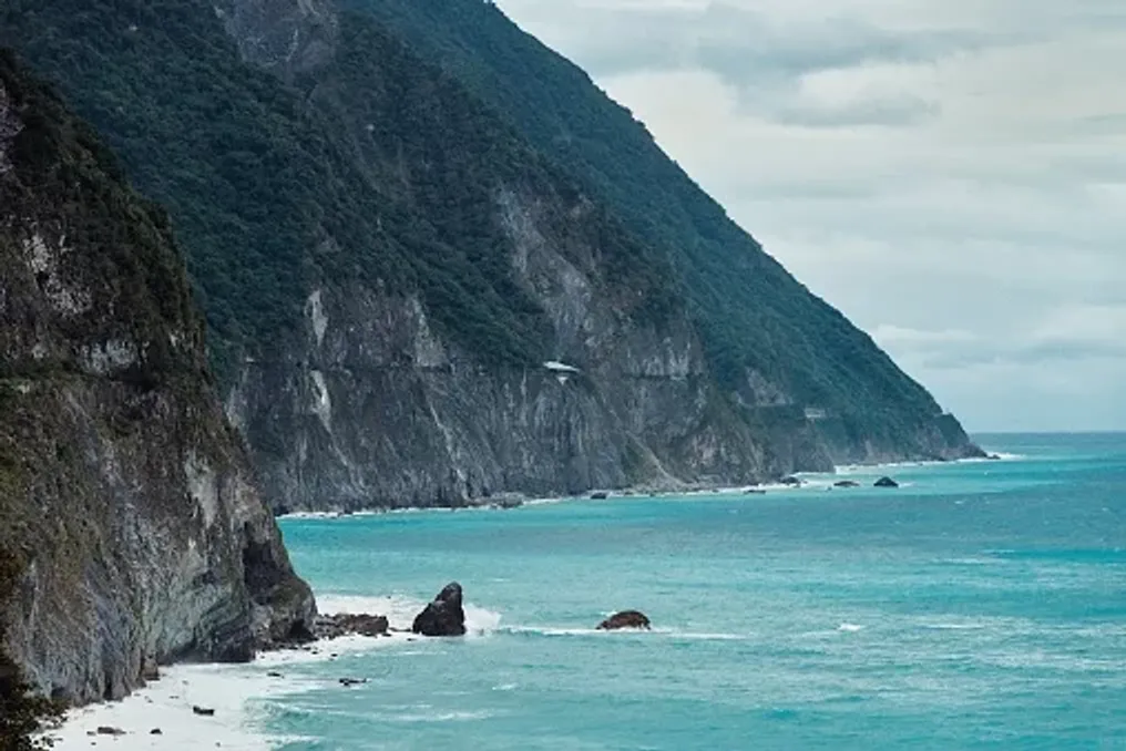
From the city, head north towards the scenic Qixingtan area. Despite its name, Qixingtan is not a traditional sandy beach. Its coastline is characterized by dark rocks, clear water, and expansive views of the mountains and the Qingshui cliffs. The combination of ocean and mountains is the quintessence of Hualien. It is worth taking time just to walk along the water rather than trying to cram too many activities in. The coastline is also part of a longer bicycle route connecting Hualien and Qixingtan, making cycling a convenient option for travelers who wish to explore at a slower pace.

Hualien is a good place to experiment with regional cuisine, rather than sticking to familiar Taiwanese dishes. You need to seek out restaurants and small eateries that offer local ingredients, seafood, and dishes influenced by the indigenous communities of Eastern Taiwan. The food culture of this region is particularly interesting because it reflects a blend of Taiwanese, Japanese, and indigenous influences.

Time must be set aside for the evening: the Hualien night market is where a true culinary adventure begins. As the sun sets, head to the Dundamen Night Market. With over 400 stalls, the market is divided into various sections, including Chinese cuisine, Indigenous Food Street, and the former Zixian Night Market section. Since 2015, it has become an important part of Hualien's evening gastronomic life. Instead of choosing one dinner, make the market your dinner. Try several small dishes and follow the aromas through different sections. Special attention should be paid to the indigenous food area, where vendors offer dishes using ingredients and flavors associated with Eastern Taiwan. One ingredient worth noting is makao—a local indigenous mountain pepper with a distinct citrus flavor. It appears everywhere, from hearty dishes to fried meat and snacks. You can also try rice rolls, mochi, and fried seafood, without forgetting to allow time for games and the lively atmosphere of the market.

After dinner, take a walk around the old railway zone, where the former rail corridor has been transformed into a pedestrian space dotted with shops and evening stalls. Staying in Hualien city allows you to start the early day for a trip to the mountains the next morning.

The second day is dedicated to understanding why Hualien is such a desirable destination. Taroko National Park is known for its magnificent marble canyons, steep mountain walls, and winding roads, but travelers coming in 2026 need to plan their trip differently. The earthquake in April 2024 caused extensive damage throughout the park. Restoration is ongoing, and roads, trails, and sites are opening in phases. Taroko National Park announced the reopening of routes within its ecological protection zone starting August 29, 2026, although other routes, including Qingshui Mountain and the old Zhuyulu road, remain inaccessible until further notice.

This means now is not the time to build an itinerary around visiting famous pre-earthquake spots. Instead, you should check the latest park announcements before traveling and choose from currently accessible areas. It is important to acknowledge changes in access rather than ignoring them. Taroko remains magnificent, but visitors are navigating a landscape that is still under repair. Heavy rains, typhoons, landslides, and rockfalls can affect accessibility, and the national park advises visitors to closely monitor the condition of the mountains.

For up-to-date information, it is recommended to visit the official Taroko National Park website before departing. If conditions permit, spend the morning exploring the officially open part of the park instead of trying to recreate the old pre-earthquake route. A useful starting point is the Taroko National Park Visitor Center. It provides context about the landscape and the park, helping to understand that the mountains are not just a dramatic backdrop for photos, but part of a living cultural landscape deeply connected to indigenous communities.

The indigenous culture of Hualien deserves more attention than just a fleeting mention alongside the scenery. The wider region is home to indigenous communities, including Truku, whose traditional territory covers the Taroko area. Their connection to the mountains, forests, and rivers is a vital part of understanding Eastern Taiwan. Time should be allocated on the second day to seek out indigenous food, handicrafts, or cultural experiences, rather than viewing the region solely as a hiking destination. Even the food encountered at the Dundamen night market serves as an introduction. Indigenous ingredients and flavors, such as makao, wild plants, millet, and local seafood, are found in dishes across the region. This is one detail that adds depth to a short trip to Hualien: you are not just moving between picturesque viewpoints, but experiencing a region shaped by its people as much as by its geography.

After the mountains, you can return to the coast. If time permits, return to Qixingtan for another walk or simply find a spot along the waterfront to watch the light change over the Pacific Ocean. This is a fitting conclusion to the trip, as Hualien's appeal lies in this dramatic proximity: in one day, you can move from a bustling city street to a mountain valley and back to the open horizon of the ocean. There is no need to fill the last hours with another attraction. Sit down, eat something local, and enjoy the view.

The charm of this itinerary is that it does not require rushing between sights. Hualien's location on the east coast makes weather a crucial factor. Conditions in the mountains can change rapidly, especially during heavy rains or after typhoons. This is particularly important for Taroko. Access to trails and roads can change quickly, so travelers must check official updates immediately before departure, rather than relying solely on information from old guidebooks. Taroko National Park specifically directs visitors to current traffic and road conditions for Highway 8 and other routes.

For a two-day visit, flexibility is more valuable than trying to rigidly plan every stop. Hualien is connected to Taiwan's railway network, making the city relatively easy to navigate without a car. Within the city, many main attractions can be reached by taxi, bus, bicycle, or on foot. Qixingtan is further away, and the Taroko region requires more planning, especially given current restrictions on roads and trails. If you rent a car or use a private driver for the mountain trip, check current highway restrictions and operating hours before leaving Hualien. The situation continues to evolve as post-earthquake recovery progresses.

It would be easy to view Hualien as merely a gateway to Taroko. However, spending 48 hours here reveals a different picture. It is a city where the Pacific Ocean is always close, where a former winery complex has turned into a creative space, where indigenous flavors mingle with Taiwanese street food, and where the mountains begin almost immediately beyond the urban sprawl. Taroko remains an important reason to visit, but Hualien itself deserves the time to slow down.
Similar stories

Great Kei Region Exploration: Rivers, Beaches, and the Khosa Culture in 72 Hours
Read more
getaway.co.za

Great Kei Region Exploration: Rivers, Beaches, and the Khosa Culture in 72 Hours

Great Kei is a quieter corner of the Eastern Cape where the river meets the sea, and small coastal settlements transition into green hills and rural landscapes. Over a period exceeding 72 hours, one can explore places such as Kei Mouth, Morgan's Bay, and Haga Haga, enjoying beaches, walks, local cuisine, and learning about the Khosa culture.

A journey through Great Kei should begin at Kei Mouth, where the Great Kei River flows into the Indian Ocean. This river originates where the Black Kei and White Kei rivers converge, northeast of Kathcart, and flows approximately 320 kilometers to its mouth at Kei Mouth. It has long shaped the landscapes and communities around it, remaining a popular spot for fishing, water sports, and bird watching.

One of the most memorable spots is the historic Kei Mouth ferry. This vehicle ferry connects to Great Kei and leads into the wild coast. It is also one of Kei Mouth's main attractions and a reminder of the close connection between travel in this part of the Eastern Cape and the river. Time should be set aside to watch the ferry pass before moving along the coast.

The mouth of the Great Kei is a natural place conducive to slowing down. Depending on conditions, one can spend a day fishing, birdwatching, kayaking, or exploring the river by boat. The estuary and surrounding vegetation support diverse avifauna, and the river itself remains an important part of the area's recreational life.

If the preference is for the land, one can take a walk through Kei Mouth and along the coast. The area also provides access to trails leading into Morgan's Bay. Relaxed and local dinners are recommended; Great Kei is not meant for rushing between restaurants and attractions. Its appeal lies in long meals, seafood, rustic food, and evenings outdoors. One can stay overnight in Kei Mouth or slightly further, in Morgan's Bay.

Traveling along the coast between Morgan's Bay and Haga Haga involves a change in the Great Kei landscape: from riverine areas to beaches, cliffs, rocky shores, and small coastal villages. The start of this section is Morgan's Bay, also known as Gxarha, where a long beach is situated beneath dramatic coastal cliffs. The beach is popular for walks, and trails lead along the cliffs to the Cape Morgan lighthouse. The cliffs themselves rise approximately 50 meters above the waves, making this a prime spot for coastal views.

For a longer walk, the routes continue towards Dobbel Mouth reserve and further to Haga Haga. The distance from Morgan's Bay to Dobbel Mouth is about 4 km, and the path to Haga Haga adds another 8–9 km, so planning must account for physical fitness and weather. The Cape Morgan lighthouse is also a worthwhile stop. From Morgan's Bay beach, the trail leads to the lighthouse through coastal and wooded terrain, then continues towards Kei Mouth. This is a good example of what makes this stretch of the Eastern Cape special: no tight schedule is required, as the landscape itself provides most of the entertainment.

Next is Haga Haga, a small coastal village known for its beach, stone coves, and relaxed atmosphere. The municipality describes Haga Haga as a family-friendly coastal destination with safe swimming beaches and ocean views. It is an ideal place to do little: stroll on the beach, explore stones at low tide, have lunch, and watch the waves. For travelers with children, it is a simple place to spend several hours due to the shallow stone coves and calm rhythm.

The second night can be spent in the Haga Haga or Morgan's Bay area. There are numerous accommodation options in the wider area: from hotels and lodges to self-catering units and campsites. The Great Kei municipality lists tourist offerings such as Morgan Bay Tourism, Crawfords Beach Lodge, Olivewood Private Estate, and Yellowwood Caravan Park.

On the final day, it is recommended to leave the coast and venture inland. Great Kei is more than just its beaches. Inland, the landscape becomes more rural, featuring farms, villages, and open land stretching towards Kumre (Komge). The municipality extends from the Indian Ocean to the Kubusi River, with the landscape becoming drier as one moves inland. Kumre, better known as Komga, is a service and business hub for the surrounding agricultural areas and offers a different perspective of Great Kei than the coastal villages.

Instead of viewing the town as a quick stop, the trip inland should be used to appreciate the changing scenery. Roads pass through farmlands and rural settlements where the pace of life noticeably differs from more well-known coastal destinations. The rural areas around Great Kei also play an important role in the region's cultural identity. The municipality emphasizes traditional storytelling, cultural tours, historical sites, and everyday rural life as ways visitors can experience the Khosa heritage in the area.

Where possible, one should choose experiences organized by locals rather than simply passing through. A guide, a community experience, or a meal prepared by local hosts can add context to the landscapes you traverse. Food is an especially good way to immerse oneself in history. Opportunities to try traditional dishes and local delicacies should be sought, allowing hosts to explain the ingredients and traditions behind them.

In the afternoon, one can return to the coast, leaving enough time to stop at viewpoints and small villages along the way. If there is another night, one can return to Morgan's Bay or Kei Mouth and conclude the trip by the water. If further travel is planned, the main connection to the broader Eastern Cape road network is provided by the N2 road.

Great Kei is not dependent on a single main attraction. Its appeal lies in the combination of various landscapes: the river and its estuary, the old ferry in Kei Mouth, the cliffs and beaches of Morgan's Bay, the quiet shores of Haga Haga, and the inland rural communities. Together, they create a place that feels distinctly like the Eastern Cape, without requiring a packed itinerary. It also serves as a reminder that the Eastern Cape coast extends far beyond the more famous Wild Coast destinations. In Great Kei, one can experience beaches, rivers, hiking, food, and Khosa heritage within a relatively compact area. The best way to get to know this region is to move slowly: follow the river, stop when a view catches your eye, eat local food, and leave room in the plan for unplanned stops.

Always check local conditions before entering the water. The Great Kei municipality temporarily closed Kei Mouth beach in January 2026 after the discovery of a dead whale shark and reports of sharks at several municipal beaches. Conditions and closures can change, so current local notifications should be checked before swimming, surfing, or fishing.

A Journey Through the Heart of the Great Karoo in South Africa: 48 Hours Among History and Nature
Read more
getaway.co.za

A Journey Through the Heart of the Great Karoo in South Africa: 48 Hours Among History and Nature

The Great Karoo is a place conducive to slowing down the pace of life. Its open plains, rocky hills, and small settlements create an atmosphere far removed from daily hustle. Over a period exceeding 48 hours, one can travel through Victoria West, Beaufort West, Fraserburg, and Loxton, enjoying local cuisine, historical buildings, fossils, and quiet country roads. Along the way, you can discover stories spanning millions of years, old theaters, sheep farms, and endless skies.

From the N1 route, the Karoo might appear as a long stretch of dry scrubland with distant mountains. However, by choosing a slower route, many more attractions are revealed. This trip is for those who enjoy taking their time, stopping to eat at a farm, exploring a small town museum, or simply pausing to admire the landscape. At night, the clear skies of the Karoo offer another reason to take it easy.

Victoria West is a suitable starting point. Founded in 1843, this small town is situated between the Upper Karoo ranges and is full of reminders of its 19th-century past. Its location at the intersection of roads N12, N10, and R63 makes it a convenient base for exploring the surroundings. It is worth starting a walk in the old part of the town, where Victorian-era buildings are located on Church Street. The Victoria West Museum deserves attention for its collection of local history, archaeology, and fossils, including ancient fish fossils from the distant past of the Karoo.

Further on, you can find one of the city's most unusual landmarks—the Apollo Theatre. This Art Deco cinema dates back to 1928 and is recognized as a heritage site. Victoria West is not a place to build a route around a long list of restaurants; instead, you should look for local cafes or eateries and make lunch part of the experience. Since the Karoo is a sheep-farming region, it is better to seek out regional dishes and produce here rather than expecting a typical urban gastronomic scene. The focus is on lamb, homemade bread, preserves, and simple farm food.

Leaving Victoria West towards Beaufort West gradually reveals the classic landscapes of the Karoo. Sheep farms stretch toward low hills, plains are adorned with windmills, and the vast sky becomes increasingly noticeable. The landscape itself is one of the main attractions, so do not view this section merely as transit between towns. If possible, stop safely, photograph the changing light, and watch for birds and wildlife.

The greatest story of Beaufort West began long before the city existed. The surrounding Karoo holds international significance due to its fossils. The first reptilian fossil near Beaufort was found in 1827, after which the area became one of the world's richest sites for fossil collection. Visiting the Karoo National Park allows travelers to connect the passing landscape with this outstanding geological history. The park features a Fossil Trail that explains the local paleontology and geology. This short trail is particularly useful as it makes the abstract history of fossils in the Karoo tangible: visitors can see evidence of ancient creatures and environments preserved in the rocks.

Upon returning to the town, spend time exploring Beaufort West on foot. The historic center is an eclectic mix of Victorian, Georgian, Edwardian, Cape Dutch, Neo-Gothic, and other architectural styles. The Old Town Hall, Missionary Church, and several historic houses form part of the city's heritage. The museum complex adds another layer to this history, including artifacts related to Christian Barnard, a surgeon from Beaufort West who performed the world's first human heart transplant in 1967. For dinner, a Karoo-style dish is an obvious choice; options include the 4 Sheep Restaurant Deli and Convenience Store, and Karushi offers another local eatery.

Conclude the first day where the landscape remains visible after dark. Staying in or near the Karoo National Park turns the night into part of the experience. The park offers daytime and nighttime tours, while the entire Karoo is known for its low level of light pollution. If you stay in town, simply step outside after dinner. On a clear night, the Milky Way can transform what seemed like a desolate landscape during the day into something entirely different.

The second day takes you deeper into the Upper Karoo, where distances increase and settlements become smaller. Fraserburg is one of the best-preserved towns in the Karoo region, possessing historical buildings and a special connection to the area's geological past. The municipality calls it one of the most authentic remaining Karoo towns, offering hiking trails, off-road routes, and exceptionally clear night skies. The journey itself is part of the attraction. On the surrounding gravel roads, farms can be quite far apart, highlighting how sparsely populated this region of South Africa is.

The most remarkable thing about Fraserburg is not a building, but a set of tracks preserved in stone. On the Hansfontein paleosurface, fossilized tracks and other imprints show what occurred in the region over 250 million years ago, during the Permian period. The site includes tracks associated with therapsids—mammal-like animals that lived before dinosaurs. The discovery was made in 1968 after a farmer noticed unusual tracks exposed by water from a breached dam. This led to the recognition of an exceptional record of ancient life, including animal tracks, fish prints, and traces left by smaller creatures. Access to sites on private farms must be arranged in advance, making the local museum or tourist office a useful first stop.

The Upper Karoo has another unique link between landscape and human ingenuity: the beehive huts. These structures, built from local stone, are shaped like honeycomb cells and use layers of stone that gradually project inward to form a roof without traditional wooden beams. They are linked to early Trekboer communities who settled in this arid landscape where wood was scarce. Examples remain around Fraserburg and Loxton, including on private farms. Some can be visited by prior arrangement, making it an experience that needs to be organized before the trip, rather than just a sight to drop by.

These huts are more than photogenic curiosities. They demonstrate how people adapted architecture to the materials and conditions of the Karoo. From Fraserburg, continue towards Loxton, where the pace slows even further. Founded in 1899, Loxton developed around a community of sheep farmers in the surrounding area. Its streets feature restored Karoo cottages, old verandas, window frames, and characteristic corrugated iron roofs. The town is particularly pleasant for walking. Instead of looking for one main attraction, wander the streets and pay attention to the details: old water infrastructure, stone buildings, gardens, and the church in the town center.

One of Loxton's more unusual modern attractions is the Riverine Rabbit Thought Trail, a large geoglyph designed as a walking route at the village entrance. The 1097-meter route takes about 25 minutes to walk and uses the shape of the riverine rabbit as its design. It combines art, local landscape, and awareness of the endangered Karoo species. This is a fitting final activity, as it encourages visitors to do what the entire trip encouraged: slow down and pay attention to the environment.

Loxton is small, so do not come expecting a long list of dining options. Instead, plan your visit around any local cafe or restaurant currently operating, and let the meal become part of the slower rhythm. Local tourism information also emphasizes the local Karoo vegetation and its connection to the taste of local lamb meat.

The appeal of this route lies not in one spectacular attraction, but in how various stories intertwine. Victoria West presents heritage, architecture, and fossils in a compact town. Beaufort West connects the Karoo to paleontology, nature conservation, and the remarkable story of Christian Barnard. Fraserburg immerses in the prehistoric past of the region, with fossil tracks dating back over 250 million years. Loxton brings the journey back to architecture, sheep farming, local cuisine, and the rhythms of a tiny rural community. Together, they offer a different way to experience the Great Karoo. You are not just driving through a desolate landscape; you are traveling across an ancient seabed, through historic farmland, and past communities that have learned to live with distance, drought, and vast skies.

Popular