Beneath central India lies a geological record of a time preceding the existence of plants, animals, or even familiar forms of modern continents. A new scientific study has traced the geological history of the Chhattisgarh Basin, a major geological formation in the Bastar Craton of Central India.
Geologists from the Indian Statistical Institute and the Geological Survey of India studied layers of ancient rocks and determined that this region originated as a major fault in the Earth's crust approximately 1.4 billion years ago. Over time, it transformed into a calm, shallow sea that persisted for hundreds of millions of years. This research provides a rare glimpse into the Mesoproterozoic Eon, often called the middle history of Earth, covering the period from 1.6 to 1 billion years ago. The work helps scientists understand how the planet's surface reorganized during the cycles of the supercontinents Columbia and Rodinia.
The researchers focused on a specific rock sequence known as the Chandrapur Group. These rocks, about 450 meters thick, consist of conglomerates, sandstones, and shales, which serve as a kind of preserved diary of ecological changes. Using facies analysis, the team examined grain size, ripple marks, and mineral composition to determine the environmental conditions during the deposition of each layer. They found that the basin did not form instantaneously but evolved through a series of dramatic stages driven by tectonic plate movement.
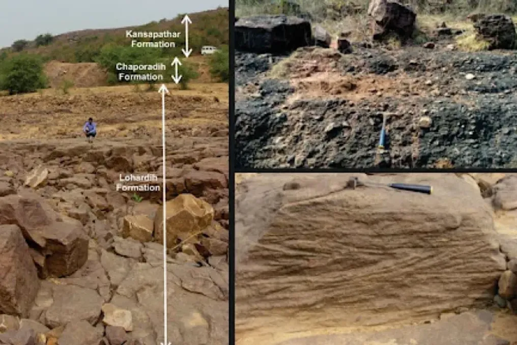
The history began with a process called rifting. Approximately 1.4 billion years ago, the Earth's crust beneath present-day central India began to pull apart. As the ground subsided, a deep valley formed, known as an intracratonic rift basin. This young, uneven landscape was dominated by alluvial cones, steep slopes of debris and gravel washed down from nearby highlands by ancient rivers. Researchers found evidence of these turbulent beginnings in the Lohardih Formation, the lowest layer of the basin, filled with poorly sorted, coarse-grained rocks, indicating rapid sedimentation by powerful floods in a semi-arid climate.
As millions of years passed, the Earth's crust stabilized, and the valley began to widen and sink deeper. This allowed the sea to advance from the northwest, transforming the rift valley into a passive margin basin, similar to modern Atlantic coastlines. Scientists identified a transition where early river deltas were submerged by the rising ocean. In the middle layers, known as the Chapardih Formation, the team discovered fine-grained muds and shales, suggesting a deeper, quieter marine environment where silt could settle in calm waters.
The final chapter of the Chandrapur Group's history is written in the Kansapatar sandstones at the top of this sequence. Here, the team found mature quartzites—very pure, well-sorted sandstones, indicative of a stable, long-lived coast. Patterns in these rocks, such as hummocky cross-stratification, reveal a picture of an ancient shore frequently subjected to powerful storms and shaped by strong tides. By this point, the basin had become an epicontinental sea—a shallow sea located on the continent's surface, rather than a deep oceanic basin. This transition from a chaotic rift to a stable sea is a perfect example of how the Earth's crust recovers and calms over vast geological timescales.
The formation of the Chhattisgarh Basin has been controversial among scientists; some argued it was a foreland basin formed under the pressure of mountains pushing on the crust. However, the new study provided a more complete map of the east-central region, directly linking sedimentary layers to tectonic impulses. Their work supports the 'rift-to-sea' model and correlates the birth and death of the basin with the global cycle of supercontinents, specifically the breakup of the supercontinent Columbia and the subsequent assembly of Rodinia.
Nevertheless, the researchers noted that studying such ancient rocks involves significant challenges. One major limitation is the lack of continuous outcrops in some areas. Over a billion years, most of the rock has been eroded or buried by younger deposits, making it difficult to trace every layer across the landscape. The scientists emphasized that to gain an even clearer picture of subsurface structures, future research will likely require the use of geophysical tools, such as seismic or gravity surveys, to see what is hidden beneath the surface where rocks are not visible to the naked eye.
Despite this, this study represents the first complete history of the origin and evolution of the Chhattisgarh Basin. By mapping the Earth's crust's response to ancient tectonic stresses, scientists can better predict the planet's future behavior, helping us understand the long-term stability of the continents we call home.