In many African cities, the landscape plays a defining role in daily life: rivers flow through residential areas, hills shape streets, wetlands collect rainwater, and mountains rise behind homes and offices. These natural features are not just places to visit on weekends; they influence urban development, people's modes of transport, and the uniqueness of each settlement.
From the Nile in Uganda to the highlands of Angola, seven African cities demonstrate how geography can become an integral part of the urban environment.
Jinja: Connection to Water
The city of Jinja in Uganda is inextricably linked to its aquatic environment. It is situated near Lake Victoria, and the Victorian Nile flows out of the lake on the eastern edge of the city. The municipal area also includes several islands.
This geography has helped Jinja become one of Uganda's most famous tourist destinations. The Nile is central to activities such as rafting, cruising, and bungee jumping, and the river and lake have also played a vital role in the city's industrial and economic development. Moreover, the appeal of Jinja's landscape is not limited to adrenaline activities; the presence of water is felt everywhere—on riverbanks, with views of the lake, and amidst the vast green landscapes around the Nile, giving the city a different rhythm compared to inland Ugandan cities.
The landscape is also part of Jinja's history, which developed as an important trade and transport hub, with the Nile supporting hydroelectric power and industry. Today, visitors come for the river, but it has always been part of the city's daily life.
Kisumu: City on the Lake Shore
On the northeastern shore of Lake Victoria, Kisumu is one of East Africa's great lakeside cities. The city positions itself as the main urban center of the Lake Victoria Basin and a major economic, cultural, and transport hub in western Kenya.
Lake Victoria transforms the experience of being in Kisumu. The waterfront is not an isolated attraction but a place connected to fishing, food, transport, recreation, and local livelihoods. At Dunga Beach, boats and fishing activities remind one that the lake is both picturesque and a working body of water. Otherwise, the lake serves as a backdrop for walks, restaurants, and everyday city life.
Kisumu's geography also provides it with a role as a transport hub. From here, travelers can explore other parts of the Lake Victoria basin, and local attractions include the Kisumu Museum and the Kisumu impala reserve. As a result, Kisumu feels like a water-oriented city; the lake is not a mere proximity but one of its defining components.
Kigali: City Among Hills
Kigali is often described because of its hills, and this is justified. The capital is located on a landscape consisting of steep slopes, valleys, rivers, and wetlands, rather than a flat plain. The city's natural setting is unusually integrated into its built environment. A strategic environmental assessment of Kigali showed that steep slopes, rivers, wetlands, forests, and agricultural lands together occupy a significant portion of the city's landscape.
The hills affect the movement of Kigali's residents: roads ascend and descend between ridges, and valleys create a sharp contrast with the dense development above. However, the wetlands are perhaps the most telling part of this story. They are not just green zones; Kigali's wetlands accumulate and release water, help mitigate floods, and provide ecological benefits within the city. The city undertakes major wetland restoration projects, linking environmental protection with flood management, recreation, and quality of life. Some of these restored areas become places where residents can walk, spend time outdoors, and enjoy nature without leaving the capital. In Kigali, the landscape is not just an object of contemplation; it helps the city function.
Addis Ababa: City of Altitude
Addis Ababa is a city shaped by altitude. Located in the Ethiopian highlands, the capital sits beneath the Entoto mountains, whose forested slopes rise above the northern boundary of the city. Entoto is more than just a backdrop; its forests, trails, and viewpoints have become part of city life through Entoto Park, where residents can walk, cycle, and spend time outdoors without leaving the capital.
Water also becomes more noticeable in the urban landscape. In June 2026, the city opened the Entoto–Kechene river development, restoring a river corridor with green spaces and public amenities. Collectively, the mountains, forests, and waterways give Addis Ababa its highland character. Here, nature is not just outside the city limits—it is woven into the very fabric of the capital.
Mbabane: Mountain Silhouette
Mbabane impresses not because of skyscrapers, but because of the surrounding mountains. The capital of Eswatini is located on the Mbabane River and its tributary Polinjane within the Mdzimba Mountains. This location gives Mbabane a distinctly mountainous character. The city is greener and topographically more diverse than many South African capitals, with roads and neighborhoods following the contours of the surrounding terrain. The mountains also influence the city's climate and its appeal as a nature retreat. Instead of feeling like an urban center with nature on the outskirts, Mbabane seems organically integrated into its landscape. This is particularly noticeable when moving through the city: roads climb and descend, views unexpectedly open up between buildings, and the surrounding mountains remain a constant presence. Thus, for travelers exploring Eswatini, Mbabane can be more than just a stopover; it can be an opportunity to see a capital whose physical appearance is part of its character.
Lobango: Angolan Plateau
Lobango is one of the most impressively situated inland cities in Africa. The capital of the Huila province in Angola, located at an altitude of approximately 1700 meters above sea level, rests on a high plateau surrounded by mountains and dramatic cliffs. The city's high elevation provides a cooler climate and a landscape significantly different from Angola's more well-known coastal cities.
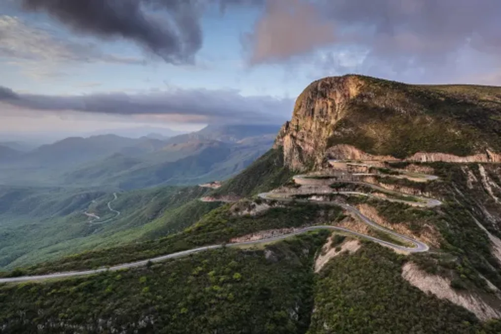
Further on is Tundavala. About 18 kilometers from Lobango, the Rift Tundavala marks the edge of the Huila Plateau, where the land drops sharply into the lowlands. The local tourism authority describes this as a major geological and scenic attraction, also emphasizing the cultural significance of the landscape for local communities. The Serra da Leba pass presents another outstanding example of relief with its winding road descending through the mountains. However, the landscape is not merely an object of contemplation from Lobango. The highland environment influences the city's climate, vegetation, agriculture, and architecture. Parts of the city are framed by jacarandas and eucalyptus, while the surrounding plateau supports farming and livestock. Lobango demonstrates how radically geography can change a city's character: in the Angolan highlands, the mountains are not a backdrop but the setting itself.
These cities are very different, but they share a common trait: their landscapes cannot be separated from city life. In Jinja, the Nile and Lake Victoria influence recreation, industry, and identity. In Kisumu, the lake shapes the city's relationship with food, fishing, and trade. Kigali's hills and wetlands determine the flow of water through the city, while the mountains and Atlantic coast of Maputo define its physical boundaries. Mbabane's mountain landscape gives Eswatini's capital its distinct mountainous character. Lobango's plateau and cliffs shape the climate and scenery around the southern Angolan city, while Harare's wetlands provide an inconspicuous but necessary natural infrastructure. They serve as a reminder that some of Africa's most interesting cities are not places where one has to choose between city and nature.