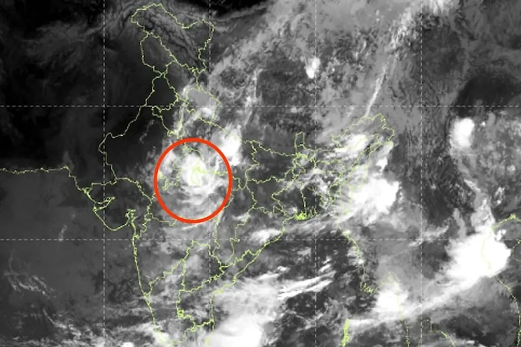
Thermal infrared photography obtained by the INSAT-3DS satellite from the Indian Meteorological Department (IMD) captured a massive cluster of monsoon clouds over a significant part of the country. This image demonstrates a dense layer of bright, thick clouds over central India, the Ganges plains, and eastern states.
These clouds are associated with intense convection processes, which could potentially lead to heavy downpours and thunderstorms. From a scientific perspective, this indicates that the monsoon remains active, but its intensity and distribution differ from previous patterns.
The satellite image shows a wide band of clouds stretching from central India to states such as Bihar, Jharkhand, West Bengal, and the northeastern states. Cloud activity is also clearly observed in Madhya Pradesh and surrounding areas. According to meteorologists, this pattern is forming due to the interaction of low-pressure zones and monsoon flows.
It is expected that during the first two weeks of September, there may be numerous periods of moderate and heavy rainfall in eastern India. Localized heavy precipitation may occur in areas of low-pressure system activity, increasing the risk of flooding or inundation in areas with already moist soil.
The monsoon is no longer manifesting uniformly across the entire country. Rainfall is predicted to persist in the east, while large areas of northwestern, western, and southern India may remain relatively dry. This unevenness could be a consequence of climate change and shifts in seasonal wind directions.
While river water levels may rise in the east, farmers in the west and south may face drought issues. Meteorological models suggest this trend will continue in the coming days, having varied impacts on agriculture, water resource management, and urban life at the regional level.
Episodic rains are also forecast in the National Capital Region. Clouds forming during the day and localized convective activity may bring showers and thunderstorms in the evening or after noon. These precipitations are highly localized: one area might experience heavy rain, while a neighboring one might only have cloud cover. Residents of Delhi-NCR are advised to monitor weather updates and avoid flood-prone areas.
This space-based image is living evidence of the changing monsoon in India. The continued cloud accumulation in the eastern half promises further rains there, while other regions may remain relatively calm. Farmers, city dwellers, and disaster management teams should pay attention to regional forecasts. This monsoon unevenness reminds us that the climate has become more uncertain, and timely preparation is crucial.