Most of Brazil to face intense heat up to 40°C, with storms expected in Rio Grande do Sul
Read more
Olhar Digital
olhardigital.com.br

Most of Brazil to face intense heat up to 40°C, with storms expected in Rio Grande do Sul

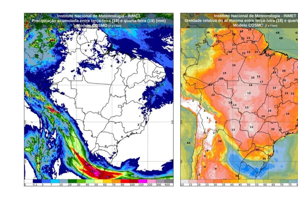
A significant part of Brazil is expected to face intense heat and very dry air, with maximum temperatures potentially approaching 40°C between Tuesday (the 18th) and Wednesday (the 19th). Simultaneously, storms are forecast for Rio Grande do Sul.

The low humidity warning applies to almost all regions, with the lowest readings recorded in the Central-West region and southern Amazonia. However, instability and heavy rains are concentrated in the western part of the North region and along the Northeast coastal strip.

Regional Weather Forecast

Weather in Rio Grande do Sul is expected to be highly unstable. The state is forecast to experience heavy rains, thunderstorms, and a risk of storms, with possible precipitation accumulation exceeding 100 mm in southern Gaucho. In Porto Alegre (RS), daytime temperatures will rise from 18°C on Tuesday to 25°C on Wednesday. In Paraná and most of Santa Catarina, the weather will remain more open and warm. Northern Paraná draws attention due to low air humidity levels.

This region is predicted to have prevailing sunshine, high temperatures, and dry air inland. INMET has issued a low humidity danger warning for northwestern São Paulo and western Minas Gerais. Coastal areas of São Paulo and Rio de Janeiro should see more cloud cover, with a possibility of light rain in southern São Paulo. Nights inland in Minas Gerais remain cold, with lows reaching 9°C. Maximums of 31°C are forecast for Belo Horizonte (MG) and Rio de Janeiro (RJ).

Heat and extreme drought should dominate all states in the region and the Federal District. Relative humidity is dropping to critical levels, fluctuating between 12% and 15%. Clear skies and scattered clouds are expected in most cities. Only northwestern Mato Grosso may register fast and isolated rain. Temperatures are expected to rise rapidly, with a maximum potentially reaching 39°C in Cuiabá (MT), 38°C in Campo Grande (MS), and 30°C in Brasília (DF).

Heat and sunny weather are forecast for the interior Northeast, while a low humidity warning has been issued for southern Maranhão, Piauí, and western Bahia. In Teresina (PI), thermometers may show values ranging from 20°C to 37°C. Rain is expected to concentrate along the coastal strip, from the eastern coast of Bahia to Pernambuco and Rio Grande do Norte, with isolated downpours. In coastal capitals such as Fortaleza (CE), temperatures should be more moderate, ranging from 22°C to 31°C.

Dry weather and intense heat will dominate Tocantins, Rondônia, southern Paraná, and southeastern Amazonia—regions under a low humidity warning. A maximum of 38°C is forecast for Porto Velho (RO), while Palmas (TO) will show a minimum of 21°C. Rain is expected to be more concentrated in the west of the region. Acre, Amazonas, Roraima, as well as the coastal strip of Paraná and Amapá, have forecasts of isolated showers with thunderstorms.

Similar stories

INMET forecast indicates heat increase in the country and risk of storms in the South Region this Thursday and Friday
Read more
olhardigital.com.br

INMET forecast indicates heat increase in the country and risk of storms in the South Region this Thursday and Friday

The National Institute of Meteorology (INMET) projects distinct weather conditions for Brazil over the next two days, Thursday (13th) and Friday (14th). While the North, Northeast, Central-West, and Southeast regions will experience predominant heat with low humidity, the South Region will face strong instability.

The most concerning situation is observed in the South, where the interaction of a trough linked to a low-pressure area favors the formation of storms. There is potential for intense rainfall, hail, wind gusts, and sporadic occurrences of tornadoes, although the exact locations of these events cannot be determined in advance.

Additionally, INMET monitors the possibility of a heatwave in parts of Amazonas, Pará, Central-West, Southeast, and Paraná. However, this condition has not yet been confirmed, depending on maximum temperatures remaining at least 5°C above average for five consecutive days.

On Thursday, heat will dominate much of the country's interior, accompanied by low humidity in various areas. In the Northeast, the interior will have drier weather, while the coastal area will concentrate conditions favorable for rain. States such as Maranhão, Piauí, Ceará, Rio Grande do Norte, Paraíba, Pernambuco, and Bahia have areas under the influence of drier air, with yellow alerts for low humidity in specific sectors, such as the south-central part of Maranhão and large parts of Piauí.

Temperatures remain high in the Northeast: Teresina may reach 37°C (minimum of 20°C), Fortaleza forecasts a variation between 24°C and 31°C, and Recife is expected to register between 22°C and 28°C. Areas on the northern coast of Bahia and southern Sergipe, as well as northern Maranhão, may receive isolated rains.

In the North, cloudiness and rain are more evident in Acre, Amazonas, Roraima, Amapá, and parts of Pará. Precipitation tends to focus on western Acre, west-central and northwestern Amazonas, and Roraima. Tocantins and south-central Pará will maintain few clouds. Palmas and Porto Velho may reach 37°C, and Manaus may reach 36°C. There is a yellow alert for low humidity in Rondônia, southeast Amazonas, south-central Pará, and Tocantins.

The Central-West will have few clouds, with a chance of isolated rain in northwest Mato Grosso (including Colniza, Aripuanã, and Cotriguaçu) and in southern Mato Grosso do Sul (Mundo Novo region). The heat will be intense, with highs close to 40°C in the interior. Brasília may record a minimum of 18°C, and Goiânia may reach 37°C. The entire region is under a yellow alert for low humidity.

In the Southeast, Thursday will begin with a possibility of fog on the northern coast of São Paulo, Rio de Janeiro, and Espírito Santo. Later, the weather will stabilize across most of the region, although southern São Paulo, near the border with Paraná, may present isolated rain and thunderstorms. Belo Horizonte will have a minimum of 14°C and a maximum of 32°C. The yellow alert for low humidity covers north-central São Paulo and large parts of Minas Gerais, except for the eastern strip of Minas Gerais.

The greatest concentration of instability occurs in the South Region. Rain and thunderstorms will affect areas of Rio Grande do Sul, Santa Catarina, and Paraná, with conditions worsening during the afternoon. Santa Catarina has an orange alert in the south-central, west, and east, covering cities such as São Miguel do Oeste, Chapecó, Campos Novos, Caçador, Lages, Brusque, Florianópolis, São Joaquim, and Criciúma. In Rio Grande do Sul, the alert reaches locations such as Santo Ângelo, Passo Fundo, Erechim, Caxias do Sul, Santa Cruz do Sul, and Porto Alegre.

There is also a yellow alert for storms in Paraná, encompassing Cascavel, Foz do Iguaçu, Guarapuava, Ponta Grossa, and Curitiba, as well as northeastern Santa Catarina (with Blumenau and Joinville) and central areas of Rio Grande do Sul (such as Santa Maria, Camaquã, and Mostardas).

Despite the instability, the South maintains milder temperatures, especially during the early morning. Curitiba and Porto Alegre may record lows of 13°C. The Paraná capital may reach 22°C, while Porto Alegre is expected to be among the coldest capitals, with a maximum of up to 18°C.

On Friday, instabilities shift towards Paraná and persist over Santa Catarina and northern Rio Grande do Sul. A vast area of Paraná, the entire territory of Santa Catarina, and north-central Rio Grande do Sul may experience rain and thunderstorms. The environment remains conducive to hail and wind gusts, without ruling out isolated tornado occurrences.

The yellow alert for storms remains largely in Paraná, including Cascavel, Foz do Iguaçu, Guarapuava, Ponta Grossa, Campo Mourão, and Curitiba. Santa Catarina and northern Rio Grande do Sul are also under alert, mentioning Ijuí, Erechim, Passo Fundo, Lajeado, Caxias do Sul, and Porto Alegre.

In southern Rio Grande do Sul and northern Paraná, instability decreases, but the possibility of rain persists. Nighttime temperatures remain low in Rio Grande do Sul and Paraná; Curitiba may reach 22°C, and Porto Alegre is expected to have a maximum of up to 18°C. Conversely, highs in northern Paraná show a tendency to rise.

In the North, rain intensifies in western Amazonas, with isolated showers and thunderstorms predicted. Acre, central Amazonas, and the coastal strip between Amapá and Pará may also rain, while Roraima may have isolated precipitation. Tocantins, south-central Pará, and southeast Amazonas will maintain few clouds and high heat, with a trend of temperature increase in central-east Amazonas and western Pará.

In the Northeast, rain is mainly restricted to the coastal strip, with forecasts of showers on the northern coast of Bahia (including Salvador), the coast of Sergipe, and areas of the coast and northwest of Maranhão. Isolated rain is also possible on the east coast of Rio Grande do Norte and northern Paraíba. The interior remains dry and hot in certain areas of Maranhão, Piauí, Pernambuco, and Bahia.

The Central-West should have few clouds over most of the territory, except for southern Mato Grosso do Sul, which may have isolated rain. The general scenario is one of high temperatures, with expectations of increasing heat in the coming days.

In the Southeast, the weather remains stable across most of the region. Espírito Santo, Rio de Janeiro, and central-east São Paulo will have greater cloud cover, while western and northern São Paulo and areas of central-west and northern Minas Gerais (including the Triângulo Mineiro) will have little cloudiness. In southern São Paulo, near Paraná, the chances of isolated rain and thunderstorms return, with a yellow alert for potential storm danger in Iguape, Registro, and Cananéia. The interior of the Southeast continues with a trend of high temperatures, especially in western and northern São Paulo and in Minas Gerais.

The regional contrast defines the forecast: while the interior of the North, Northeast, Central-West, and Southeast faces heat and low humidity in various points, the South concentrates the conditions most favorable for storms, maintaining an unstable environment due to low pressure, troughs, and moisture transport.

After cyclone, temperature drops in the South Region; Porto Alegre may record 8°C
Read more
olhardigital.com.br

After cyclone, temperature drops in the South Region; Porto Alegre may record 8°C

An intensifying extratropical cyclone over the South Atlantic has placed the Southern Region on alert between Thursday (6) and Friday (7). This phenomenon increases the risk of strong winds, storms, and hail.

The effects of this cyclone are also expected in southern Mato Grosso do Sul and São Paulo, where the National Institute of Meteorology (Inmet) forecasts isolated rains and thunderstorms. The most severe scenario is in the south-central part of Rio Grande do Sul, which is under a red alert for great danger of storms. In all three states of the Southern Region, the forecast points to intense rain, thunder, wind gusts, and the possibility of hail.

On Friday (7), although the cyclone begins to move away, it will still maintain areas of instability over Paraná and western Santa Catarina. Subsequently, a cold air mass will advance, causing a sharp drop in temperatures.

Main predicted impacts

Among the most significant anticipated impacts are the progression of unstable areas to southern Mato Grosso do Sul and São Paulo, maintaining conditions favorable for isolated rain and storms during the two forecast days. In São Paulo, precipitation is expected to increase in intensity, potentially reaching southern Minas Gerais and Rio de Janeiro. This area will also remain under alerts related to strong winds and low humidity in specific locations.

In the Central-West, Mato Grosso do Sul is the main focus of windstorm and storm alerts, while other regions of the state will have stable weather. While the cyclone concentrates its effects in the South-Central region, rains will remain restricted to Western Amazonia and parts of the coastal strip of the Northeast.

In the interior of the country, the predominant weather is dry, characterized by low relative humidity levels in parts of the Central-West, Southeast, and Matopiba. In the Northeast, warnings of strong winds persist in certain coastal areas and low humidity in several states.

After the passage of the cyclone, a cold air mass will begin to advance over the Southern Region. Because of this, Porto Alegre may record 8°C on Friday night, while Palmas and Teresina have the potential to reach up to 36°C. Inmet continues to monitor the cyclone due to potential impacts on Southern Brazil.

Intense extratropical cyclone monitored near Southern Brazil may cause storms and temperature drop
Read more
olhardigital.com.br

Intense extratropical cyclone monitored near Southern Brazil may cause storms and temperature drop

The National Institute of Meteorology (INMET) is monitoring the formation of a strong extratropical cyclone located between Argentina, Uruguay, Southern Brazil, and the Atlantic Ocean. This system has the potential to generate storms, wind gusts, hail, and decreasing temperatures in the coming days.

The classification of this event as a 'bomb cyclone' still awaits the evolution of atmospheric pressure. Forecasts indicate that the period requiring the most attention should be between Thursday, the 6th, and Saturday, the 8th, with a special focus on the Southern Region.

It is important to clarify that the name 'bomb cyclone' does not refer to an explosion; it describes an extratropical cyclone that rapidly gains strength due to a sharp drop in pressure at its center. This process is known as explosive cyclogenesis and generally occurs when air masses with distinct characteristics meet.

The encounter between warm, humid air and cold air facilitates the creation of a low-pressure zone that can intensify rapidly. According to INMET, the system will begin to structure itself from a low-pressure area located between northern Argentina and Paraguay, subsequently progressing towards Uruguay and the coast of Rio Grande do Sul.

The projection indicates that the cyclone may reach its most vigorous phase on Saturday, the 8th, with an estimated central pressure of 940 hPa, before gradually moving into the South Atlantic. Even if the core of the system is over the ocean, the effects can reach the continent due to the associated cold front and instability zones.

Among the predicted impacts, the strongest winds are expected to occur over the Atlantic Ocean, potentially exceeding 100 km/h near the cyclone's center. On the coast and in parts of Southern Brazil, notably in Rio Grande do Sul and Santa Catarina, gusts exceeding 60 km/h are expected.

Although extratropical cyclones are frequent in areas where warm and cold air masses converge, only some demonstrate sufficient acceleration to be classified as bomb cyclones. The crucial factor to observe is the speed at which the system evolves, as abrupt changes in pressure reduce the preparation time for facing strong winds, storms, and climate changes.

After the cyclone passes, a high-pressure area is expected to promote the arrival of a cold air mass over Central-South Brazil, resulting in a drop in temperatures in the following days. INMET continues to issue meteorological alerts for the Central-South areas and advises the population to follow forecast updates, as the trajectory and intensity of the system may be adjusted based on new data.

Popular