Walking along a river gives a hike a more measured pace, as visitors stop to observe the water, cross banks, navigate stones, or pause by an attractive water body. South Africa is rich in impressive rivers, and exploring them doesn't always require a canoe or raft; many of the most enjoyable aquatic adventures are done on foot, following the rivers through mountain valleys, gorges, forests, and increasingly rugged landscapes.
Routes range from a trail near Cape Town to a multi-day trek in the Northern Cape. Here are some places where the best way to experience the river is simply to follow it.
If you enjoy hikes with water underfoot, Kromrivier is a good starting point. This trail is located in the Limietberg mountains near the Du Toitskloof pass. It follows the Krom River through fynbos scrub, rocky terrain, and river sections before reaching waterfalls and clear stone pools. The focus here is not on summiting a peak, but on following the water upstream, with elements of jumping over boulders and crossing rivers that add an adventurous character.
The trail is relatively close to Cape Town, but once you are among the rocks and flowing water, the city seems distant. GETAWAY previously highlighted the Kromrivier trail as one of South Africa's lesser-known aquatic havens, emphasizing the combination of rocky ravines, pools, and waterfalls.
It is important to remember that river conditions can change rapidly after rain. Permits from CapeNature are required, and tourists should check conditions before setting out, rather than assuming a familiar route will have the same water level every time.
Best Use Case:
A day hike where the river is part of the adventure, not just a sight to be viewed from a viewpoint.
Near Durban, the landscape changes abruptly as the Molweni and Nkutu rivers cut deep into the Krantzkloof gorge. This creates a network of wooded ravines, cliffs, waterfalls, and pools, with trails descending from the gorge edges into cooler, greener areas. Instead of following one continuous river trail, the experience here is moving through the water-shaped landscape.
The wider Molweni area also features community-organized hiking routes, including the Nogxaza Falls and Granite Slide trails. A recent eThekwini biodiversity report notes that hiking is currently the primary ecotourism product in the Molweni area, and these trails were developed as part of the region's growing conservation offering.
Krantzkloof is particularly suitable for those who want a wilderness experience without venturing deep into the countryside. The rivers have carved out unexpectedly wild landscapes near one of KwaZulu-Natal's major urban centers.
Best Use Case:
A forest, gorge, and waterfall landscape without the need for a multi-day expedition.
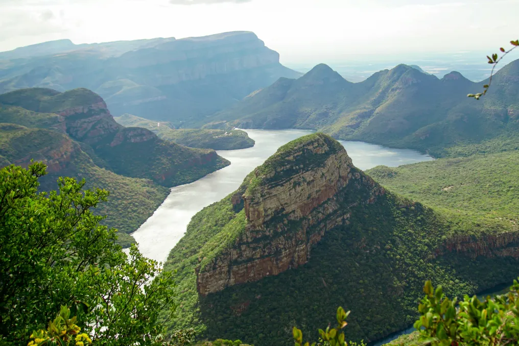
The Blyde River is responsible for one of South Africa's most recognizable landscapes, but the best way to grasp the scale of the canyon is to get off the road and walk through it. In the Blyde River Canyon Reserve, there are several hiking options, including the day hike Belvedere and the longer Waterval Trail. The latter is approximately a three-day route running from Paradise Camp towards Bourke’s Luck Potholes, traversing various sections of the canyon landscape.
This route is designed as a self-contained hiking adventure, with basic accommodation available along the way. It is not the type of river trip where you spend the whole day by the water; rather, the river serves as a connecting thread to the landscape. You walk through high mountain canyons, forested areas, and dramatic terrain while Blyde shapes the surrounding scenery.
For experienced hikers, the longer route transforms a place often visited by car sightseeing into a full-fledged trekking adventure.
Best Use Case:
A multi-day river landscape experience and for those seeking more than just a viewpoint.
The Orange River looks completely different when it reaches the arid Northern Cape. In the Augrabies Falls National Park, it has carved a massive canyon, culminating in the 56-meter-high Augrabies Falls. The park's most serious hiking option is the Klipspringer Hiking Trail, a three-day, 35.8 km route divided into three days. SANParks describes it as a challenging hike, with the second day being the hardest. The trail requires advance booking and is closed from October 15 to March 31 due to extreme heat.
For a shorter experience, there is the 8-kilometer Dassie interpretive trail, which follows the gorge and then returns to camp. The appeal of this location is not lush vegetation or cool mountain pools, but quite the opposite. The Orange River cuts through a vast, dry landscape of granite, rock, and desert vegetation, making the contrast between water and wildlife particularly stark.
And if you arrive when the river is running strongly, you will understand why the name given by the Khoi people, Aukoerebis, translates to 'Place of Great Noise.'
Best Use Case:
Dramatic landscapes, long treks, and observing how the river shapes the arid environment.
Oorlogskloof is a place that rewards travelers willing to slow down. The harsh landscape of the reserve is dissected by rivers and gorges, and waterfalls and pools serve as natural attractions along the walking routes. What makes Oorlogskloof interesting is the sense of scale. The water here is not just a place to swim at the end of a trail; it is part of a much larger landscape of cliffs, valleys, and open wilderness of the Northern Cape.
In warmer months, the pools along the river sections can provide a pleasant respite, but tourists should never take the river for granted. Rainfall upstream can quickly alter conditions, even if the weather above seems clear.
Best Use Case:
Wilderness with a sense of solitude, dramatic rock formations, and travelers who prefer less-trodden paths.
This route is slightly different. The walk along the Karkloof River was not designed as a traditional tourist trail. In 2017, a team from Karkloof Conservancy, WWF-SA, Endangered Wildlife Trust, and GroundTruth traversed about 65 km of the Karkloof River over six days, moving from source to confluence. Their goal was to assess the river's condition, including its biological health, water quality, and surrounding riparian environment. Thirty-seven sections were assessed along the route. It is an interesting reminder that a river trek can be more than just recreation.
The Karkloof River is part of the uMngeni catchment basin and flows into the uMngeni River and the Albert Falls dam, which is a vital water resource for Durban. You do not need to replicate the entire six-day research expedition to appreciate the idea. The river can be the destination itself, but it can also serve as a way to explore the landscape.
Best Use Case:
Curious tourists, nature-conscious travelers, and those who want to see rivers outside the usual focus of adventure tourism.
Hiking along rivers requires attention. A mountain route may have a summit as an obvious reward, whereas a river route is more unpredictable. The landscape changes depending on rainfall; water levels rise and fall, rocks become slippery, and a crossing that was easy last week might be unsafe next week. This is part of the appeal, but it also means that river hikes require more preparation. Check the weather and trail conditions before heading out, especially after heavy rain. Wear shoes with good grip and expect them to get wet on crossing sections. Carry enough water and food, even when the river is running alongside you, as untreated river water cannot be automatically considered safe to drink. And never underestimate moving water. If the river floods or a crossing looks unsafe, turn back. There is no photograph worth risking your life for.
To have a true river adventure, you don't need to float down the river. Sometimes the best experience is walking alongside it, crossing it, climbing above it, and finally sitting by a pool with tired legs and wet boots. South Africa's rivers flow through some of the most dramatic landscapes, from the sandy and forested gorges of KwaZulu-Natal to the granite wilderness of the Northern Cape. So next time you are looking for a water adventure, leave the canoe at home. Find a trail, follow the river upstream, and see where it takes you.