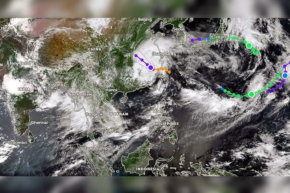
Seasonal disasters are currently prevalent in the Western Pacific Ocean, with several tropical cyclones active simultaneously. This situation is creating serious challenges for the countries in the region. Among these, Typhoon Dolphin has made landfall on China's eastern coast, while Tropical Storm Chan-hom is moving towards mainland Japan. Additionally, three other systems are circulating around the Mariana Islands.
This complex weather pattern is not only posing risks of heavy rainfall, strong winds, and flooding locally but is also feared to affect India's monsoon. Typhoon Dolphin proved to be the most powerful tropical cyclone to hit China this year. It made landfall near Yuhuan in Zhejiang Province at approximately 5:30 PM on August 9, 2026.
At the time of landfall, its maximum sustained wind speed was recorded at about 150-151 kilometers per hour, equivalent to a Category 1 storm on the Saffir-Simpson scale. The storm made another landfall near Wenzhou about an hour later. Before that, it passed through southern Okinawa Prefecture of Japan, resulting in power outages and some injuries.
The Chinese government had made extensive preparations in view of this storm, which included evacuating more than one million people to safe locations. Over nine lakh residents were displaced in Wenzhou city alone, and thousands of emergency shelters were established. Thousands of people were also evacuated in Shanghai, and approximately 1400 to 1500 flights were cancelled. Authorities issued a highest level red alert due to the threat of heavy rainfall, strong winds, flooding, and landslides.
The storm weakened and transformed into a tropical storm, now moving towards inland areas, where heavy rainfall is expected until Wednesday. Rainfall of 200 to 500 millimeters may occur in Zhejiang, Jiangsu, Anhui, and surrounding areas, increasing the risk of river flooding and landslides in hilly regions. The distinct feature of Dolphin was that it formed near an international border and traveled a long distance to reach China. Its lifespan was many times longer than a normal storm, and it achieved super-storm intensity. This event is also significant in the context of climate change, as warm sea surface temperatures promote such powerful and long-lasting storms.
Meanwhile, Cyclone Chan-hom is advancing towards Japan. It is the 14th system in the northwestern Pacific and is heading towards the northeastern parts of Japan, especially the central or northeastern parts of Honshu Island. It may make landfall or pass near the Japanese mainland by Tuesday evening or night. Currently, its wind speed is about 40-50 knots, and it may strengthen gradually, although it might weaken upon landfall.
Japan faces the threat of heavy rainfall, strong winds, and high sea waves from this storm. Combined with other active systems, it is making the region's weather even more unstable, leading to vigilance in many areas, including US military bases. After passing Chan-hom, it is likely to transform into a tropical depression while moving towards the Sea of Japan. Even in a developed nation like Japan, the level of preparedness is high, yet flooding, landslides, and traffic management can be challenging.
Several tropical systems are also active or have recently been active around the Mariana Islands (including Guam and the Northern Mariana Islands). These include Tropical Storm Palou and other disturbances circulating in the region. The simultaneous activity of multiple systems in the Western Pacific indicates unusually busy weather. Powerful storms like Super Typhoon Bawi have also passed through the Mariana area earlier this year, affecting Guam and surrounding islands.
These systems are generated due to warm seawater and favorable atmospheric conditions. El Niño can increase the number and intensity of storms in this region. Since these islands are small, they are easily affected by storms, which can disrupt basic services like electricity, water, and communication. Overall, the simultaneous activity of Dolphin, Chan-hom, Palou, and other systems in the Western Pacific is a subject of intense monitoring for meteorologists.
The question arises as to what impact these storms occurring in the distant Western Pacific might have on India's monsoon. Although these storms are not moving directly towards India, they can have an indirect effect through atmospheric circulation. Scientific research suggests that cyclonic storms active in the western North Pacific can influence the development of low-pressure areas in the Bay of Bengal.