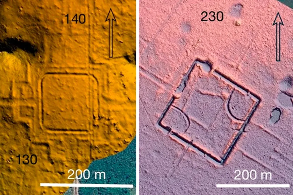
Researchers have identified hundreds of millennia-old geoglyphs hidden in the Amazon Forest. Initially, in the 1980s, geographer Alceu Ranzi noticed large geometric grooves while flying over the area between Rio Branco, in Acre, and Porto Velho, in Rondônia, using a window of a commercial airplane.
Intrigued by the finding, Ranzi returned to the region with a team of photographers and other researchers. This initial investigation led to the revelation of the first geoglyphs in the area: immense symbols carved and drawn directly onto the ground, created by ancient societies that lived in the Amazon.
Currently, technological advancements have facilitated the effort to decipher these structures in the interior of the tropical forest. A recent study, conducted by Brazilian researchers and published in the journal Nature, located 396 geoglyphs hidden in the forests of southern Amazonia, which were invisible due to dense vegetation.
The discovery was made possible by the use of LiDAR (Light Detection and Ranging) technology, which works by sending millions of laser beams from drones or aircraft toward the ground. When hitting an object or structure, the laser is reflected back to the device, allowing for the creation of a three-dimensional map of the underlying terrain.
Thanks to LiDAR, geoglyphs on the ground that were not visible in satellite images have been exposed. The investigation covered approximately 4,5 thousand square kilometers in the states of Acre, southern Amazonas, and also parts of Bolivia and Peru.
Most of the findings are associated with other important structures, such as circulation routes and probable ceremonial sites. On average, each geoglyph occupies almost three hectares, with some being nine meters wide and having a depth of nearly five meters. The largest recorded site discovered spans over 48 hectares.
Researchers link the construction of these works to the Aquiry civilization, an indigenous community that inhabited the southwestern Amazon between 6 BC and 9 AD. Evandro Ferreira, a professor at the Federal University of Acre (UFAC), commented in an interview with Super that he considers this people to possess highly developed knowledge.
Ferreira exemplified that 'they knew how to manage the forest' and that the elaboration of the geoglyphs required a large number of people, given that it was a complex task. He added that excavations indicate they cultivated manioc, in addition to having access to beans and peanuts.
With this new discovery, the total number of known geoglyphs in the region reaches 1,700. However, Ferreira suspects that the actual number could be considerably higher. He calculated that by extrapolating the 396 geoglyphs found across the entire area occupied by the Aquiry (about 185 thousand square kilometers), there could be up to 30 thousand geoglyphs.
It is relevant to note a historical aspect: the first geometric forms were only detected in the 1980s due to the deforestation process. At that time, the growth of livestock farming and the construction of highways, such as BR-317, removed extensive areas of the forest, allowing for the observation of the terrain through aerial means.
Although LiDAR has allowed analysis of areas with dense forest, revealing hidden symbols, the technique has limitations. According to Professor Ferreira, 'as you move towards Central Amazonia, the forest is denser and the effectiveness of the laser decreases,' with precision potentially dropping from 10% to 50% in those regions.
Similar geoglyphs have been found in countries such as Peru, including the famous Nazca Lines. Peruvian drawings include representations of animals, human beings, plants, and imaginary figures, in addition to geometric patterns.
The Nazca civilization consisted of advanced farmers, capable of thriving in a difficult geographical environment, located approximately 1,700 kilometers from the Aquiry in the Amazon. The vast quantity of geoglyphs in the southwestern Amazon leads archaeologists to reevaluate theories about the development of pre-colonial civilizations. One of the main changes is the perception of the size of these societies; previously, it was believed that indigenous groups were small, but now many archaeologists estimate that the population peak of the Aquiry could have ranged between 1.25 million and 3 million inhabitants during the period between 100 AD and 300 AD, as it would require, on average, about 300 people to build and maintain each geoglyph.