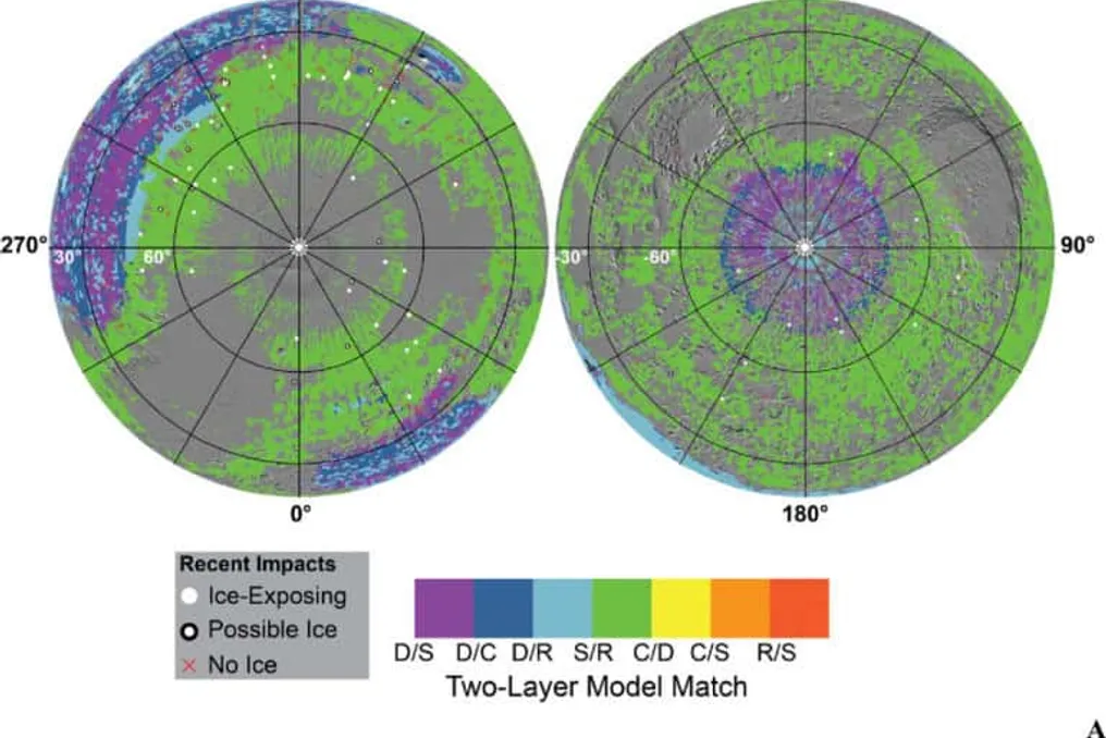
Two studies conducted by scientists from the Planetary Science Institute (PSI) have presented new global maps showing areas with the highest probability of subsurface water ice on Mars. These works, published in The Planetary Science Journal, also propose a new method for assessing the reliability of these estimates, which is crucial for planning future crewed missions to the planet.
The research is part of the Mars Subsurface Water Ice Mapping (SWIM) project and aims to identify regions that could provide resources for astronauts. In addition to pinpointing where ice is likely present, the scientists highlight zones requiring further data before they can be considered for human expansion.
Thermal maps help detect subsurface ice
Currently, water ice cannot persist for long on most of the Martian surface. Due to the planet's extremely thin atmosphere, the ice is susceptible to sublimation, transitioning directly from solid to gas.
Previous missions, such as the Phoenix probe, have already discovered buried ice in high-latitude regions, just a few centimeters below the surface. In areas closer to mid-latitudes—which are considered more suitable for future human operations—astronauts will likely need to dig deeper to find it.
According to Hannah Sizemore, one of the study leaders, ice extracted from the subsurface could be converted into hydrazine—fuel usable for return flights to Earth. This concept falls under the so-called In-Situ Resource Utilization (ISRU), a strategy that can reduce the mass and cost of a crewed mission.
To create the maps, the team used data from the Thermal Emission Spectrometer (TES) instrument of the Mars Global Surveyor mission and the Mars Climate Sounder (MCS) installed on the Mars Reconnaissance Orbiter, both belonging to NASA. These two instruments created thermal maps of the planet, allowing observation of how the surface and atmosphere react to changes in illumination between day and night, as well as throughout Martian seasons. Differences in heating and cooling rates help researchers infer what materials are located directly beneath the surface, at a depth of about one meter.
Model comparison increases reliability
Sizemore's new study compared the SWIM project maps with two other maps developed by different groups using various methodologies to process the same data. The researcher notes that estimating ice depth based on orbital thermal measurements is a complex process. Differences between instruments, numerical models, and even Martian atmospheric conditions, such as dust content, can distort the results.
Therefore, combining maps obtained using different datasets, hypotheses, and models enhances confidence in exactly where the ice is located—especially in transition zones between frozen and unfrozen areas. Overall, the maps showed good agreement. Areas of discrepancy were identified as candidates for future robotic missions that can gather new information before potential crewed expansion.
Statistics measure the probability of ice detection
The second article, led by Samuel Curvill, introduces a probability and statistics-based approach to assign formal confidence levels to subsurface ice maps. According to the researcher, while previous approaches only assessed the compatibility of orbital data with the presence of ice, the new method explicitly calculates the probability of its actual existence at each point.
Sizemore explains that this methodology allows for the transformation of a qualitative assessment into a quantitative one. Instead of simply stating that one technique detected ice and others did not, it becomes possible to assert, for example, that there is a 64% chance of finding ice at a specific point on Mars.
New technology may fill measurement gaps
The researchers emphasize that the currently used data only investigate the first meter of the Martian surface. On the other hand, existing radar technologies can only map ice at depths greater than five meters. This leaves an intermediate range, between 1 and 5 meters, without direct measurements. The authors believe that a high-frequency radar capable of detecting ice in this interval would significantly increase the reliability of the maps created by the SWIM project.
Both studies are included in a special issue of The Planetary Science Journal dedicated to the topic 'Crewed Expansion of Mars: Resources and Scientific Goals,' which compiles work aimed at identifying resources and scientific objectives for future human missions to the planet.