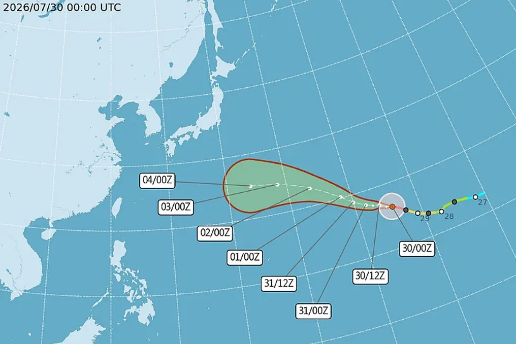
Several countries and territories in East Asia are preparing for the impact of a new powerful weather phenomenon that has become a super typhoon in the central Pacific Ocean.
Several countries and territories in East Asia are preparing for the impact of a new powerful weather phenomenon that has become a super typhoon in the central Pacific Ocean.
Super Typhoon Dolphin has become an extremely strong system near Wake Island and is moving southwest toward southern Japan, northern Taiwan, and mainland China. It is currently causing very rough seas and high waves, which are expected to affect maritime areas and island territories.
According to the U.S. Joint Typhoon Warning Center (JTWC), on Thursday, ST Dolphin generated waves up to 13 meters with sustained winds of 268 kilometers per hour and gusts up to 324 km/h. The center reported that these parameters are forecast to be even stronger over the next 48 hours.
ST Dolphin is the third super typhoon in the central and western Pacific Ocean this year. It is expected to be more powerful than Super Typhoon Sinlaku in April (with winds of 298 km/h) and Super Typhoon Bavi in July (with winds of 290 km/h).
ST Sinlaku caused 17 deaths in the Western Pacific region, including Guam, the Northern Mariana Islands, and the Federated States of Micronesia. ST Bavi caused at least 23-26 deaths in Asia (some remain missing), mainly due to severe flooding and landslides in the Philippines triggered by the strengthening of the southwest monsoon due to this storm.
The Pacific Ocean is currently in a super El Niño phase—an unusually powerful climate regime that occurs when the average sea surface temperature in the central and eastern equatorial Pacific Ocean rises by 2°C or more above normal. Super El Niño does not increase the total number of tropical storms, but it creates conditions conducive to the formation and significant intensification of individual typhoons into super typhoons.
According to Hellenic Shipping News, ST Dolphin is expected to disrupt shipping activities off the coast of mainland China, which has not yet recovered from ST Bavi. The publication added that 'the immediate risk lies in delayed unloading, increased congestion in deeper anchorages, and stricter provisioning of vessels in the Pacific Ocean.'
The Japan Meteorological Agency has warned of predicted extreme sea conditions, strong waves, and high swells near the country's Ogasawara Islands. Currents indicate that the threat will remain predominantly maritime, although monitoring will be conducted for potential indirect impacts on the Pacific coast.
The Vietnam National Center for Hydro-Meteorological Forecasting has warned that next week ST Dolphin may cause strong winds and high waves in the East Sea (South China Sea), excluding it. Meanwhile, Filipino meteorologist Benison Estareha stated that ST Dolphin is likely to cross Philippine waters but will not cause significant local weather impacts.
The Egyptian Meteorological Authority (EMA) has warned about upcoming weather conditions and sustained high temperatures. This coincides with the arrival of the Indian Monsoon minimum, nicknamed the 'Summer Monster,' which significantly increases humidity levels, intensifying the feeling of heat.
EMA has released the weather forecast for August 2026, predicting extremely hot daytime conditions in most regions, as well as hot and humid weather along the northern coast. Nighttime and early morning are expected to be moderately warm and humid.
Humidity levels will continue to rise, causing the perceived temperature to be 2–4 degrees Celsius higher than the actual readings in the shade. Meteorological maps warn of possible fog formation between 4:00 AM and 8:00 AM on certain roads connecting the northern parts of the country, passing through Greater Cairo, Canal Cities, Central Sinai, and Upper Egypt North; in some places, the fog may become dense.
Furthermore, from Friday to Tuesday, intermittent winds are expected in some areas of the Northwest Coast, Greater Cairo, Lower Egypt, and Upper Egypt South.
According to EMA's statement, maximum temperatures in Greater Cairo and Lower Egypt will range from 37°C to 39°C, with the perceived temperature peaking at 42°C on Sunday—the culmination of this extreme heatwave. Meanwhile, Upper Egypt South will record the highest overall temperatures during this period: actual maximums will vary from 43°C to 46°C, and the perceived temperature could reach 47°C.
According to the Hydrometeorological Service of the Republic of Uzbekistan, on August 1, variable cloudiness is expected in Tashkent with no precipitation. The wind from the east will blow at a speed of 3-8 meters per second. The night temperature will be 24-26 degrees, and during the day—38-40 degrees.
Variable cloudiness is forecasted for the Republic of Karakalpakstan and the Khorezm region, with no precipitation expected. The wind from the east will blow at a speed of 7-12 m/s. Night temperatures will be 22-27 degrees, and daytime temperatures—35-40 degrees.
Variable cloudiness without precipitation is also expected in the Bukhara and Navoi regions. The wind from the east will blow at a speed of 7-12 m/s, although in some places, the wind speed may increase to 13-18 m/s due to dust storms. Night temperatures will be 22-27 degrees, and in desert areas, daytime temperatures will be 38-43 degrees, and nighttime temperatures—30-33 degrees.
Variable cloudiness and no precipitation are expected in the Tashkent, Samarkand, Jizzakh, and Syrdarya regions. The wind from the east will blow at a speed of 7-12 m/s, and in some places, the wind speed may reach 13-18 m/s combined with dust. Nighttime temperatures will be 22-27 degrees, and daytime temperatures—36-41 degrees.
Variable cloudiness without precipitation is also forecasted in the Kashkadarya and Surkhandarya regions. The wind from the east will blow at a speed of 7-12 m/s, with the possibility of increasing to 13-18 m/s if there are dust storms. Night temperatures will be 22-27 degrees, and daytime temperatures—38-43 degrees.
Variable cloudiness without precipitation is expected in the Andijan, Namangan, and Fergana regions. The wind from the east will blow at a speed of 5-10 m/s. Night temperatures will be 22-27 degrees, and daytime temperatures—36-41 degrees.
Variable cloudiness with changes is expected in the republic's mountainous areas, but without precipitation. The wind from the east will blow at a speed of 7-12 m/s, and in some places, it may increase to 13-18 m/s. Night temperatures will be 15-20 degrees, and daytime temperatures—28-33 degrees.