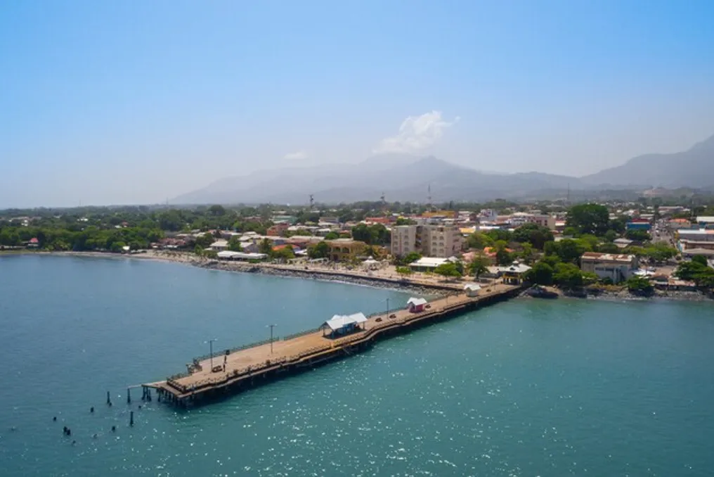
On the Caribbean coast of Honduras, specifically in the Leán Valley, a coastal strip bordered by the Nombre de Dios Mountain Range to the south and the Caribbean Sea to the north, the landscape was historically characterized by dense jungle, swamps, and little infrastructure. This picture began to change with the arrival of the Garifuna people, who settled in the region between the Danto and Cangrejal rivers, laying the foundation for the development of the city of La Ceiba.
Origins and Early Settlements
La Ceiba emerged as an urban center in the Honduran Caribbean, whose trajectory was shaped by multiple migratory waves, including Central American, Afro-Caribbean, European populations, and the influence of North American corporatism. The Garifuna people, of Afro-Caribbean origin, were exiled by British colonial authorities from the island of St. Vincent to Roatán, Honduras, at the end of the 18th century (in 1797). Subsequently, Spanish authorities negotiated with the Garifuna community for a peaceful move to the city of Trujillo, on the Honduran mainland.
Around 1810, a group of Garifuna chose to move west, towards the Leán Valley, an unexplored area, and settled near the mouth of the Cangrejal River, founding the small village known as La Barra. According to Canelas Díaz, this settlement quickly integrated into the maritime trade circuits of the Caribbean, using the coastal geography and local resources to create small-scale trade networks linking the interior to regional ports.
Internal Expansion and Dual Structure
News of fertile lands and opportunities spread throughout the interior of Honduras, provoking migration from the departments of Olancho and Yoro, which marked the second historical phase of the city. These inland migrants used coastal routes passing through Trujillo or crossed the mountains. In 1835, the Pech families, an indigenous group from Honduras, also arrived from the department of Olancho. Due to the difficulty of securing a stable place in La Barra, caused by competition between the Garifuna and the newly arrived inland people, they settled near a large ceiba tree, not far from the Garifuna village.
In 1840, urban growth continued until it reached the ceiba tree, resulting in a dual urban organization: the village of La Barra, with strong Garifuna influence, and a second nucleus formed around the tree, which eventually gave the city its name. At this stage, La Ceiba functioned more as a cluster of neighboring settlements, united by commerce and labor exchange, than as a cohesive city.
Impact of American Corporations
The urban structure underwent a drastic alteration with the arrival of large United States corporations. In the 1860s, the banana culture rapidly expanded along the northern coast of Honduras. Near La Ceiba, the watersheds of the Leán Valley facilitated the start of banana plantations inland. Navigable paths allowed harvests to be transported downriver to ships anchored on the coast for purchase.
This activity attracted more waves of migration from various parts of the globe, with reports pointing to Europe, the Middle East, and North America. It was the American companies that formalized the banana trade in the city. Seeking greater efficiency and more accessible labor, these companies recruited workers from various British Caribbean colonies, such as Belize, Jamaica, Trinidad and Tobago, and St. Vincent. This introduced a new migratory layer into La Ceiba, consolidating what is today known as 'Barrio Inglés', integrating a multicultural Caribbean diaspora into the urban fabric.
The Banana Era and Urban Planning
The most decisive change occurred at the turn of the 20th century. In 1899, the company Vaccaro Bros. arrived from New Orleans and quickly implemented plantations, docks, and maritime transport operations in La Ceiba. With government concessions during the administration of Honduran president Manuel Bonilla, the company also expanded railway infrastructure along the Caribbean coast. From this accumulation of capital and logistics, the Standard Fruit & Steamship Company was born. Together with the United Fruit Company in the neighboring city of Tela, these two corporations inaugurated a new period in Honduran history, often called the Banana Republic.
Before this intervention, La Ceiba possessed a relatively organic settlement, with diffuse distribution neighborhoods. However, the urban planning dictated by the North American corporations imposed a parallel system. A notable example is Mazapán, a company-administered enclave located west of the city, which concentrated residences, schools, warehouses, workshops, and its own railway terminal. The creation of Mazapán generated spatial separation in La Ceiba: corporate infrastructure on one side and local urban life on the other.
Standard Fruit's land ownership also directed urban expansion, leading the city to develop new squares and establish new circulation axes along the railway lines and main avenues, such as San Isidro Avenue and La República Avenue.
Architectural Influence and Challenges
Immigration also influenced local architecture. Building styles brought from the southern United States became predominant. Plantation-style houses, characterized by wooden structures, zinc roofs, high ventilation, and wide verandas, created a unique Caribbean coastal architectural identity. This typology contrasted sharply with the Spanish masonry-based urbanism found in inland cities like Tegucigalpa, resulting in a national architectural divergence with two Honduran urban identities developing under distinct external influences.
However, the wooden construction made the city extremely susceptible to fires. Major fire outbreaks, particularly in 1924, repeatedly destroyed extensive areas of the urban core, forcing constant cycles of reconstruction. Over time, there was a transition to concrete construction, including the municipal building from the 1930s, located near the central park.
Economic Development and Isolation
At its peak, La Ceiba established itself as a financial center, housing important banks with currency issuance power. However, the city's growth was not autonomous. Despite its economic importance, La Ceiba remained geographically disconnected from the national road network of Honduras for much of its history, as access depended on railways controlled by the banana companies. This isolation was only overcome in 1965 when the CA-13 highway connected the city to the rest of the country.
Contemporary La Ceiba
Currently, the urban configuration of La Ceiba continues to be determined by existing geography and infrastructure. The CA-13 corridor stimulates linear expansion along the coast, while the historic center maintains administrative and commercial concentration. Former port areas have been transformed into public spaces, and vestiges of the banana era remain present in urban parks and the city's spatial patterns.
Today, La Ceiba is a metropolis built upon successive layers of migrations: from forced displacement and indigenous adaptation, to the importation of labor and corporate capital flows. Each of these layers reconfigured space rather than merely occupying it, culminating in a city of stratified identity, a product of the constant movement of people, goods, and economic power throughout its history.