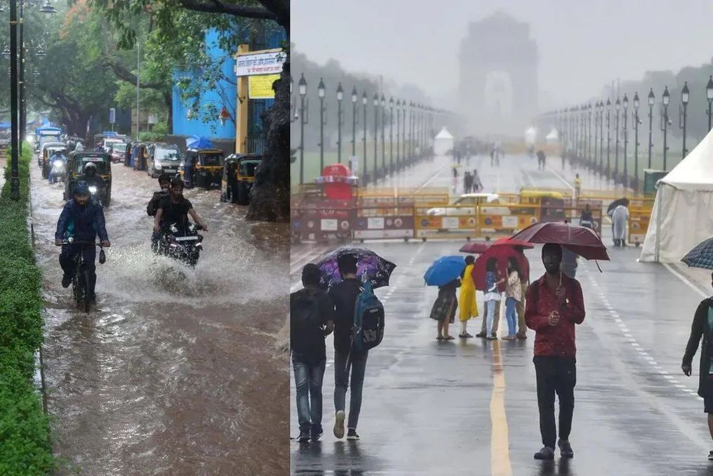
The southwest monsoon finally reached Delhi on Thursday, five days after the scheduled start date of June 27. This brought widespread precipitation and a long-awaited relief after several weeks of heat and high humidity.
Spread of the Monsoon Across the Country
The Indian Meteorological Department (IMD) reported that the monsoon has advanced into the capital and significant parts of northwestern India. Extremely heavy rains are expected in Maharashtra, Goa, Konkan, southern Gujarat, and some parts of central India in the coming days.
According to the meteorological service, on July 2, the monsoon continued its advance into the remaining parts of Uttar Pradesh, the entire territory of the National Capital Delhi, most of Madhya Pradesh, Haryana, and Punjab, as well as additional areas of Gujarat and parts of Rajasthan.
Timelines and Weather Forecasts in Delhi
Due to this advance, the monsoon is now close to covering the entire country, ahead of the usual end date by almost a week—July 8. The IMD considers the conditions favorable for the further spread of the monsoon into the remaining parts of Gujarat, Madhya Pradesh, Haryana, Punjab, and Rajasthan over the next two to three days.
The arrival of the monsoon marked a significant climatic transition for Delhi after a period of extreme heat, dust storms, and pre-monsoon thunderstorms. According to the IMD, this is the first instance since 2021 that the southwest monsoon reached Delhi in July. In 2021, the monsoon arrived on July 13.
The meteorological department forecasts mostly cloudy skies, moderate rainfall, thunderstorms, and gusty winds in Delhi-NCR during the day. A yellow alert remains in effect for the national capital. The rains have already caused a noticeable drop in temperature; on Wednesday, the maximum temperature recorded in Delhi was between 33°C and 34.8°C, significantly lower than the figures during the recent heatwave. The IMD expects maximum temperatures to remain within 32°C – 34°C over the next 24 hours.
Rapid Advance of Monsoon in North India
The monsoon's advance into Delhi occurs against the backdrop of the rapid movement of the southwest monsoon across northern India. On July 1, the monsoon covered the entire state of Himachal Pradesh, six days late relative to its usual start date of June 25. It also spread to the remaining parts of Uttarakhand, Jammu and Kashmir, as well as Ladakh, entering large parts of Haryana and Punjab.
IMD officials stated that the remaining parts of Punjab, Haryana, and Rajasthan are expected to come under the influence of the monsoon within the next two to three days. Senior IMD scientist, Dr. Naresh Yadav, noted that the weather system will continue to move north, causing heavy rainfall in several states.
He warned of the possibility of extremely heavy rains over the Konkan, Goa, and southern Gujarat region over the next four to five days. The IMD has issued a red alert for these regions. Very heavy rains are also expected in Odisha and some parts of central India.
Flood Risk in the West and South
Although the arrival of the monsoon ended the prolonged heat in most of northern India, it simultaneously increases the risk of flooding in several western and southern areas. Heavy rains have already been recorded in the Mumbai Metropolitan Region, Konkan, coastal Maharashtra, and Goa, where inundation was observed in low-lying areas.
An orange alert is in effect for Mumbai, while Ratnagiri is under a red alert due to the possibility of extremely heavy rainfall. IMD officials reported that local authorities, including the Municipal Corporation of Mumbai and the State Disaster Management Authority, have been notified of potential flooding in vulnerable zones.
Causes of Intense Rainfall in the West
Despite Delhi welcoming the arrival of the southwest monsoon, western and southern India is experiencing its most intense phase. The IMD warns of extremely heavy precipitation in parts of Maharashtra, Goa, Konkan, and southern Gujarat in the coming days.
According to the IMD, a combination of favorable monsoon winds from the Arabian Sea, multiple cyclonic circulations in the upper layers of the atmosphere, and an offshore ridge extending from southern Gujarat to Karnataka contributes to widespread precipitation along the west coast of India.
The meteorological service also reported the probable formation of a low-pressure area over the northwestern part of the Bay of Bengal around July 3. After forming, this system is expected to intensify rainfall activity in eastern and central India before moving inland.
Situation in Himachal and Uttarakhand States
The southwest monsoon completed its advance through Himachal Pradesh on July 1, six days late relative to the state's normal start date. The IMD forecasts abundant rainfall in the hilly state over the next week, with heavy or very heavy rains expected in isolated areas. The influence of a new western disturbance is also expected from July 2, which could potentially intensify rainfall activity in Himachal Pradesh.
The weather has already had a serious impact on the state. According to the Central Emergency Operations Centre, weather incidents from March 1 to June 30 claimed 128 lives and caused losses of nearly 30 crore rupees. Heavy rains blocked dozens of roads across Himachal Pradesh, with the Mandi district being the hardest hit.
Neighboring Uttarakhand has also entered an active phase of the monsoon. The IMD has issued orange warnings for heavy or very heavy rainfall in some parts of the state, prompting authorities to activate emergency response systems and enhance monitoring along the Char Dham Yatra routes. District administrations have increased surveillance of highways, pilgrimage routes, and landslide-prone areas as rainfall is expected to intensify in the coming days.
Impact of Monsoon on South and Northeast
The active monsoon continues to affect southern and northeastern India. In Karnataka, three family members, including two girls, died after a rain-induced landslide buried their home in Mangaluru following incessant overnight rainfall. In Arunachal Pradesh, authorities continue efforts to provide aid and rehabilitation after sudden floods and landslides that caused widespread destruction over the past week. Official data indicates four deaths, 21 injured, and two missing. The center assured the state of support for relief operations and long-term flood mitigation measures.
Factors Contributing to Monsoon Activity
Meteorologists assert that the current period of widespread precipitation is due to the operation of several weather systems simultaneously. Cyclonic circulation persists over Punjab in the upper atmosphere, while another is active over central Uttar Pradesh. A separate circulation over Saurashtra continues to enhance moisture transport from the Arabian Sea. Meanwhile, the offshore ridge extending from southern Gujarat to Karnataka helps sustain heavy rainfall along the west coast of India.
The expected formation of a low-pressure area over the northwestern part of the Bay of Bengal is likely to further increase rainfall in eastern, central, and northern India in the coming days. The combination of these systems should sustain monsoon activity across large parts of the country throughout the first week of July.